Skip to content
Insights
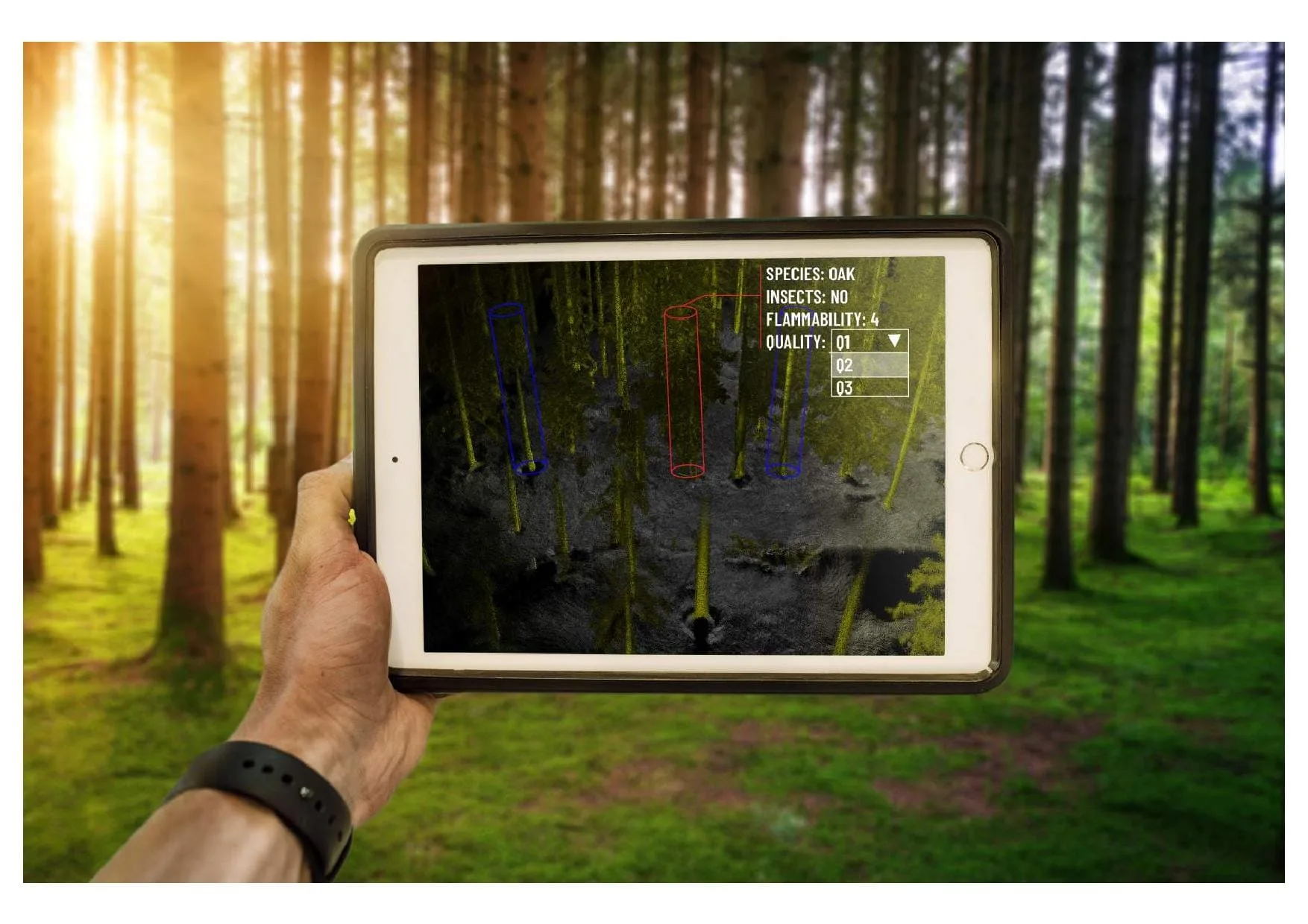
A person uses a tablet running Outsight’s real-time LiDAR solution in a forest, displaying tree data such as species, flammability, and quality for forestry management.

Outsight launches the first real-time LiDAR solution for the forestry industry

Outsight, a leader in 3D Spatial Intelligence, has announced the launch of the first real-time LiDAR solution for the forestry industry.


“With Outsight, we’re able to complete our surveys of the forest three times faster and, at the office, have a detailed inventory of the plot with all our notes automatically tagged to each tree.”, Philippe Nolet, Professor at Université du Québec (Canada)

PARIS, FRANCE–(EINNEWS)– Outsight is bringing the power of real-time LiDAR technology to the forestry industry, democratizing instantaneous forest mapping.

• An automated 3D solution that produces a 360° forest mapping in real time, and collects data on individual trees which operators can digitally tag
• Portable: the LiDAR box integrating Outsight’s software can be carried in a backpack and connected to a tablet for real-time surveys
• 3 to 5 times faster than usual data collecting methods while being accurate and exhaustive
• Offers GPS geolocation, allowing operators to overlap maps, if necessary

Outsight, a leader in 3D Spatial Intelligence, has announced the launch of the first real-time LiDAR solution for the forestry industry.

Drawing on its established LiDAR expertise in other industries, Outsight has developed a mapping solution capable of generating a comprehensive 3D map of a forest in real-time.

Taking no longer than the time needed for the human or machine operator to traverse the plot, Outsight’s solution automatically determines the exact position and characteristics of trees.

On-site operators can digitally tag each tree with supplemental information, including species or the presence of insects, that can be used for further analysis.

This solution further builds upon Outsight’s expertise in the environmental and forestry sectors.

In July 2020, Outsight was selected from a large pool of candidates to be a recipient of the European Innovation Council’s inaugural Green Deal funding. A part of the European Union’s Green Deal Strategy, Outsight was chosen for its LiDAR-based environmental and forestry management and conservation solutions.

Outsight’s solution is already being used by forestry researchers around the world. Esteemed forestry professor, Philippe Nolet, has been using Outsight’s LiDAR processing technology to assist in his forest monitoring research at Université du Québec en Outaouais in Gatineau, Canada.

“With Outsight, we’re able to complete our surveys of the forest three times faster”, says Philippe Nolet. “Then, when we’re back in the office, we have a detailed inventory of the plot with all our notes automatically tagged to each tree, saving us a huge amount of time.”

The solution has also been adopted by Outsight’s Hong Kong-based partner, Insight Robotics, a leader in the Forestry Risk Management sector. Using Outsight’s ground-based LiDAR tool to supplement its market-leading aerial survey solution, Insight Robotics can provide its clients with even more accurate survey data, allowing customers to better manage their forests and plantations.

“Outsight’s LiDAR solution allows our team to quickly and accurately map a section of the forest and use the 3D map to complement our aerial survey results”, says William Tao.

After the proven success of its forestry-focused LiDAR solution on three continents, Outsight is continuing to work on new features for this market.

Award-Winning Technology
Outsight has successfully designed and built the next generation of LiDAR processing solutions, which have been the subject of 73 patent applications.

Outsight’s innovative solutions have won numerous awards, including the prestigious Best of CES Innovation Award in Las Vegas and the Prism Award from world leaders in photonics and lasers.
Related Articles

TECHNOLOGY

Outsight Introduces the First LiDAR Pre-processing Software Engine

Outsight announced today the launch of a game-changing product: the Augmented LiDAR Box (ALB), the first real-time LiDAR Software Engine.

APPLICATIONS

OUTSIGHT raises €22 Million to accelerate the deployment of LiDAR across all industries

Outsight, a pioneer in 3D software based on LiDAR, obtained an investment of $22 million to accelerate its steady growth trajectory beyond autonomous vehicles.

Let's connect

Send us a Message

Drop your email and we'll get back to you as soon as possible.

Frequently Asked Questions

  • How fast can a backpack-mounted LiDAR system survey a forest plot compared to traditional methods?

    Backpack-mounted LiDAR systems can complete forest surveys three to five times faster than conventional field methods such as manual calliper measurement and written inventory forms. The speed gain comes from continuous point-cloud capture while the operator walks the plot: the system derives tree positions and dimensions automatically, rather than requiring the surveyor to stop at each tree. The practical limit is walking speed across the terrain, not instrument setup time. Outsight, which launched the first real-time LiDAR solution for the forestry industry, applies the same LiDAR-native, real-time perception pipeline that underpins its SHIFT platform to translate raw point clouds into structured forest inventory data without manual post-processing delays.

  • What tree-level data can a ground-based LiDAR forest survey actually collect?

    A ground-based LiDAR survey derives each tree's exact position, stem geometry, and canopy envelope from the 3D point cloud. Outsight's real-time LiDAR solution for forestry extends this capability by enabling operators to attach supplemental attributes, such as species, health status, or pest presence, as digital tags to individual tree records directly in the field. The result is a geo-referenced inventory where spatial coordinates and manually entered metadata are linked per tree, making the dataset directly usable for stand-level modelling or forest management plans without a separate digitization step. This approach applies the same infrastructure-based 3D perception principles that Outsight has deployed across airports, train stations, and smart-city environments to the specific data-collection demands of forest inventory.

  • How does a real-time LiDAR forest map integrate with aerial survey data?

    Ground-based LiDAR captures the understory and lower stem geometry that aerial surveys miss due to canopy occlusion. When GPS geolocation is embedded in the ground scan, the two datasets share a common coordinate reference and can be layered: the aerial pass supplies canopy-top structure and large-area coverage, while the ground pass fills in stem-level detail. Outsight's real-time LiDAR solution for forestry applies this infrastructure-based sensing approach, processing 3D point clouds at sub-50ms latency so that ground-level scans can be aligned and fused with aerial survey data as captures occur rather than in post-processing. Insight Robotics, a forestry risk management firm, uses a combined aerial and ground approach to provide clients with more accurate data than either method delivers alone.

  • Can the same LiDAR software used for people tracking in airports work for tree mapping in forests?

    The underlying LiDAR processing pipeline, detecting, classifying, and localizing discrete objects in a 3D point cloud, is generalisable across domains. In a forest context, the objects of interest are tree stems rather than pedestrians, but the core operations (segmentation, centroid localization, shape characterisation) apply directly. The main adaptation lies in the classification model and the output schema, replacing person-trajectory records with per-tree inventory records. Outsight demonstrates this transferability directly: the same LiDAR software engine deployed across airports such as Dallas Fort Worth and Paris-Charles de Gaulle for real-time people and vehicle tracking has been extended to forestry surveys, with the SHIFT platform adapting its 3D perception core to produce per-tree inventory data rather than flow analytics.

  • What EU funding program supported LiDAR-based forestry and environmental monitoring research?

    The European Innovation Council's Green Deal fund, launched as part of the European Union's Green Deal Strategy, supported LiDAR-based environmental and forestry management work. The inaugural round of that funding, awarded in 2020, selected recipients specifically for solutions addressing conservation and land management challenges. The program targets deep-tech approaches to climate and biodiversity goals, making LiDAR-based forest inventory a natural fit given its ability to quantify biomass, canopy structure, and species distribution at scale. Outsight's launch of the first real-time LiDAR solution for the forestry industry builds on this trajectory, applying infrastructure-based 3D perception to forest environments where accurate, continuous spatial data is critical for sustainable land management.

  • Is real-time forest LiDAR mapping limited to research, or is it used in commercial forestry operations?

    Both research institutions and commercial forestry operators have deployed real-time ground-based LiDAR mapping. University forestry programs use it for stand-monitoring studies where repeated, consistent measurement is critical, while plantation managers and forestry risk firms use it to supplement aerial data for more precise inventory and risk assessment. Outsight's launch of a dedicated real-time LiDAR solution for forestry signals that the technology has moved well beyond research pilots, bringing the same infrastructure-based 3D perception approach it applies in airports and smart cities to commercial forest operations. Adoption across three continents supports that trajectory, though large-scale commercial rollout is still expanding relative to established methods such as aerial photogrammetry.

  • How does Professor Philippe Nolet use real-time LiDAR for forest research?

    Philippe Nolet, a forestry professor at Université du Québec en Outaouais in Gatineau, Canada, uses Outsight's LiDAR processing technology in his forest monitoring research. He reports that his team completes forest surveys three times faster with Outsight. Back at the office, they have a detailed inventory of the plot, with all field notes automatically tagged to each tree. He describes this as saving a huge amount of time. Nolet's use is cited as an example of Outsight's solution already being used by forestry researchers around the world.

  • What equipment does a surveyor carry to map a forest in real time with this LiDAR solution?

    Outsight's forestry solution is portable: a LiDAR box integrating Outsight's software is carried in a backpack and connected to a tablet for real-time surveys. As the operator walks the plot, the system produces a 360-degree 3D map of the forest and determines the exact position and characteristics of each tree. On site, operators can digitally tag individual trees with extra information. The system also offers GPS geolocation so maps can be overlapped when needed.

  • Why does GPS geolocation matter in a real-time forest mapping solution?

    Outsight's real-time forestry solution offers GPS geolocation, which allows operators to overlap maps if necessary. Each map is a 360-degree 3D forest map generated in real time, taking no longer than the time needed to traverse the plot. The software automatically determines the exact position and characteristics of trees, and operators can digitally tag each tree with information such as species or the presence of insects. The solution is described as 3 to 5 times faster than usual data collection methods while being accurate and exhaustive.

  • Does the forest LiDAR map require post-processing after the operator finishes walking the plot?

    Outsight's forestry solution generates a comprehensive 3D map of the forest in real time. The mapping takes no longer than the time needed for the human or machine operator to traverse the plot. During that walk, the software automatically determines the exact position and characteristics of trees. Operators tag trees on site, so when the team returns to the office the detailed inventory, with notes attached to each tree, is already available. Outsight describes the approach as 3 to 5 times faster than usual data collection methods.

  • Which Hong Kong forestry risk company adopted this ground-based LiDAR tool, and why?

    Insight Robotics, a Hong Kong-based partner of Outsight and a leader in the Forestry Risk Management sector, adopted Outsight's ground-based LiDAR tool. It uses the tool to supplement its market-leading aerial survey solution, giving its clients more accurate survey data to manage forests and plantations. William Tao of Insight Robotics explains that the solution lets the team quickly and accurately map a forest section. The resulting 3D map complements their aerial survey results.

  • When was the first real-time LiDAR solution for the forestry industry launched?

    Outsight announced the launch of the first real-time LiDAR solution for the forestry industry in June 2021, from Paris. The goal was to democratize instantaneous forest mapping using its established LiDAR processing expertise. The solution produces a 360-degree 3D forest map in real time and collects data on individual trees that operators can tag digitally. It is described as 3 to 5 times faster than usual data collection methods while remaining accurate and exhaustive.

  • On how many continents had the forestry LiDAR solution been used by 2021?

    By its launch announcement in June 2021, Outsight's forestry-focused LiDAR solution had proven its success on three continents. It was being used by forestry researchers around the world, including a research team at Université du Québec en Outaouais in Canada. It had also been adopted by Hong Kong-based partner Insight Robotics for forestry risk management. Following these results, Outsight continued to work on new features for the forestry market.

  • What awards and patents supported the LiDAR processing technology when it entered the forestry sector?

    When it launched its forestry solution in 2021, Outsight had designed and built the next generation of LiDAR processing solutions, covered by 73 patent applications. Its technology had won numerous awards, including the Best of CES Innovation Award in Las Vegas. It had also received the Prism Award from world leaders in photonics and lasers. The forestry product drew directly on this LiDAR expertise developed across other industries, bringing real-time 3D mapping to forest surveys for the first time.

  • Can the forest mapping solution be operated by a machine as well as a person on foot?

    Yes: Outsight describes its forestry solution as generating the full 3D forest map in the time it takes a human or machine operator to traverse the plot. In the portable configuration, a person carries the LiDAR box in a backpack connected to a tablet. In both cases the software automatically determines the exact position and characteristics of each tree. The solution also offers GPS geolocation, allowing operators to overlap maps if necessary. Operators on site can also tag each tree with details such as species or the presence of insects.

  • How did LiDAR expertise in other industries lead to the first forestry LiDAR product?

    Outsight built its forestry solution by drawing on its established LiDAR expertise in other industries, adapting its real-time processing to generate full 3D forest maps. The product also extended Outsight's existing work in environmental and forestry management. In July 2020, Outsight was selected for the European Innovation Council's inaugural Green Deal funding for its LiDAR-based environmental, forestry management and conservation solutions. The launch in 2021 turned that expertise into the first real-time LiDAR solution for the forestry industry.

  • Can LiDAR be used for forest inventory in real time?

    Yes. A portable LiDAR box running Outsight's software can be carried in a backpack and connected to a tablet, mapping the forest in 3D and locating each tree automatically in real time. The forester can then tag trees with information such as species or health observations. Outsight launched a real-time LiDAR solution for the forestry industry based on this approach. It shows how the same 3D perception software used for people and vehicles also applies to environmental applications.