Ports are becoming increasingly automated in order to assure operation efficacy; according to Research and Markets, the global port equipment market is projected to achieve USD 20 billion by 2027, fuelled mainly by the adoption of automation and electric equipment.Besides, automating terminals helps prevent accidents, equipment damage, and costly downtime caused by incidents.
Due to the heavy equipment and busy nature of terminals, there is also a high risk of traffic accidents involving the interaction of vehicles with people, which often leads to disasters and injuries at work.
Consequently, ports need a system that can deliver exact measurements, identify and track item movements, and warn workers of impending accidents.
Here is where LiDAR solutions come in to improve port safety. LiDAR generates raw data, which, when processed with the right software (like the one from Outsight), delivers the accurate information ports need to run safely and well, representing a big advantage over other methods.
In case you don’t know, Outsight’s software offers you the easiest way to use any LiDAR sensor. To explore the use of LiDAR in any of these applications, contact a LiDAR Product Specialist today.
Check out our next examples to find out how LiDAR applications are now changing the port context.
Applications of LiDAR Technology in Ports
LiDAR-based solutions perform a number of critical port industry applications because of their cutting-edge and potent power of creating a 3D representation of the surveyed environment.
When the LiDAR sensor’s raw output is processed with specific software, tens of millions of data points can be used to create a “3D map” of the surrounding area, known as a “point cloud”.
Besides, this technology has an extensive coverage range and generates high resolution output even in hostile weather conditions. Below are a few of its most important applications.
Container Handling and Positioning Equipment
Attaching LiDAR sensors to an automatic stacking crane (ASC) or ship-to-shore (STS) crane enables automated soft container loading and unloading and collision avoidance.
Equipped with 3D sensors and processing software, LiDAR-based systems can stop equipment before an accident happens by recognizing objects in warning and stop zones and figuring out the direction of cross-traffic. It can also allow for fully automated operation.
To accelerate the computerized handover of containers, it is crucial to place the trucks in the correct positions beneath the Ship to Shore (STS) cranes.
As a way to meet this need, LiDAR sensors can be put on rubber-tired gantry cranes (RTGs) so LiDAR-bases systems can offer automatic navigation within the port area and optimize truck placement in relation to the crane.
LiDAR-based systems, when equipped with specific software, are also able measure the container’s volume to optimize space use during container loading and stacking on the vessel or at the port. Often, this application requires more than one LiDAR sensor in order to have a complete view of the 3D scene.
If you need to build a LiDAR application that requires more than one sensor, Outsight can help you. We have developed a seamless Fusion solution that can merge data from multiple LiDARs.
Terminal Perimeter Security and Trespasser Detection
LiDAR-based system is increasingly replacing cameras to monitor the yard and deliver real-time information on containers and port equipment.
Among their many advantages compared to cameras, LiDAR systems can cover considerably longer ranges (up to hundreds of meters), increase object recognition precision in the day or night, protect privacy, and understand the precise position and dimension of objects (unlike cameras that don’t have the capability of understanding depth).
As a result, ports can achieve comprehensive coverage with fewer sensors and unique capabilities thanks to 3D that wouldn’t be possible otherwise.
Besides, it also reduces the likelihood of false alarms and the physical labor associated with examining potential hazards.
One of the possible security solution configurations, in case of static LiDAR sensors, is to place the sensors on an infrastructure-based setup to capture LiDAR point clouds from fixed places.
In this scenario, LiDAR system enables port operations to rapidly build and monitor customizable 3D digital barriers and generate 3D maps in real time, ensuring perimeter security and giving real-time information on port equipment and containers.
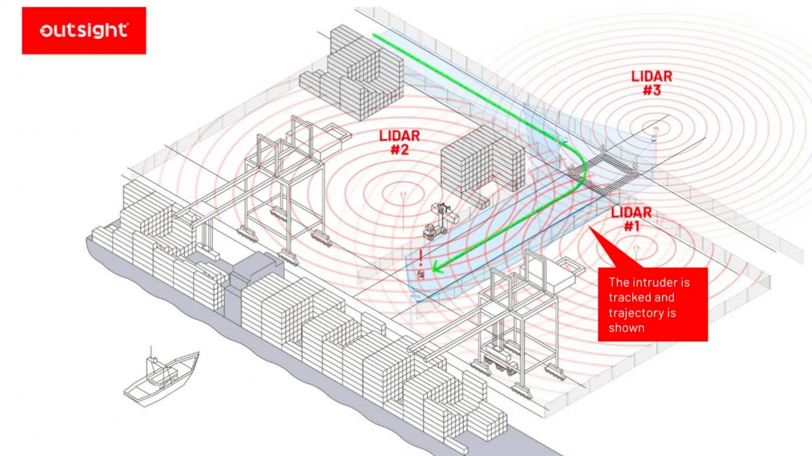
By integrating several LiDAR sensors strategically placed within the facility, this security solution can recognize and track intruders over an entire sensitive location, as opposed to merely perimeter fences like conventional security systems. In addition, it can also prevent reckless vehicles from entering vital facilities such as port terminals through tailgating.
Another possible security solution configuration is to use vehicle-based setup, by employing LiDAR sensors to collect point clouds from a moving platform and interpreting them using SLAM algorithms, available in Outsight’s LiDAR software.
Consider, as an illustration of the second scenario, how the Outsight LiDAR SLAM feature’s evaluation of elements through localization and perception provides harbor security.
Profiling Bulk Freight
When people are engaged to physically monitor the unloading of cargo from a ship at the port, not only is operational productivity diminished, but worker safety is also threatened.
LiDAR-based solutions offer promising resolutions due to their 3D environment scanning capabilities, dense point clouds, and 360-degree scanning range capabilities that could be used in this context.
Employees may find and determine the position of bulk materials using these capabilities, allowing operators to create the safe operation zones, transfer the grab bucket there, calculate the number of working rows, and estimate the grabbing times for a single row or layer.
With this information, personnel can observe the operating area with clarity and precision for completely automated unloading and smooth landing. All of this can be performed quickly and without endangering personnel using LiDAR systems.
Collision Avoidance and Navigational Systems
Port terminals are making increasing use of AITVs, or the Automated Inter-terminal vehicles, and AGVs, or the Automated Guided Vehicles, equipped with collision prevention and navigational systems.
These vehicles are equipped with LiDAR sensors that continually monitor the surrounding environment. If the sensor detects an object in the monitored region, the security system will sound an alarm (minimizing the chance of collisions between vehicles on the ground and nearby objects), and the vehicle will brake.
The LiDAR technology in these trucks aids in labor-saving and risk-free navigation assistance to keep cargo mobile around the port. It is resistant to all atmospheric conditions and requires no special infrastructure.
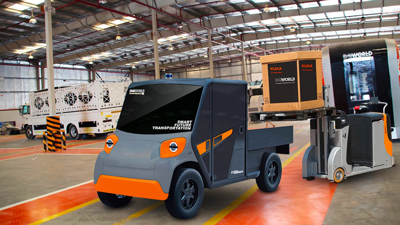
E-Trugo / Trugo project
Let us take a real-life example to prove how Outsight LiDAR solutions have been refining productivity and security at harbors.
DG World, one of Outsight’s clients, designed an Autonomous Intelligent Truck (TruGo) and an Autonomy Conversion Kit Solution that fit existing trucks, enabling 100% autonomy and flexibility.
TruGo is a fully connected solution and has been designed as the ultimate solution for port operations. There is also an electric version of the truck, called e-Trugo, to support gas emission reduction efforts.
The E-TruGo’s and TruGo’s technology is modular, and its secure system architecture makes it possible to handle different transmission configurations and engine types without requiring significant vehicle modifications.
Final thoughts
These are just a few of the possible applications in the port context of LiDAR-based systems, when equipped with the right processing software.
From terminal security to container handling and navigational examples, we saw that the potential applications of LiDAR solutions in ports involve many different industry segments and use cases.
LiDAR’s characteristics make it a perfect fit for this industry: it is a non-contact, remote sensing, 3D laser technology that can gather data at any time of day or in any weather, making the LiDAR-based system a trustworthy monitoring tool that balances safety, security, and efficiency.