Skip to content
Insights
The 5 Mega-trends Blowing in LiDAR Tails

The 5 Mega-trends Blowing in LiDAR Tails

Five long-term factors are driving the development of 3D perception technology and will therefore change a diverse set of industries all around the world.


It’s easy to lose sight of the big picture when, as a team, you’re focused on delivering short-term and concrete LiDAR software solutions to dozens of customers in a variety of industries, frequently adding new features (and fixing some bugs!): so let’s take a step back for a second and look at some macro-trends shaping the industry.

We’re witnessing the convergence of five long-term drivers propelling the advancement of 3D perception technologies.

Internal and LiDAR-specific trends such as commoditisation of hardware and the rise of software are correlated to these but are not the subject of this article - look at this one instead.

1. People and Goods’ flow Intelligence (while maintaining privacy)

Operators of both public and private spaces are under increasing pressure to ensure that people and products can move as efficiently as possible while simultaneously respecting the growing concerns for privacy.

The 5 mega trends blowing in lidar tails

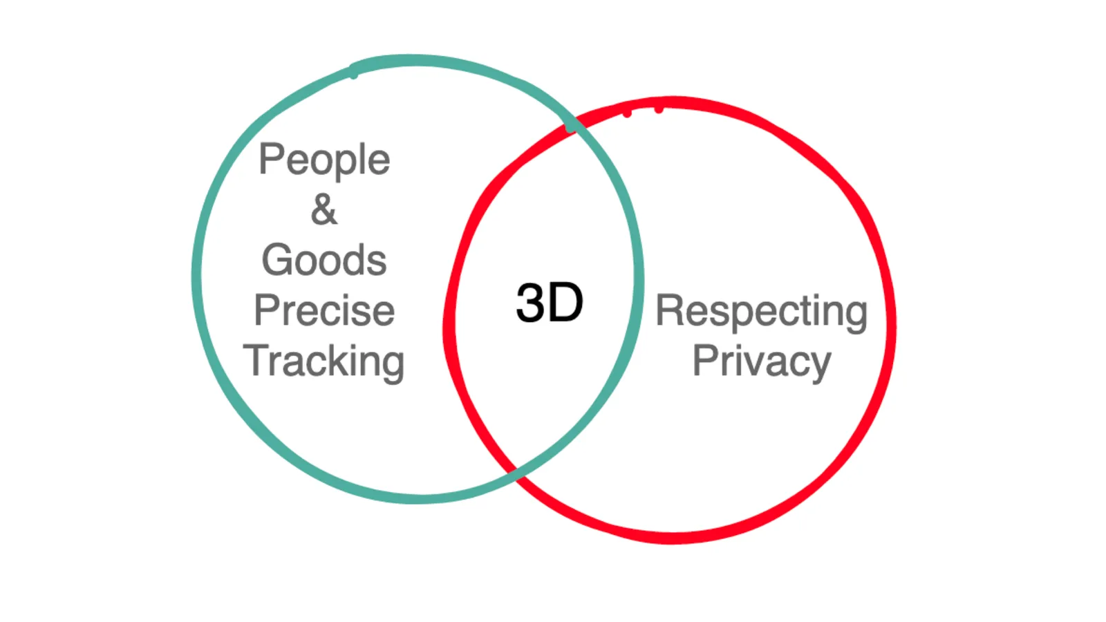
3D enables precise tracking of people and goods while respecting their privacy

For example, one of the major topics in the context of Smart City management is monitoring, understanding, and predicting city user behaviour (hottest places, trajectories, flows, and so on), so the delivery of city services can be improved (security, clean, transport,..).

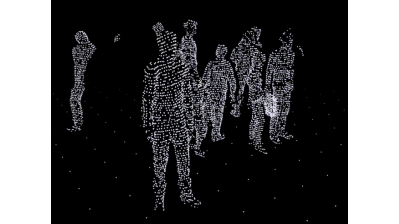
When used in private spaces, the goal is also frequently to improve operational efficiency, as demonstrated in one of our customers’ premises, where thousands of people are anonymously tracked in real time:

Point-cloud

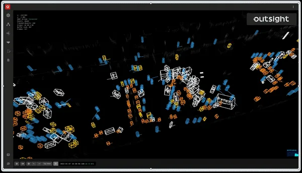
Anonymously tracking of people with LiDAR, processed by Outsight’s software

In the vast majority of cases, Personal Identification data is not really required because the questions to be answered are mostly about “where,” “when,” and “how many / how long,” and not so much about “who” (in the sense of an individual person).

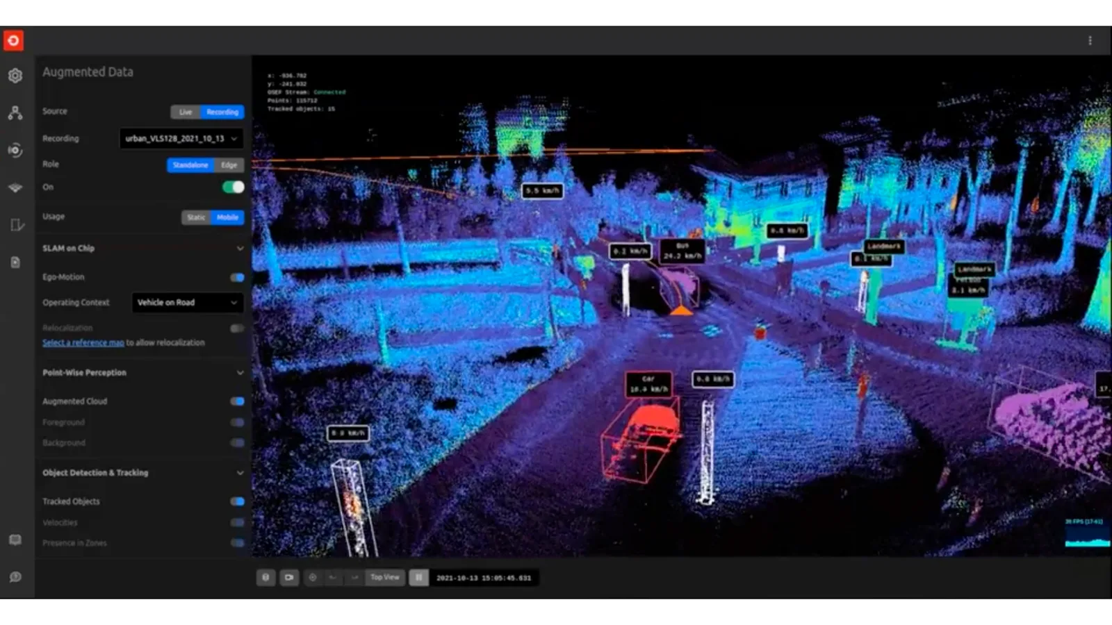
The need is to provide Spatial Intelligence: 3D LiDAR sensing (and soon Imaging Radar) provide the ideal raw data that can be processed by the right software to turn it into insightful and actionable information.

Unlike 2D images, these 3D natives sensors cannot capture personal identification information. They are a native privacy respectful solution:

The 5 mega trends blowing in lidar tails by outsight

LiDAR technology does not capture personal information.

2. Increasing Safety

Reducing accidents is commonly cited by LiDAR manufacturers as one, if not the most important, benefit of perceiving the world in 3D, whether in the context of fully autonomous driving or ADAS (Advanced Driver Assistance Systems).

The 5 mega trends blowing in lidar tails - ADAS

3D perception embedded in vehicles is not the only way to achieve this: we’re also seeing more and more initiatives aimed at eliminating traffic deaths by making the city’s infrastructure smart, such as the Vision Zero initiative from the City of Bellevue, Washington, with whom we’re proud to collaborate alongside other partners like Amazon Web Services (AWS), Ouster, Sighthound, Inc., Advanced Mobility Analytics Group and Fehr & Peers.

However, the need for safer environments is not limited to roads and cars, it is a much broader trend in the workplace: for example, in the United States alone, forklift accidents in warehouses and factories result in 34,900 serious injuries.

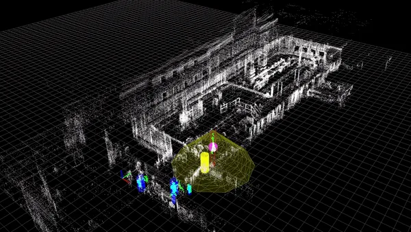
Many other situations, such as the safety around or under cranes on construction sites and in factories, can be handled thanks to 3D Sensing’s unique capabilities:

The alb augmented lidar box

3. The rise of the (mobile) robots

Recent advancements in batteries, processing power, and sensors (including 3D LiDAR), as well as population aging and worker shortages in western countries, are all converging at the same time to accelerate the deployment of robots in general industry including small and medium-sized businesses.

The 5 mega trends blowing in lidar tails - Robots

When combined with the right software processing, 3D perception will not only be an accelerator but also an enabler in many cases for automating tasks that fall under robotics’ own 3D (Dull, Dangerous, or Dirty) as well as many others that allow for increased productivity (e.g. e-commerce / logistics).

An example of a lidar application for pedestrian tracking

Market reports find that the market for mobile robots, drones, and autonomous vehicles in applications such as delivery and warehousing is likely to reach a staggering $81 and $290 Billion in 2030 and 2040, respectively.

4. The Metaverse (really?) & Digital Twins

We would have been skeptical if we hadn’t received several inquiries on the subject in the last few weeks from some of the biggest names in the industry, as interactions between the virtual and real worlds, including digital twin creation and update at massive scales, necessitate not only capturing reality in 3D but also doing so in real-time with the appropriate sensors and, more importantly, the appropriate software.

This appears to be less rooted in actual long-standing needs than the other mega-trends mentioned, but the momentum and overall investment in the subject make it difficult to ignore as it could have a significant impact on the 3D sensing market.

5. Climate change and sustainability

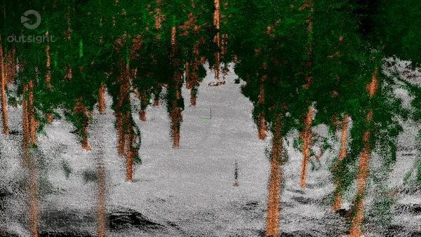
LiDAR for 3D remote sensing, primarily Airborne laser scanning, has been one of the most widely used methods by governments and institutions to collect environmental data for many years, including in the agricultural sector.

At Outsight we have some experience with these applications, having received one of Europe’s most prestigious awards, the Green Deal Award, as well as the French Environment Agency’s innovation award:

Ademe

LiDAR data creates a detailed 3D model of the area, including terrain, topography, and vegetation, that can be used for a variety of forestry and ecological applications.

Forestry management

You may find interesting this article on the subject:

Can Lidar Save the Earth?

Growing up, one of my most well-worn books was a copy of

Read article →

Getting a Better View of Landslide Risk With LiDARGeologists use LiDAR to try and figure out where landslides are more likely to occur.NC State NewsTracey PeakeDebris flow

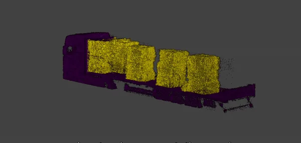
While dealing directly with natural resource conservation has a visible impact, other secondary activities, such as the recycling industry, will contribute significantly to the use of 3D sensing solutions like LiDAR.

We demonstrate how LiDAR can be used to automatically calculate the volume of a truck’s load leaving a recycling plant in the example below.

Truck measurement

Conclusion

For many, the self-driving car is how they learnt about LiDAR for the first time.

These five mega-trends demonstrate why this incredible technology is here to stay in an endless list of other applications, helping to make the world a smarter and safer place.

Contact a Product Specialist or if you want to know more!


Related Articles

AIRPORTS

Aeroporti di Roma to deploy Outsight's Physical AI solution at scale across Rome Fiumicino Airport

Aeroporti di Roma (ADR) is expanding its collaboration with Outsight to a large-scale deployment across almost all Schengen common-use areas at Rome Fiumicino Airport.

CORPORATE

Intel and Outsight Announce Strategic Collaboration to Bring Physical AI–Powered Spatial Intelligence to the Enterprise Edge

Outsight’s Shift platform integrated into Google Distributed Cloud Edge powered by Intel Xeon 6 SoC – Live demonstration at Google Cloud Next 2026

Let's connect

Send us a Message

Drop your email and we'll get back to you as soon as possible.

Frequently Asked Questions

  • Which industries outside automotive are actually deploying LiDAR for safety today?

    Warehouses and factories are among the clearest non-automotive adopters: forklift-related incidents in US facilities alone account for roughly 34,900 serious injuries per year, making proximity sensing a concrete operational need rather than a speculative one. BMW and other manufacturers have deployed infrastructure-based LiDAR systems, including through Outsight's SHIFT platform, to monitor worker-vehicle proximity on the factory floor without capturing biometric data. Construction sites use 3D sensing around cranes and under suspended loads, where camera-based systems struggle to produce reliable depth data in cluttered, high-contrast environments. City infrastructure is a third domain, with municipalities pursuing Vision Zero-style programs that instrument intersections rather than individual vehicles; the City of Bellevue is one example of this approach applied at the urban scale.

  • How does LiDAR support digital twin creation compared to photogrammetry?

    Photogrammetry derives 3D geometry from overlapping 2D photographs and produces high-texture static models, but requires controlled lighting and post-processing time measured in hours or days. LiDAR emits its own laser pulses and returns depth data at sensor frame rates, which makes real-time or near-real-time scene capture possible without ambient light dependency. For a digital twin that needs to reflect current physical state rather than a one-time survey, the continuous update cadence that LiDAR enables is the structural difference between a live replica and a periodic snapshot. Outsight builds on this property through its Motional Digital Twin, an infrastructure-based approach that uses LiDAR sensors to maintain a continuously updated 3D replica of how people, vehicles, and robots move through a site, with an end-to-end pipeline operating under 50 milliseconds.

  • Can LiDAR be used for environmental monitoring and forestry management?

    Airborne laser scanning has been a standard government and research method for environmental data collection for decades. The resulting 3D point clouds capture terrain, topography, and vegetation structure at resolutions that satellite imagery cannot match, supporting applications from landslide risk mapping to forest biomass estimation. Ground-based and mobile LiDAR extends this to finer-scale forestry work, including individual tree measurement and canopy gap analysis. Secondary environmental use cases include industrial recycling, where LiDAR can measure truck-load volumes automatically without contact. More broadly, the maturing of LiDAR software is pushing the technology into built environments as well: Outsight, for instance, applies infrastructure-based 3D LiDAR perception across airports, factories, and smart-city intersections through its SHIFT platform, illustrating how the same point-cloud fundamentals that serve forestry science are scaling into real-time operational settings.

  • Why does people flow analytics not usually need to identify individuals?

    Most operational questions about crowd and pedestrian flow are aggregate or trajectory-based: where do people go, how long do they wait, which routes are congested? Answering those questions requires tracking unique entities across space and time, but not linking those entities to names, faces, or credentials. This is why LiDAR-based systems like Outsight's Motional Digital Twin are anonymous by definition, capturing shape and motion without ever recording faces or biometric data. Individual identity becomes relevant only in a narrow set of workflows, such as security investigations or personalized service delivery, that are handled by separate identity-bound systems. For the large majority of flow-optimization and capacity-planning use cases, anonymous tracking produces the same actionable output at lower regulatory risk.

  • What role does imaging radar play in spatial sensing compared to LiDAR?

    Imaging radar operates at longer wavelengths than LiDAR and can penetrate precipitation and certain materials that scatter laser light, giving it an advantage in severe weather at longer ranges. Its angular resolution is currently lower than solid-state or spinning LiDAR, which limits fine-grained object classification at short to medium distances. In infrastructure sensing, the two technologies are increasingly treated as complementary inputs: LiDAR provides the high-resolution spatial backbone for object tracking and classification, while imaging radar can extend range or fill specific gaps. Outsight's SHIFT platform is built around a LiDAR-native pipeline with multi-vendor hardware compatibility, positioning it to incorporate additional raw-data sources such as imaging radar as the technology matures and infrastructure deployments grow more demanding.

  • How is population aging in western countries connected to robot deployment in factories?

    Declining working-age populations in Europe, Japan, and parts of North America are reducing the available labor pool for physically demanding or repetitive industrial roles. This structural shortage raises the cost of human labor and makes the payback period on robotic automation shorter, accelerating adoption timelines that would otherwise wait for sensor or battery technology to mature further. The effect is most visible in logistics and e-commerce fulfillment, where picking, sorting, and transport tasks have historically been labor-intensive and are now priority targets for autonomous mobile robot deployment. As robot density on factory floors rises, operators also need infrastructure-level awareness of how those robots and human workers share the same space, an area where Outsight's Motional Digital Twin, already deployed at BMW and other automotive manufacturers, provides real-time 3D tracking to support safer, more efficient human-robot coexistence.