Skip to content
Insights
Ouster and Outsight partner to expand digital LiDAR use in smart cities and industrial automation.

Ouster and Outsight Accelerate Digital Lidar Adoption

The combination of lidars and pre-processing software allows 3D perception to be integrated into industrial automation and smart infrastructure application


SAN FRANCISCO & PARIS–(BUSINESS WIRE)–Ouster, a leading provider of high-performance digital LiDAR sensors, and Outsight announced today the first integrated solution in the LiDAR industry with embedded data processing software.

This plug-and-play system is designed to deliver real-time, processed 3D data and designed to be integrated into any application within minutes. The solution combines Ouster’s high-resolution digital lidar sensors with Outsight’s perception software which detects, classifies, and tracks objects without relying on machine learning.

Ouster invented digital LiDAR technology in 2015 with a vision of making high-performance, ubiquitous, and affordable lidar-powered solutions across numerous industries.

With a similar goal in mind, Outsight invented the point-cloud data processing software to make 3D lidar easier than ever to use.

The combination of these two industry-leading products results in an end-to-end solution that delivers robust, usable data to customers while accelerating their time-to-market and decreasing product development costs.

“Ouster and Outsight’s strategic partnership represents our shared vision for making 3D lidar-powered solutions that are useful, simple, and affordable for every customer in every industry,” said Cyrille Jacquemet, general manager of Europe and the Middle East at Ouster. “We believe Ouster’s high-resolution lidar and Outsight’s unique 3D LiDAR Data processing software will allow customers to fully leverage LiDAR data in any application. Together, we are advancing safe, ubiquitous autonomy with this comprehensive solution.”

“By teaming up with Ouster, we created the first one-stop-shop for a comprehensive perception solution,” said Sebastien de la Bastie, Chief Business Officer at Outsight. “Our integrated kit has the right versatility for R&D experimentation and the right performance, robustness and scalability for large, real-world deployments. Together, we fill the gap between both worlds and dramatically accelerate customer’s time-to-market.”

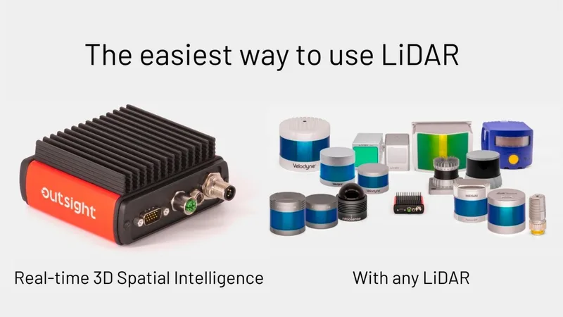
All-in-one solution: 3D digital lidar sensors with real-time data processing software

Ouster brings advanced 3D vision to diverse applications where real-time 3D perception, reliability, and 360-degree monitoring are required. Designed to IP68 and IP9K standards, Ouster’s sensors are built to withstand extreme weather conditions.

Ouster’s 3D lidar data is processed in real-time by Outsight’s edge compute system, an ARM-based compute node that functions as an integrated lidar box. Customers can receive both the raw, high-resolution point cloud data, which ranges from individual object information (position, trajectory, velocity) to aggregated analytics (object counts, flow patterns).

Further, Outsight’s proprietary Spatial AI-driven algorithms can accurately detect, track, and classify objects without any kind of training or data labeling.

This not only reduces customers’ applications power consumption and bandwidth requirements, but also allows customers to be up and running with the solution almost immediately and without any need for long data annotation processes.

This solution is already commercially available in Europe for industrial automation and smart city applications.

Looking ahead: bringing 3D LiDAR-based technology to all industries

Together, Ouster and Outsight are accelerating safe, ubiquitous autonomy with plug-and-play solutions that are useful, reliable, and easy to integrate across all industries.

This partnership is a part of an ongoing joint effort to bring 3D perception capabilities to every industrial robot, crane, traffic light, and any other moving and fixed objects.

The companies plan to extend the partnership to collaborate on additional solutions in numerous industries, including robotics and industrial vehicles.


Related Articles

AIRPORTS

Aeroporti di Roma to deploy Outsight's Physical AI solution at scale across Rome Fiumicino Airport

Aeroporti di Roma (ADR) is expanding its collaboration with Outsight to a large-scale deployment across almost all Schengen common-use areas at Rome Fiumicino Airport.

CORPORATE

Intel and Outsight Announce Strategic Collaboration to Bring Physical AI–Powered Spatial Intelligence to the Enterprise Edge

Outsight’s Shift platform integrated into Google Distributed Cloud Edge powered by Intel Xeon 6 SoC – Live demonstration at Google Cloud Next 2026

Let's connect

Send us a Message

Drop your email and we'll get back to you as soon as possible.

Frequently Asked Questions

  • What does a plug-and-play LiDAR perception kit actually include?

    A plug-and-play LiDAR perception kit typically bundles a hardware sensor, an edge compute node running pre-processing software, and a documented API that emits structured outputs: per-object position, trajectory, and velocity, plus aggregated analytics such as counts and flow patterns. The edge node handles detection, classification, and tracking locally, so the downstream application receives usable data rather than a raw point cloud requiring separate processing infrastructure. Outsight's SHIFT platform follows this model, pairing LiDAR hardware from vendors including Ouster with an on-site processing layer that delivers anonymous 3D object data in under 50 milliseconds, ready for integration into industrial automation or smart infrastructure systems.

  • Why does LiDAR perception software not need machine learning training data?

    Classical 3D geometry algorithms can resolve shape, size, and motion directly from point cloud geometry without labeled examples. A sphere of points moving at 1.4 m/s with a human-scale bounding box is a pedestrian by physics alone. Outsight's SHIFT platform is built on this principle: because the Motional Digital Twin derives identity and behavior from spatial geometry rather than learned visual patterns, it requires no site-specific training data to achieve consistent accuracy. This matters for industrial deployments because it eliminates the data-annotation cycle that typically adds weeks or months to a project timeline, and the system performs at accuracy levels that are independent of whether training data from that specific site ever existed.

  • What IP rating do outdoor industrial LiDAR sensors need for factory or street use?

    IP68 covers sustained immersion in water, while IP69K (sometimes written IP9K) covers high-pressure, high-temperature washdowns. Both ratings together are the threshold commonly specified for sensors deployed in outdoor industrial environments, including factory floors subject to wash cycles and roadside smart-city installations exposed to weather. A sensor meeting both standards can operate continuously in rain, pressure cleaning, and dust without ingress protection degrading over time. Outsight's infrastructure-based deployments at sites such as BMW factories and smart-city intersections rely on LiDAR hardware that meets these combined ingress standards, since the sensors are fixed in the infrastructure and must maintain reliable 3D perception across harsh operating conditions without interruption.

  • How does edge computing change the bandwidth requirements for a LiDAR deployment?

    A single 3D LiDAR sensor can generate hundreds of megabits per second of raw point cloud data. Running perception algorithms at the edge, on an ARM-based compute node co-located with the sensor, compresses that stream to structured object metadata: a few kilobits per second per tracked entity. Outsight's SHIFT platform applies exactly this architecture, processing raw LiDAR point clouds through a sub-50ms end-to-end pipeline and outputting anonymous object tracks rather than raw sensor streams. This reduction makes LiDAR practical over standard network infrastructure and removes the need for a dedicated high-bandwidth backhaul to a central server, which is a significant cost factor in smart-city and multi-sensor industrial deployments such as airports and factories.

  • What is the difference between a LiDAR hardware partnership and a software-only LiDAR integration?

    A software-only integration means the perception stack runs on general-purpose hardware the customer already owns, and calibration, latency tuning, and firmware compatibility remain the customer's responsibility. A hardware partnership produces a pre-validated, co-engineered bundle where sensor firmware and processing software are tested together before shipment. The practical difference shows up in time-to-deployment: a pre-validated bundle can be operational within minutes of installation, while a software-only approach requires a bring-up period that can extend the project schedule by days or weeks. Outsight's partnership with Ouster follows the hardware-partnership model, combining Ouster digital LiDAR sensors with the SHIFT platform into a co-validated stack that allows industrial automation and smart infrastructure operators to reach full 3D perception capability faster and with fewer integration unknowns.

  • Can a LiDAR system track both moving vehicles and stationary objects at the same time?

    Yes. 3D LiDAR point clouds contain every surface in the sensor's field of view on each scan cycle, whether moving or stationary. Perception software segments the scene into dynamic entities (vehicles, pedestrians, robots) and static background (walls, parked equipment, infrastructure). Both are available simultaneously: dynamic entities receive trajectory and velocity attributes, while static objects are registered as occupancy mesh. Outsight's SHIFT platform applies exactly this dual-output approach, processing the full scene in real time through a sub-50ms pipeline and feeding the results into a Motional Digital Twin that reflects both live movement and fixed spatial context. This capability is what makes the technology applicable to mixed environments such as factory floors, where autonomous vehicles share space with fixed machinery and on-foot workers, as seen in deployments at BMW and other industrial facilities.