Skip to content
Insights
Outsight’s LiDAR view tracking people anonymously as they move through passport control.

People Flow Monitoring 2.0: How LiDAR solutions outperform other technologies

LiDAR solutions' accuracy and versatility make them a superior solution and will undoubtedly lead to improved safety and efficiency in high-traffic areas.


Thanks to how fast the technology has evolved during the past decade, today, we have several solutions for measuring queues and counting passengers at public spaces and transportation hubs like airports, train and bus stations.

With the expressive number of technological solutions available, it’s important to have a clear idea of what each one can do and how it can be used.

LiDAR solutions are a promising option for public areas seeking an effective and flexible solution without breaking the bank.

Check out an example about how airports are leveraging Outsight software for managing people flow:

LiDAR Manages Increased Airport Traffic

See how and why Airports are increasingly using LiDAR-based software solutions to tackle their biggest challenges, leveraging the unique value of Spatial Intelligence.

Read article →

The Need for Continuous Measurements

The technological solutions for measurement projects have been transformed to extraordinary lengths. In addition, the COVID-19 pandemic intensified our concern about social distancing and crowd density. So, counting people and measuring how long they wait in line have become very typical in many use cases.

Unfortunately, this process is slowed down by the cost of installation and technical limitations, such as data privacy concerns and large areas coverage.

LiDAR solutions are an excellent option because they don’t gather any private data and meet GDPR requirements.

Computer screen displaying a LiDAR scan - showcasing the superiority of LiDAR solutions in People Flow Monitoring 2.0.

Additionally, LiDAR software can combine multiple LiDARs output to cover vast areas with high measurement precision. This means all collected 3D LiDAR data can be analyzed using tools to identify and improve behaviour patterns, thus improving management decisions.

Typical Tracking and Measurement Technologies

Several technologies have been already tested for different use cases.

We get into the details in this article about LiDAR vs Camera vs Radar :

A detailed comparison of LiDAR, Radar and Camera Technology

This article explores the capabilities and limitations of each type of sensor, to provide a clear understanding of why LiDAR has emerged as a strong contender in computer vision tech race.

Read article →

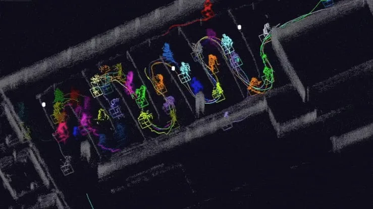
How does LiDAR solutions work?

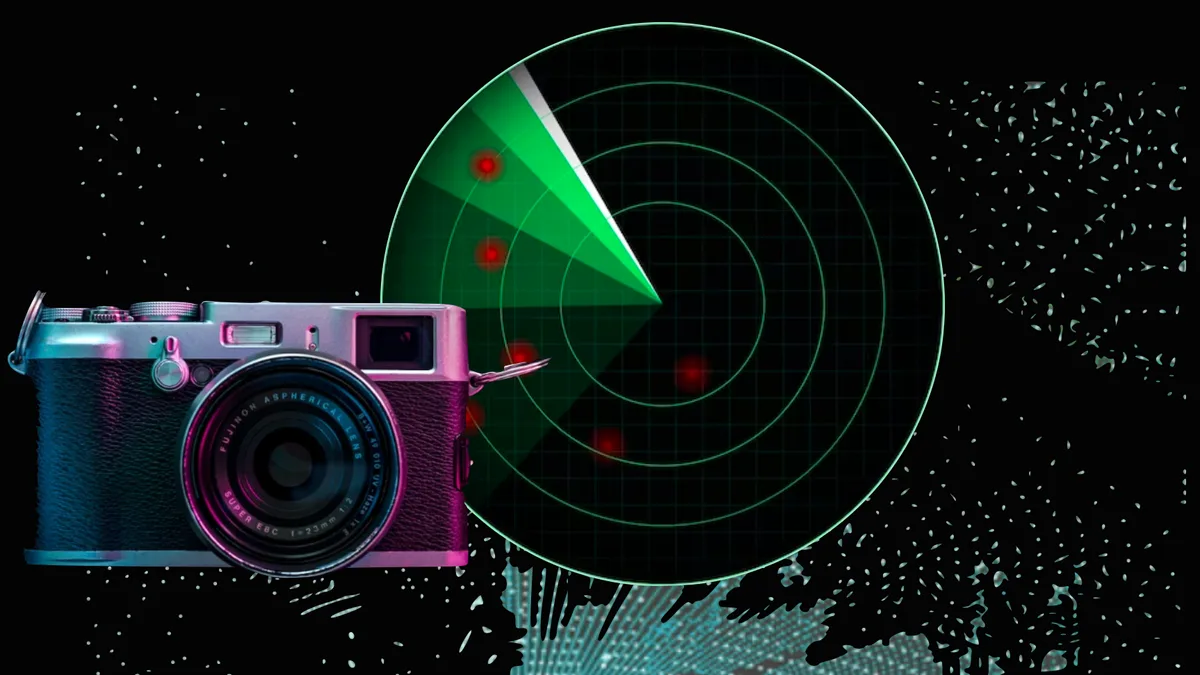
LiDAR technology, to some extent, is similar to Radio Detection and Ranging (RADAR) technology. However, instead of radio signals, the LiDAR sensor sends laser beams and collects the rays reflected by the objects.

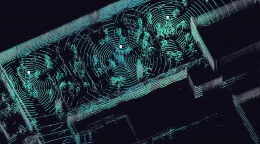
The distance towards the objects is measured by calculating the time it took the reflected laser beams to hit back at the sensor. The spectrum of reflected laser beams creates a “3D point cloud” of a specific area, which is the source data for consecutive object recognition and analysis, made by software like Outsight’s.

Learn more in our article about what is LiDAR :

Understanding the basics of 3D LiDAR Technology

Light Detection and Ranging, also known as LiDAR, is a technology for remote sensing that is used to measure distances in an environment.

Read article →

LiDAR sensors alone cannot solve particular business problems. The software layer must be added to the system to further process sensor data in order to perform certain tasks like object identification or tracking.

This 3D perception layer is crucial to processing LiDAR data and running tasks like point-cloud filtering and conditioning, sensor aggregation (when we have more than one sensor capturing data), object detection, and so on.

The final step requires further processing to meet particular business challenges by computing actionable KPIs and showing them on a dashboard.

For example, if the objective is to calculate the queue waiting duration in a store, the software will detect and track people while identifying whether they belong to a particular queue. It will then run statistics on the processed data and present them in an easy-to-digest format.

The Advantages of LiDAR solutions

While LiDAR technology by itself isn’t a modern-day gold mine, LiDAR solutions can enhance the measurement process of people flow more efficiently than typical queue measurement tools based on cameras with a limited view horizon.

LiDAR sensors also have a broad field of view with a range of up to 200 meters, allowing LiDAR solutions to detect longer lines even if they go outside of the designated areas.

Besides, an installation of LiDAR solutions is less expensive than others in a greenfield situation because of the optimization of the number of sensors, especially in places with low ceilings where dozens of cameras are needed to cover the area.

How Outsight Powers Scalable Yet Cost-Effective Projects

To successfully carry out a LiDAR measurement project, one must clearly assess the measurement and detection installation use cases.

Thanks to Outsight’s expertise in LiDAR technology solutions and the benefits and problems of different setups, whether associated or not with other types of cameras, Outsight’s team can provide knowledge to successfully deploy a spatial intelligence solution in any setup.

One of the main reasons behind is that Outsight software frees you from being tied to a single manufacturer or type of hardware.

Outsight helps customers that need people flow monitoring solutions integrate the most advanced sensor technology without vendor lock-ins. The platform also makes it easier to scale up and brings down costs. This is because the different sensor combinations guarantee the best solution for each use case.

With the use of Outsight’s simulator, we help our customers choose the best LiDAR sensor, its quantity and locations to minimize costs and maximize accuracy


Interested? Contact us to learn more about how we can help achieve your tracking and measurement goals at airport facilities by leveraging advanced LiDAR technology solutions


Related Articles

AIRPORTS

Aeroporti di Roma to deploy Outsight's Physical AI solution at scale across Rome Fiumicino Airport

Aeroporti di Roma (ADR) is expanding its collaboration with Outsight to a large-scale deployment across almost all Schengen common-use areas at Rome Fiumicino Airport.

CORPORATE

Intel and Outsight Announce Strategic Collaboration to Bring Physical AI–Powered Spatial Intelligence to the Enterprise Edge

Outsight’s Shift platform integrated into Google Distributed Cloud Edge powered by Intel Xeon 6 SoC – Live demonstration at Google Cloud Next 2026

Let's connect

Send us a Message

Drop your email and we'll get back to you as soon as possible.

Frequently Asked Questions

  • What is the difference between people counting and people flow monitoring?

    People counting produces a single integer: how many individuals crossed a line or occupied a zone. People flow monitoring produces continuous trajectories, with each person tracked from entry to exit and attributes such as speed, direction, dwell time, and queue membership recorded frame by frame under a persistent anonymous ID. The distinction matters operationally because a count tells a manager how busy a checkpoint is, while a flow trace reveals why it slowed down, where upstream congestion started, and whether the same delay recurs at a structural level. Outsight's Motional Digital Twin is built around this second, richer layer, generating real-time anonymous 3D trajectories across sites like Paris-Charles de Gaulle airport and SNCF train stations to support exactly that kind of structural flow analysis.

  • Can a LiDAR people-monitoring system work in venues with very low ceilings?

    Low ceilings are actually advantageous for LiDAR coverage. A single ceiling-mounted sensor at 3 to 4 meters height can cover a wide floor area because the sensor's field of view sweeps a large horizontal cone close to the ground. Outsight's infrastructure-based approach, used in deployments across train stations operated by SNCF Gares & Connexions in France, relies on exactly this geometry: sensors mounted in the infrastructure overhead capture precise 3D shape and motion data across dense crowd environments without any loss of accuracy at reduced heights. In contrast, camera-based systems at low ceiling heights suffer from severe perspective distortion and occlusion when crowds are dense, requiring many more units per square meter to achieve comparable coverage.

  • Does LiDAR people monitoring meet GDPR requirements without additional configuration?

    LiDAR sensors emit laser pulses and measure the geometry of reflected surfaces. The resulting 3D point cloud encodes shape, position, and motion but contains no pixel data, so faces, skin color, and identifying features are physically absent from the raw capture. Because no personal data is recorded in the first place, there is no anonymization step required to achieve GDPR compliance: the system satisfies the regulation by the nature of the sensor, not by a post-processing filter that could be misconfigured or disabled. Outsight describes this property as "anonymous by definition," a core characteristic of its infrastructure-based LiDAR deployments at sites such as Paris-Charles de Gaulle and SNCF train stations, where the Motional Digital Twin tracks people flow without ever capturing biometric data.

  • How does sensor fusion work when multiple LiDAR units cover the same space?

    Each sensor produces its own 3D point cloud referenced to a local coordinate frame. A software layer re-projects every sensor's output into a single shared coordinate system, then merges the overlapping point clouds into one unified scene. Objects that appear in two sensors' fields of view are deduplicated rather than double-counted. Outsight's SHIFT platform applies this fusion logic across multi-vendor LiDAR hardware (including Hesai, RoboSense, and Ouster units) within a sub-50ms end-to-end pipeline, so the merged scene stays current in real time. The result is that a person walking from one sensor's zone into another carries the same anonymous tracking ID continuously, with no gap or handoff artifact in the data stream.

  • What happens to people-monitoring accuracy when a tracked person stops moving for an extended period?

    Stationary objects are among the more demanding edge cases in 3D perception pipelines. A person standing still produces a static point cluster that can be misclassified as furniture or infrastructure between frames. Robust software addresses this by maintaining the entity's ID and bounding box across a configurable timeout window, cross-referencing the cluster's shape signature against the known floor plan, and reactivating the trajectory when motion resumes. Outsight's Motional Digital Twin handles exactly this scenario by processing point cloud geometry in real time, at sub-50ms latency, so a motionless person retains a persistent identity rather than being dropped from the scene model. Dwell-time KPIs depend directly on this capability, because the system must distinguish a person standing in a queue from a fixed object to produce reliable occupancy and flow analytics.

  • What output format does a LiDAR people-monitoring platform expose for downstream integration?

    After the 3D perception layer classifies and tracks entities, the data is typically surfaced through a documented API as a structured event stream: per-entity records carrying a timestamped position, bounding box, classification label, and behavioral state. Outsight's SHIFT platform follows this model, exposing open integrations so operators can connect the Motional Digital Twin to existing operations platforms without proprietary lock-in. Aggregated KPIs (zone occupancy counts, queue lengths, average dwell times) are delivered separately on configurable intervals, ranging from sub-second for live alerting to hourly or daily for analytics dashboards. Standard integration targets include REST endpoints, MQTT brokers, and WebSocket connections, covering the control-room displays, BMS systems, and data warehouses that airport and transit operators typically run in parallel.