Skip to content
Insights
Smart city with public transportation and pedestrian crosswalk perfect for ITS smart city lidar applications

LiDAR Software - an enabler for expanding ITS solutions

With the global rise of 3D sensor demand, LiDAR has never been so accessible and it’s becoming essential for Intelligent Transportation System applications.


Rapidly growing populations in metro regions worldwide have created new and pressing difficulties, such as increased road traffic, traffic-related deaths, and higher carbon emissions.

For reference, in 2019, congestion costs were estimated to be around EUR 110 billion a year in Europe (1) and USD 87 billion a year in the US (2). Car sales are also rising globally again after the pandemic, with an average growth expectation of 2% until 2030 (3).

These factors have highlighted more than ever the urgency and importance of multiplying intelligent transportation system solutions.

LiDAR technology, utilized in vehicle and pedestrian flow monitoring, has the potential to make our cities smarter and safer. This technology provides insights that help cities allocate resources more efficiently, reduce emissions, and decrease accident rates.

However, for flow monitoring to be impactful, it requires precise perception, situational awareness, and respect for citizens’ privacy, qualities where LiDAR technology excels.

Here is where LiDAR is to be considered among the most prominent technologies.

LiDAR sensors stand out by offering highly detailed, accurate spatial measurements. Unlike existing 2D-based perception technologies, such as cameras, the 3D data from LiDAR produces highly detailed, accurate spatial measurements (LiDAR sensors achieve centimeter-level accuracy) (4) and works in various environments and contexts, such as during the night or in direct sunlight.

Moreover, when deployed on a large scale, LiDAR systems ensure privacy as they do not capture personally identifiable information.

Lidar software an enabler for expanding its solutions

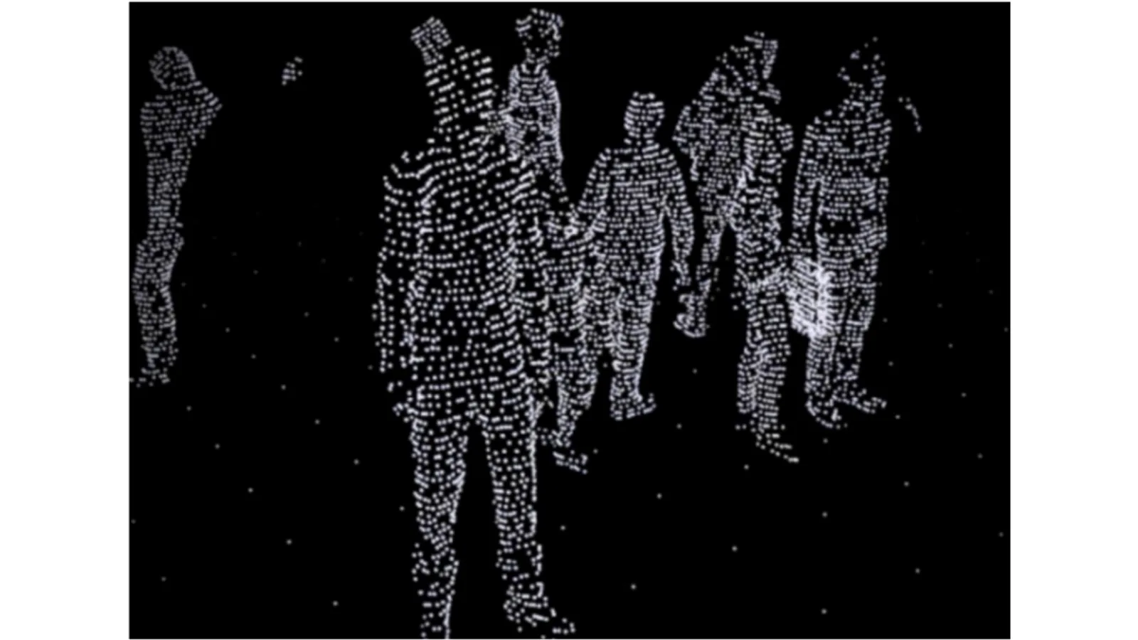
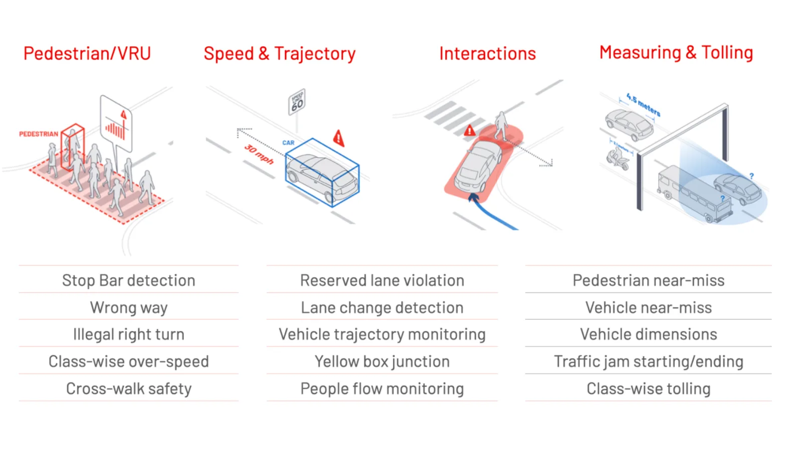
In the context of ITS solutions, LiDAR opens up many opportunities, including traffic monitoring, smart intersections, the detection of VRUs (5), near-misses events, and the increase in the overall safety of both vehicles and pedestrians.

Lidar software use cases for ITS

However, the adoption of LiDAR systems in these contexts is often hampered by the complexity of the data output, especially when integrating multiple LiDAR sensors in various orientations and configurations, sometimes even from different manufacturers.

This complexity is particularly relevant for smart traffic solutions, where tasks demand real-time processing at the edge, a challenge distinctly different from scenarios that allow longer post-processing times, such as mapping applications.

To address these challenges, the market now offers 3D LiDAR data preprocessors.

The first such preprocessor, the Augmented LiDAR Software introduced by Outsight in 2019, has become highly popular because it is compatible with any LiDAR and offers comprehensive, user-friendly features.

Key features of Lidar processing software

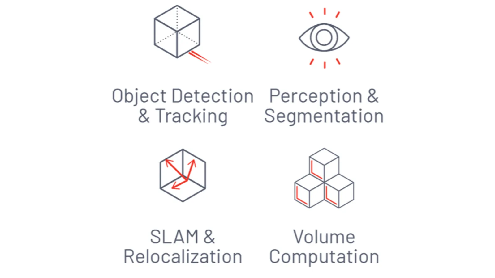
The software from Outsight can provide information about the volume, trajectory, and even the classification of objects that have been spotted, in addition to converting raw data into actionable data.

Explaining 3D LiDAR Preprocessors

The software behind this promising 3D technology

Read article →

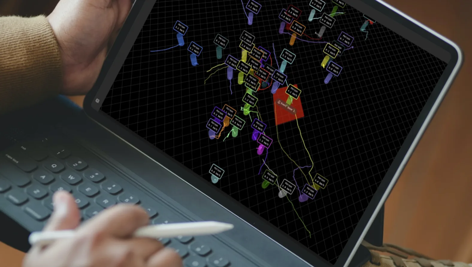
LiDAR preprocessors tackle these issues head-on, especially beneficial for ITS applications, as they convert voluminous 3D data into narrow-band data when processed alongside sensors at the edge. This conversion allows for efficient low-power wireless communication.

As a recent example, Outsight has provided systems to monitor and manage traffic intersections in some important US city centers, reducing the number of fatal and serious injury collisions in traffic to zero (6).

The next video details the most important steps behind this solution:

Major cities globally, such as New York City, Amsterdam, Stockholm, and Singapore, have already advanced their ITS capabilities, paving the way for others to follow suit.

In these scenarios, LiDAR solutions will undoubtedly accelerate the implementation of smart city initiatives thanks to their high precision, versatility, affordability, and ease of integration with the appropriate software.

If you want a consultation with one of our product specialists on how to start your Smart Traffic LiDAR-based application, you can do it by using this contact link.

Our mission at Outsight is to build the easiest and most efficient way to use 3D LiDAR data in any application.

With the use of our real-time preprocessing software, it has never been simpler to develop advanced 3D-based solutions for the maritime industry.


Sources:

1. ECA, “Urban Mobility in the EU”, April 2019

2. INRIX, “Congestion Costs Each American Nearly 100 hours, $1,400 A Year”, March 2020

3. Mckinsey, “Automotive revolution – perspective towards 2030”, January 2016

4. Source: Vectornav, LiDAR mapping

5. Vulnerable Road Users

6. City of Bellevue, WA - Transports, “Vision Zero”


Related Articles

AIRPORTS

Aeroporti di Roma to deploy Outsight's Physical AI solution at scale across Rome Fiumicino Airport

Aeroporti di Roma (ADR) is expanding its collaboration with Outsight to a large-scale deployment across almost all Schengen common-use areas at Rome Fiumicino Airport.

CORPORATE

Intel and Outsight Announce Strategic Collaboration to Bring Physical AI–Powered Spatial Intelligence to the Enterprise Edge

Outsight’s Shift platform integrated into Google Distributed Cloud Edge powered by Intel Xeon 6 SoC – Live demonstration at Google Cloud Next 2026

Let's connect

Send us a Message

Drop your email and we'll get back to you as soon as possible.

Frequently Asked Questions

  • How much does urban traffic congestion cost cities each year?

    Pre-pandemic estimates put the annual cost of road congestion at roughly EUR 110 billion across Europe and USD 87 billion in the United States, based on a 2019 European Court of Auditors report and a 2020 INRIX study respectively. Neither figure includes indirect costs such as healthcare spending on collision injuries, emissions-related health impacts, or productivity losses from unreliable freight delivery, so the true economic drag is likely higher. Addressing congestion at its source requires real-time visibility into how vehicles and pedestrians actually move through infrastructure. Outsight's Motional Digital Twin applies infrastructure-based 3D LiDAR perception to that problem, with deployments at signalized intersections such as those in the City of Bellevue's Vision Zero program, where anonymous, sub-50ms tracking supports the kind of data-driven traffic management cities need to reduce both congestion and its cascading costs.

  • What does a LiDAR preprocessor actually output compared to raw point-cloud data?

    Raw LiDAR point clouds stream hundreds of thousands to millions of 3D coordinates per second per sensor. A preprocessor compresses that into narrow-band structured data: tracked entity records carrying position, bounding-box dimensions, trajectory, classification, and behavioral labels. Outsight's SHIFT platform follows this model, reducing raw 3D sensor output to compact object-level streams through a sub-50ms end-to-end pipeline that runs on edge hardware rather than server-class processors. For roadside ITS deployments, where wireless backhaul bandwidth is constrained, that compression is essential. It also reduces edge compute requirements significantly, making large-scale infrastructure sensing practical without dedicated high-power processing at every node.

  • Why is real-time edge processing specifically important for smart traffic applications versus other LiDAR use cases?

    Traffic safety applications require decisions in fractions of a second: a pedestrian stepping off a curb, a vehicle running a red light, or a near-miss event unfolding in under two seconds. Post-processing pipelines that batch data and return results minutes later are adequate for mapping or urban planning surveys, but they cannot trigger live signals, alerts, or intersection management actions. Edge processing keeps latency below thresholds where intervention is still meaningful. Outsight's infrastructure-based approach addresses this directly, with a sub-50ms end-to-end pipeline that enables real-time situational awareness at intersections, as demonstrated in the City of Bellevue's Vision Zero smart-city deployment, where live 3D perception must respond to safety-critical events as they happen.

  • Can a single LiDAR sensor cover an entire intersection, or does full coverage need multiple units?

    A single sensor mounted at a standard pole height will have occlusion gaps: a large truck can block the sensor's line of sight to a cyclist on the far side. Full intersection coverage typically requires two to four sensors placed at complementary angles. When their point clouds are fused into one shared 3D scene, blind zones are eliminated regardless of vehicle mix or traffic density. The multi-sensor fusion step is what preprocessing software handles before any analytics logic runs. Outsight applies this exact approach in smart-city deployments such as the City of Bellevue's Vision Zero intersections, where the SHIFT platform fuses multi-sensor point clouds in real time, with a sub-50ms end-to-end pipeline, to deliver complete situational awareness across the full intersection geometry.

  • How does LiDAR-based traffic monitoring handle pedestrian privacy without additional data-protection controls?

    LiDAR sensors emit laser pulses and measure how they return from surfaces. The output is a set of 3D coordinates describing shape, size, and motion. No pixel data is captured, which means faces, clothing details, and license plates are physically absent from the data stream. This is the principle behind Outsight's approach: because the SHIFT platform is LiDAR-native, anonymity is a structural property of the sensor physics rather than a configuration option that could be misconfigured or reversed. Regulatory frameworks such as GDPR apply to personally identifiable information, and because no such information exists in the LiDAR output, compliance is an inherent consequence of how the data is collected, not a layer added on top of it.

  • What global cities are considered reference points for advanced ITS deployments?

    New York City, Amsterdam, Stockholm, and Singapore are commonly cited as benchmarks for mature intelligent transportation system infrastructure. Each has integrated sensor networks, centralized traffic management platforms, and active Vision Zero-style safety programs. Bellevue, Washington is a notable mid-size example: its LiDAR-based smart intersection program, documented under its Vision Zero initiative, reduced fatal and serious-injury collisions at monitored intersections to zero. Outsight's infrastructure-based Physical AI approach is deployed in Bellevue as part of that program, using the SHIFT platform to generate real-time 3D tracking of pedestrians and vehicles at monitored intersections without capturing any biometric or license-plate data.