Skip to content
Insights
3D LiDAR point cloud flowing through a software engine, representing real-time data processing and spatial intelligence.

What is a 3D LiDAR Preprocessor?

If LiDAR is such a desirable technology, why isn't it employed more often? The core issues preventing a wider adoption are solved by Software pre-processing.


From smart cities to autonomous machines, companies in both the public and private sectors are increasingly looking to leverage the benefits of 3D perception. Five mega-trends are propelling the technology.

Application developers are turning to 3D LiDAR either to replace legacy sensing technology or to create solutions that were once unachievable.

Unlike existing 2D-based perception technologies, LiDAR produces highly detailed, accurate spatial measurements and works in a range of environments and contexts such as during the night and under direct sunlight.

Take a look at this article to understand the basics of the technology:

Understanding the basics of 3D LiDAR Technology

Light Detection and Ranging, also known as LiDAR, is a technology for remote sensing that is used to measure distances in an environment.

Read article →

LiDAR also offers an important nontechnical advantage when deployed at scale: no personally identifiable information is ever captured.

What s a 3d lidar preprocessor by outsight -queue

Companies are always looking for ways to improve their operations and differentiate themselves, so what’s holding LiDAR back?

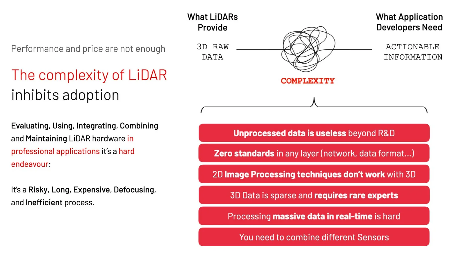
Contrary to what the majority of observers who are primarily focused on the automotive industry think, it’s not cost or performance that’s inhibiting a broader adoption of LIDAR.

Instead, it’s the complexity associated with this new technology.

Complexity of lidar

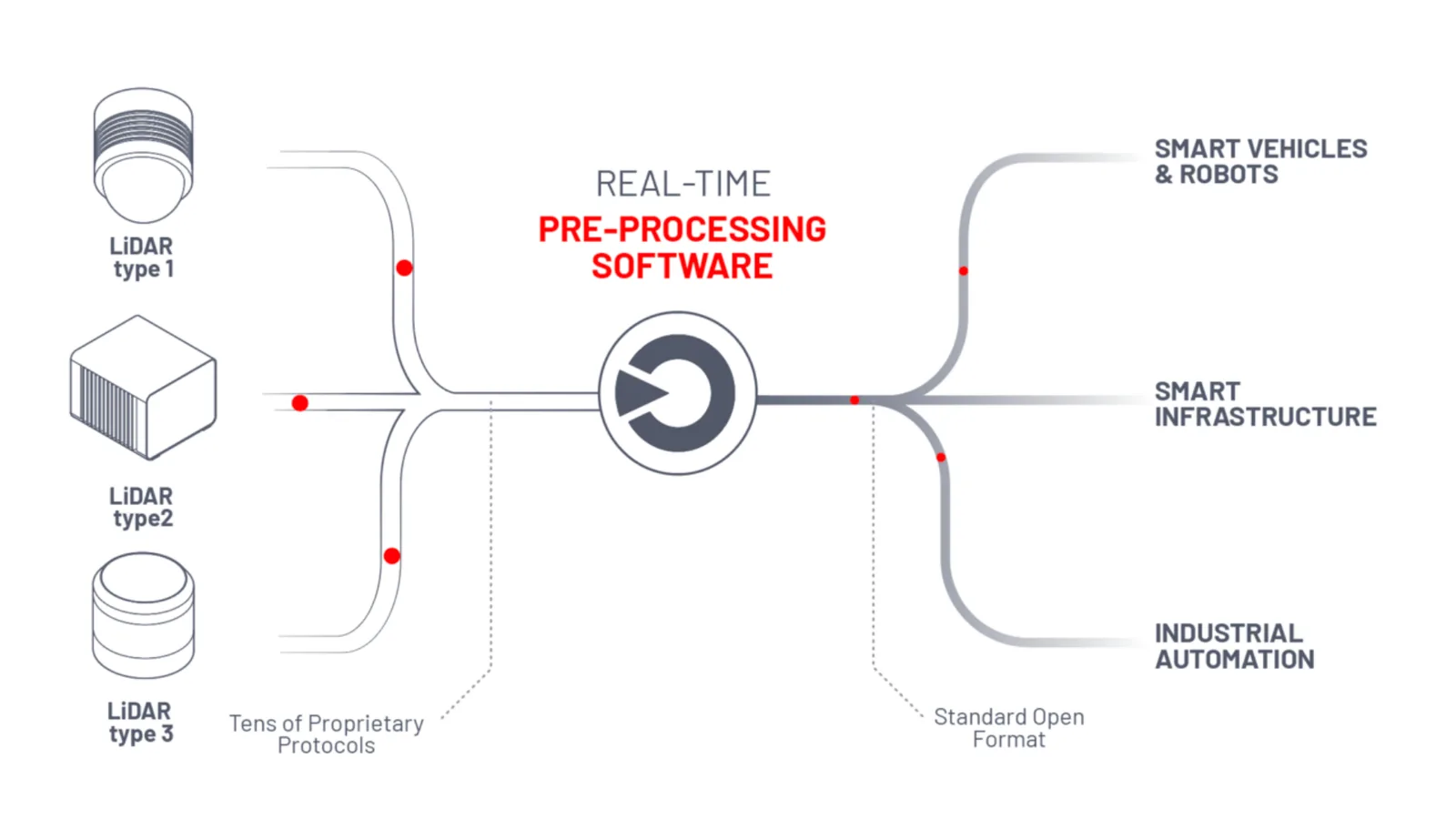
A 3D LiDAR Pre Processor turns RAW sensor data into actionable information

Running in real-time, LiDAR pre-processing software takes raw 3D data as an input and instantly converts it to accessible, actionable insight.

As its names indicates, a pre-processor doesn’t replace the application-specific software but facilitates and accelerates the development of LiDAR projects.

The software stack vs pre processor  - by outsight

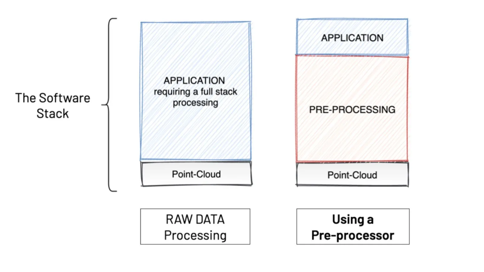
In general the software stack can be organized in 3 abstraction layers running on top of the basic point-cloud that the LiDAR hardware provides:

Three processing layers Detail of 3 layers processing

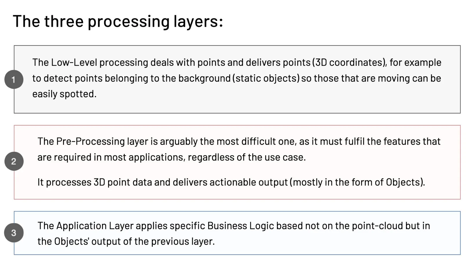
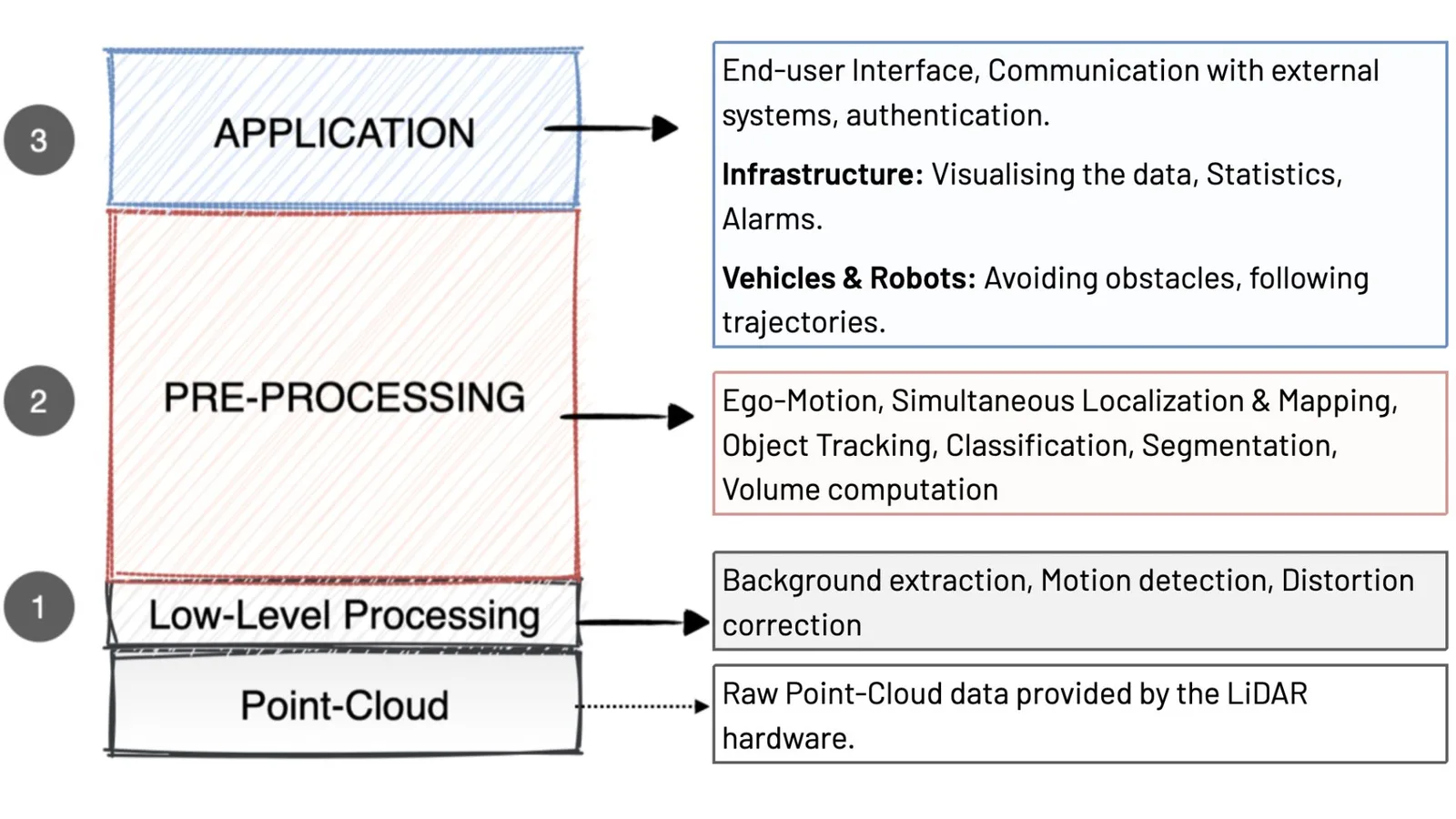
The overall objective of a LiDAR pre-processor is to make it super-easy to use and integrate this awesome technology.

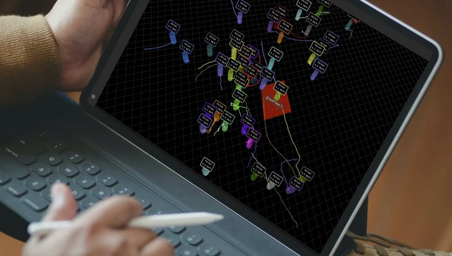
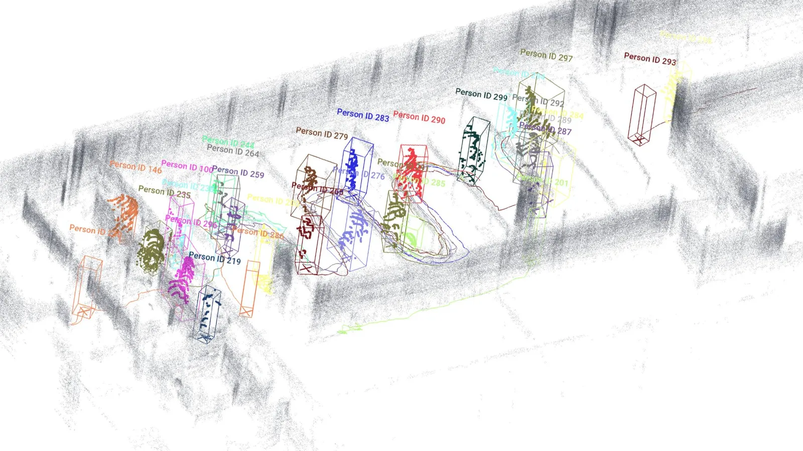
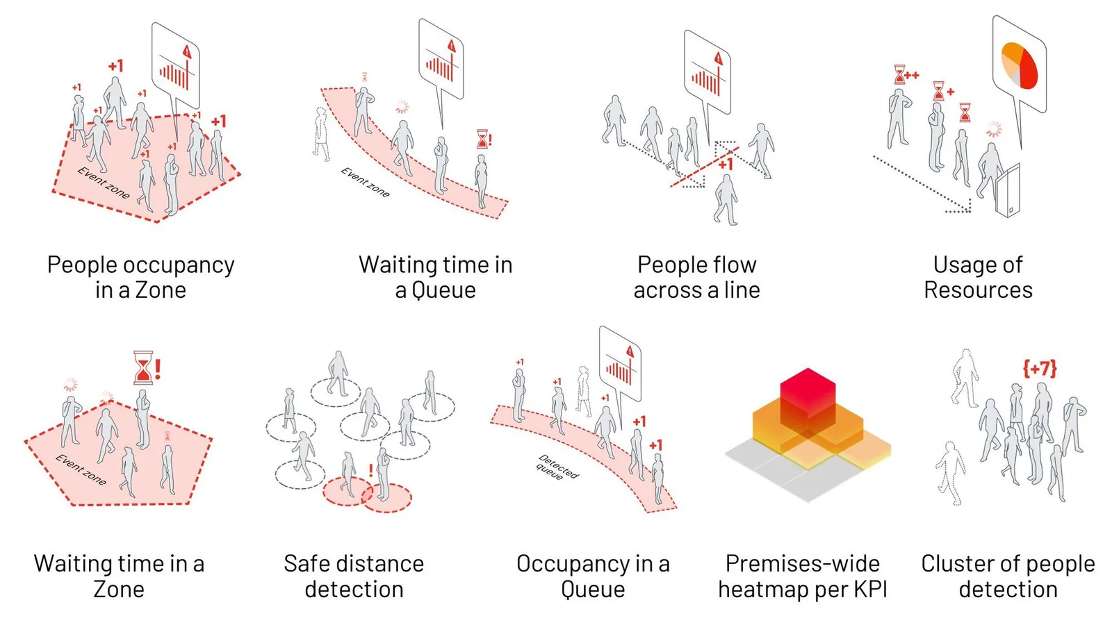
For example, in a People Flow Monitoring applications the Pre-Processing Layer will detect the persons and objects among all the other points returned by the LiDAR, and output their unique ID, Position, Size, Speed and Classification.

These are the informations required for the Analytics layer to generate meaningful KPI’s:

Airport kpis

Take a look at this other application in the context of Smart Cities, where the objective is to disminish accidents between vehicles and VRU (Vulnerable Road Users) in city intersections:

Outsight’s Comprehensive ITS Solution

Outsight provides the easiest and most comprehensive way to use LiDAR in ITS: from Simulation to Deployment and Analytics’ Dashboard.

Read article →

In a different context, starting using SLAM (Simultaneous Localization & Mapping) for mobile robotics & Smart Vehicles applications is now possible in a matter of seconds, without needing to install any framework or software in your computer:

In more detail, the four main functions that a Pre Processor performs simultaneously are:

1. Abstracting the Hardware complexity (input): this means that the application developer won’t have to worry about creating a unique driver for each Sensor, as well as adding features that allow data from different manufacturers to be fused (combined).

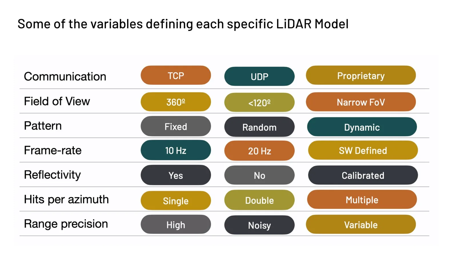
It’s easier said than done since there is no standard among manufacturers, in the network, transport nor application layer, and there are many different combinations to choose from :

Multiple lidars complexity variables

Outsight provides a LiDAR-agnostic software solution embedded in a plug and play Edge device.

A good Pre-Processor needs to be compatible with more than 90% of Lidar hardware manufacturers:

Compatible with all lidars

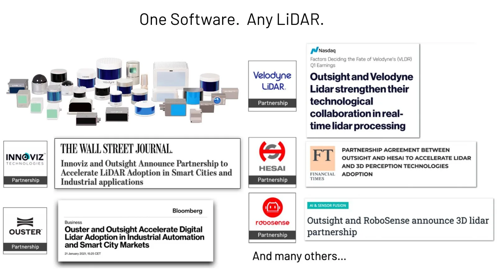
OUTSIGHT has built strategic partnerships with most of the LiDAR manufacturers

2. Standardising and simplifying the output: LiDAR proprietary data formats and protocols made sense when this emerging technology first appeared since it shortened the time to market of new hardware products delivering raw data. The burden of decoding each specific format was on the user.

For a LiDAR pre-processor to accomplish its purpose, it must provide an open data representation system.

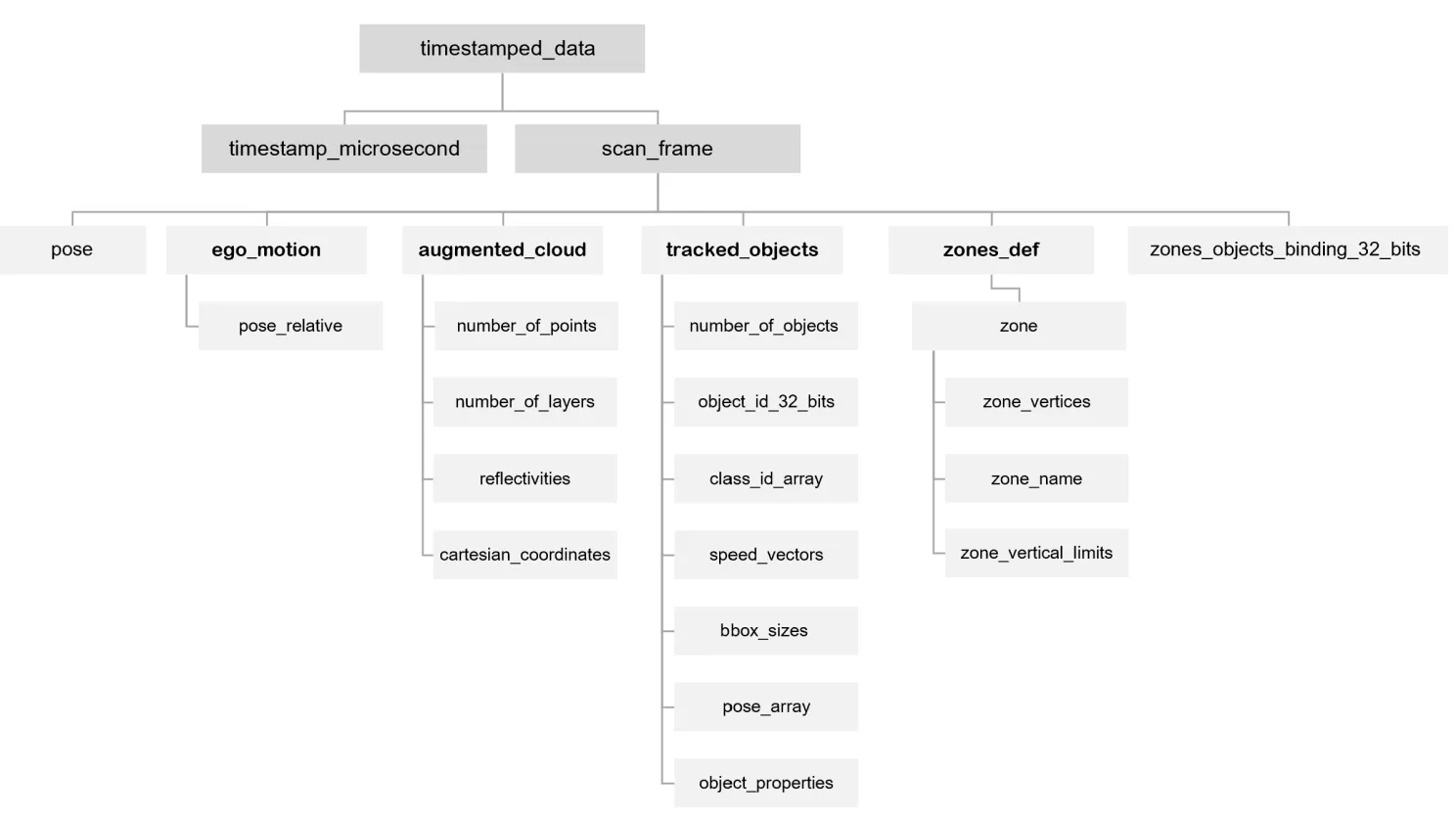
The Outsight’s Augmented LiDAR Box© delivers its output using OSEF, a serialisation binary format, based on TLV-encoding.

data format OSEF

You can learn more in this article about the 7 Attributes required for an Open Data format:

Key Features of Open Data for LiDAR

When choosing a 3D LiDAR processing software it’s important to ensure that it uses an open and standard data format, that must meet seven key characteristics.

Read article →

3. Reducing the required bandwidth and processing requirements of the Application layers: ingesting at the application level the whole 3D RAW LiDAR point-cloud is… pointless. The pre processor must provide only relevant data for the application at hand, dramatically decreasing its volume.

4. Make the data processing heavy lifting, that is, perform the key features that are commonly required in most applications: Object tracking and classification, Segmentation, SLAM (Simultaneous Localisation and Mapping), Volume measurement…

Conclusion

As an application developer, you can stay up to date on LIDAR hardware technology and get the most value out of it with a real-time 3D pre-processor, allowing you to focus on the application’s added value, whether it’s a Dashboard for People Flow Monitoring, an ITS application in Highways or Intersections or a new Mobile Robot.

What s a 3d lidar preprocessor - outsight

A glance at Outsight’s real-time preprocessing software

In order to become usable by everyone, LiDAR technology must evolve from its current status of a promising hardware component used by expert early adopters to a solution enabler that can be used by mainstream professional users.

That requires evolving from a hardware- centric approach, delivering raw data and surrounded by complexity, to software-enabled actionable insight.

A new category of products does exactly that: real-time 3D pre-processing software is here to stay and to empower a new generation of application developers to leverage the unique value of LiDAR data.


Want to know more?

Contact a Product Specialist or at our latest white paper:


Related Articles

AIRPORTS

Aeroporti di Roma to deploy Outsight's Physical AI solution at scale across Rome Fiumicino Airport

Aeroporti di Roma (ADR) is expanding its collaboration with Outsight to a large-scale deployment across almost all Schengen common-use areas at Rome Fiumicino Airport.

CORPORATE

Intel and Outsight Announce Strategic Collaboration to Bring Physical AI–Powered Spatial Intelligence to the Enterprise Edge

Outsight’s Shift platform integrated into Google Distributed Cloud Edge powered by Intel Xeon 6 SoC – Live demonstration at Google Cloud Next 2026

Let's connect

Send us a Message

Drop your email and we'll get back to you as soon as possible.

Frequently Asked Questions

  • Why does raw LiDAR point-cloud data need preprocessing before it can feed an application?

    A spinning LiDAR sensor emits hundreds of thousands to millions of 3D points per second. That raw stream carries no semantic meaning: every surface, floor, wall, and moving person is an undifferentiated cloud of x/y/z coordinates. Downstream applications need labeled, tracked entities with position, velocity, and classification, not a raw geometry dump. Preprocessing collapses the high-bandwidth raw stream into a compact, structured feed, reducing the compute load and storage footprint the application layer must handle. Outsight's SHIFT platform addresses exactly this gap, applying a sub-50ms end-to-end pipeline that converts raw LiDAR point clouds into real-time, anonymized 3D object tracks, making the data immediately consumable by operational systems across airports, factories, and transit hubs.

  • How does edge preprocessing reduce the network bandwidth needed to run a LiDAR deployment?

    Processing at the edge converts millions of raw points per second into a sparse stream of tracked entity records (ID, bounding box, class, speed) before any data crosses the network. The resulting feed is orders of magnitude smaller than the unprocessed point cloud. Outsight's SHIFT platform applies exactly this principle: its sub-50ms pipeline runs 3D perception on the sensor side, transmitting only meaningful object-level data rather than full point clouds to the central system. This makes it practical to run large multi-sensor deployments, such as the one at Dallas Fort Worth Airport, over standard enterprise network infrastructure without dedicated high-bandwidth links between each sensor and a central server.

  • What is SLAM and why does a LiDAR preprocessor need to support it?

    SLAM (Simultaneous Localization and Mapping) is the technique by which a sensor-equipped platform builds a map of an unknown environment while tracking its own position within that map in real time. For mobile robots and autonomous vehicles, SLAM is the navigation foundation. A preprocessor that exposes a SLAM module means application developers can add self-localization to a robot or vehicle without integrating a separate framework, lowering the engineering cost of building motion-aware applications. Outsight's approach to LiDAR preprocessing takes this further through an infrastructure-based model, where the SHIFT platform handles 3D perception at the environment level rather than onboard each moving entity, enabling real-time localization and tracking across complex sites such as airports and factories without burdening individual robots or vehicles with the full computational load.

  • Why is there no common data format standard across LiDAR manufacturers?

    LiDAR hardware emerged primarily from the automotive and geospatial survey industries, where each manufacturer controlled the full stack and had little incentive to converge on interoperable formats. Proprietary network protocols and binary encodings shortened each vendor's time to market. The absence of standardization at the transport and application layers means that software consuming data from two different sensor brands must implement two different parsers, a problem a preprocessor solves by normalizing all inputs to a single open format at the edge. Outsight addresses this directly through its LiDAR-native SHIFT platform, which maintains multi-vendor compatibility across hardware from Hesai, RoboSense, Ouster, Velodyne, and Seyond, allowing operators to mix sensor brands within the same deployment without rewriting perception pipelines for each one.

  • Can a LiDAR preprocessor fuse data from cameras or other sensor types, or does it only handle LiDAR?

    A well-designed preprocessor focuses on LiDAR as the 3D spatial backbone but is built to accept complementary inputs. Rather than fusing raw sensor streams at the pixel or point-cloud level, the approach used in Outsight's SHIFT platform produces a tracked-entity stream carrying anonymous unique IDs that downstream systems can enrich with attributes from cameras, Wi-Fi probes, or contextual data sources such as flight schedules. Fusion happens at the identity layer, not at the raw-sensor layer, which keeps the preprocessing step fast and sensor-agnostic. This design also preserves the anonymity guarantee inherent to LiDAR: shape and motion are captured, while faces, license plates, and biometric data are never collected.

  • What hardware does a LiDAR preprocessor typically run on at the edge?

    The preprocessing workload is designed to run on cost-effective edge hardware rather than high-performance cloud servers. Purpose-built edge devices, sometimes called LiDAR processing boxes, are compact enough to mount near the sensor and consume modest power. Outsight's pipeline, embedded within the SHIFT platform, is lightweight enough for this class of hardware while maintaining a sub-50ms end-to-end latency, enabling real-time 3D perception without heavy infrastructure. The alternative, shipping raw point-cloud streams to a data center, would require network and compute resources that make large sensor-network deployments economically impractical, a constraint that becomes especially acute at scale deployments like airports or train stations where dozens of sensors operate simultaneously.