Skip to content
Insights
LiDAR-based Intelligent Transportation System (ITS) interface displaying real-time traffic flow and analytics.

End to end ITS application by Outsight

Outsight provides the easiest and most comprehensive way to use LiDAR in ITS: from Simulation to Deployment and Analytics' Dashboard.


If you prefer reading:

Let’s see the whole process using the raw data from several LiDARs with Outsight’s software, from Simulation to Deployment and Analytics’ Dashboard in the context of Smart Cities’ applications, detecting Vulnerable Road Users and Near Misses events.

The first step, using Outsight Cloud, it’s to build a 3D simulation in no time, integrated with Google Maps.

As a result, you can easily see what’s the best position and orientation of each LiDAR, and how many of them you actually need.

There is no flawless LiDAR manufacturer: the simulator offers a significant advantage by enabling you to select the most suitable Lidar model or a combination of models from various manufacturers for a specific situation.
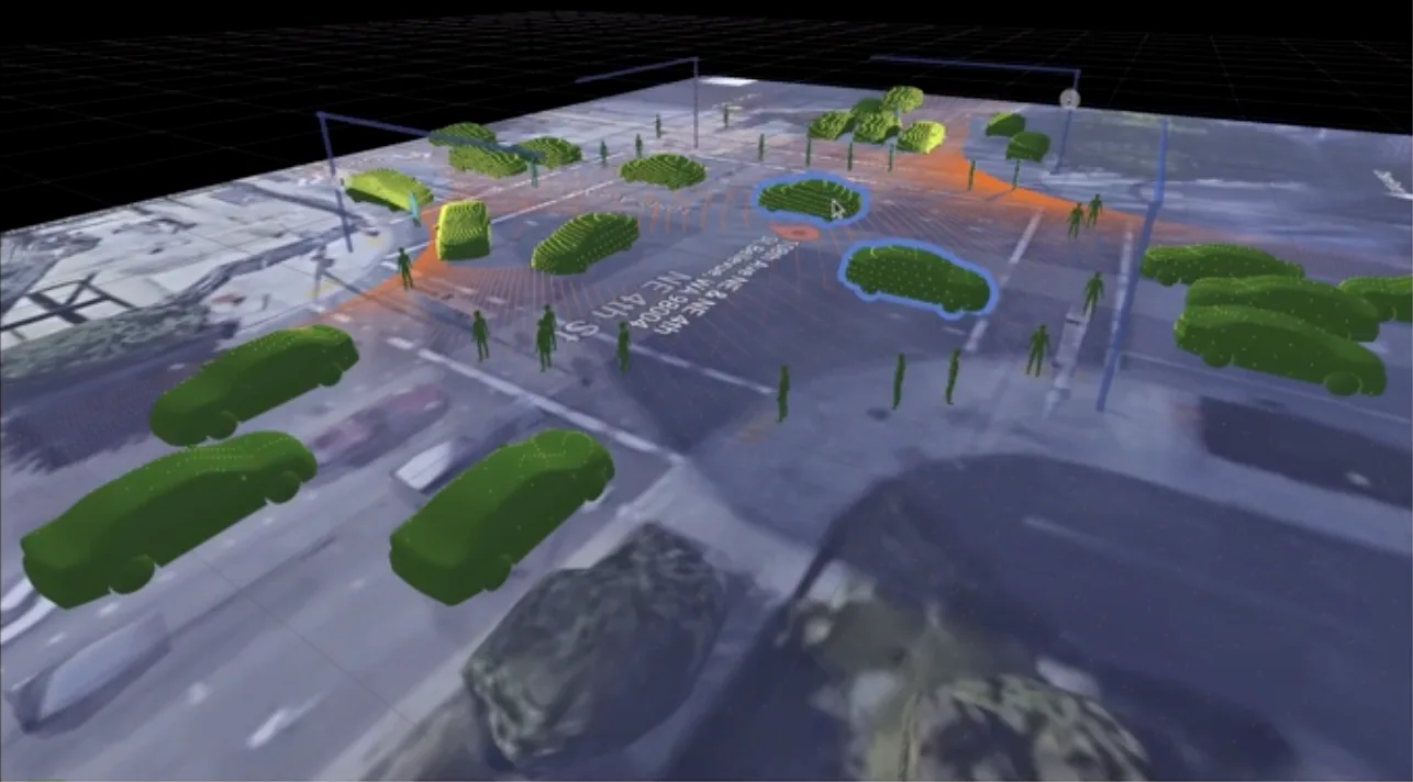
Simulation tool showcasing how lidar works during an intersection with pedestrians and cars

The installation is super easy.

Outsight’s software comes embedded into a ready to use Edge processing device that also takes care of powering the LiDAR. The data from multiple sensors can be combined in real-time.

Now you are ready to create Zones of interest using the provided Web User Interface. No development is required.
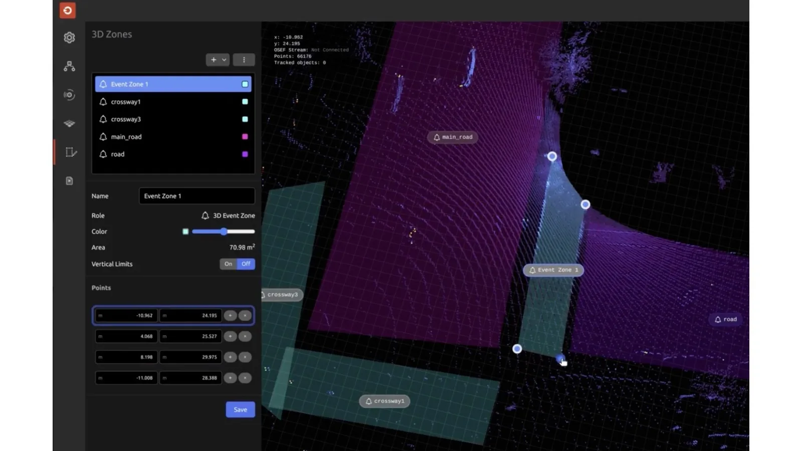
Outsight's lidar software creating zones of interests within an road intersection

These zones, combined with the Object Tracking feature, will trigger events as soon as an object is entering or leaving them.

That includes Pedestrians, for example entering crosswalks, and vehicles that should stop at traffic lights.
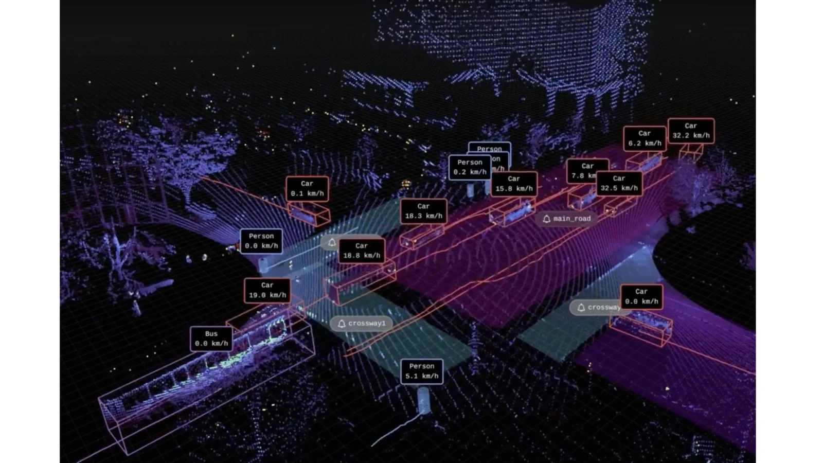
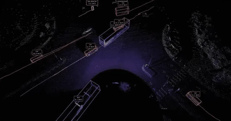
Lidar scan of an intersection with people tracking and vehicle tracking.

The data related to these events is delivered in real-time, allowing alarms to be triggered whenever necessary.

The same information, aggregated over time, feeds a Dashboard.

You can now not only react to short-term events, but also analyse trends and track Key Indicators over long periods of time.

And this is how simple and quick it is to create an End-to-End application for Smart Cities.

Outsight processing software, thanks to the unique value of 3D data collected by LiDAR, deliver an unprecedented level of Spatial Intelligence.

Learn more in this article:

LiDAR Software Expands ITS Solutions

With the global rise of 3D sensor demand, LiDAR has never been so accessible and it’s becoming essential for Intelligent Transportation System applications.

Read article →

Related Articles

APPLICATIONS

LiDAR Software - an enabler for expanding ITS solutions

With the global rise of 3D sensor demand, LiDAR has never been so accessible and it’s becoming essential for Intelligent Transportation System applications.

APPLICATIONS

From Inductive Loops to LiDAR Solutions: The Future of City Traffic Monitoring

With Inductive Loops' limitations becoming increasingly evident, LiDAR solutions are quickly becoming the next wave for city traffic monitoring

Let's connect

Send us a Message

Drop your email and we'll get back to you as soon as possible.

Frequently Asked Questions

  • How long does it take to simulate a LiDAR deployment for a smart city intersection?

    A browser-based 3D simulation integrated with mapping data can be completed in under an hour for a typical single-intersection layout. Within the Outsight SHIFT platform, this simulation step identifies optimal sensor positions, orientations, and the minimum number of sensors needed to achieve full coverage, including occlusion-free detection of pedestrians and cyclists. Running this step before purchasing hardware prevents over-ordering and avoids costly repositioning after physical installation. The City of Bellevue applied this kind of infrastructure-based LiDAR planning for its Vision Zero intersections, demonstrating how simulation-first workflows reduce both deployment time and long-term operational risk.

  • What edge hardware is needed to run LiDAR perception software at a roadside ITS site?

    Infrastructure-based LiDAR perception runs on compact edge processing devices mounted at or near the sensor. The device handles both power delivery to the LiDAR unit and real-time fusion of point clouds from multiple sensors simultaneously. No server room or cloud round-trip is required for the core perception and event-triggering pipeline, which keeps latency low and makes the installation viable at remote or power-constrained intersections. Outsight's SHIFT platform is designed around this architecture: its sub-50ms end-to-end pipeline executes entirely at the edge, supporting multi-vendor LiDAR hardware across manufacturers such as Hesai, RoboSense, and Ouster without requiring proprietary compute infrastructure.

  • What is a Vulnerable Road User in the context of LiDAR-based ITS?

    In ITS terminology, a Vulnerable Road User (VRU) is any non-motorized or low-protection road participant: pedestrians, cyclists, e-scooter riders, and wheelchair users. LiDAR classifies these entities by their 3D shape and motion profile rather than by image recognition, so classification holds in darkness, glare, and rain. Detecting VRU entry into a crosswalk or conflict zone is one of the primary event triggers that feeds both real-time alerts and long-term safety analytics in a smart intersection deployment. Outsight's SHIFT platform applies this classification approach at infrastructure scale, tracking VRUs anonymously through 3D LiDAR sensors mounted in the infrastructure itself, as demonstrated in deployments such as the City of Bellevue's Vision Zero intersections, where the goal is to reduce serious injuries and fatalities among the most exposed road users.

  • How does a near-miss event get detected and logged at a LiDAR-equipped intersection?

    A near-miss is detected when the 3D trajectories of two tracked entities converge within a defined spatial and temporal threshold inside a zone of interest, typically a crosswalk or a lane-crossing point. The system assigns each entity a persistent anonymous ID from the moment it enters the sensor field, so relative velocity and closing distance can be computed frame by frame. Outsight applies this logic through its SHIFT platform, which runs a sub-50ms end-to-end pipeline so the convergence calculation stays current with fast-moving traffic. When the threshold is crossed, an event record is written to the real-time stream and to the analytics store simultaneously, making it available both for immediate alerting and retrospective safety analysis, as demonstrated in deployments such as the City of Bellevue's Vision Zero intersection program.

  • Can the same LiDAR sensors used for real-time alerts also feed a long-term traffic KPI dashboard?

    Yes. The underlying data pipeline writes events to two destinations in parallel: a real-time stream for live alarms and a time-series store for aggregated analytics. This means the same physical infrastructure supports both operational responses (a signal controller receiving a pedestrian-in-crosswalk alert) and strategic planning (a city traffic engineer reviewing peak-hour near-miss frequency across six months). The Outsight SHIFT platform is architected around exactly this dual-path model, covering situational awareness and analytics within a single deployment, as demonstrated in smart-city intersections such as those in Bellevue's Vision Zero program. No second sensor layer or separate data collection pass is needed.

  • Does a LiDAR-based ITS deployment require custom software development to configure zones and alerts?

    Zone definition and alert configuration are handled through a web-based user interface without custom code. An operator draws zones of interest over the live 3D view of the intersection, assigns entry and exit triggers to each zone, and maps those triggers to alert outputs or data fields in the analytics dashboard. The Outsight SHIFT platform follows this no-code approach, allowing zone geometry and alert logic to be configured directly over a real-time 3D scene rather than through scripted integrations. This matters for city deployments because traffic engineering teams, not software developers, are typically the operators responsible for maintaining the system after installation, as seen in smart-city programs such as the City of Bellevue's Vision Zero intersections.