Skip to content
Insights
From Inductive Loops to LiDAR Solutions: The Future of City Traffic Monitoring

From Inductive Loops to LiDAR Solutions: The Future of City Traffic Monitoring

With Inductive Loops' limitations becoming increasingly evident, LiDAR solutions are quickly becoming the next wave for city traffic monitoring


Traffic sensors are essential tools for cities all around the world. Among these sensors, inductive loops have been widely used to detect vehicles and their timing at intersections.

However, these loops have several drawbacks, such as being unable to differentiate between different types of vehicles or pedestrians and failing to provide detailed traffic information.

Besides, inductive loops installation and maintenance costs are high, and their lifespan is quite limited (only 3-7 years).

Because of that, cities are searching for new ways to collect traffic data, such as radar, CCTV cameras, and LiDAR sensors.

LiDAR solutions, in particular, offer an effective and economical solution for traffic monitoring by leveraging advanced sensors and software to gather multimodal, real-time traffic data.

Outsight, pioneer and leader in LiDAR software applications, is a global company that provides LiDAR-based solutions for city planners and engineering companies to deeply perceive and improve mobility in smart cities.

Outsight's lidar software for ITS, tracking vehicles and car type categories

Outsight’s software can generate and record an output data containing the detected objects, their positions, and classification in real-time in an accessible format

In this article, we’ll explore how LiDAR solutions, such as those provided by Outsight, are replacing inductive loops in city traffic monitoring and revolutionizing the way cities collect and analyze traffic data.

The Problems with Inductive Loops for Traffic Management

Inductive loops are a technology developed to detect metal in automobiles such as trucks and other vehicles. However, they are unable to identify other objects on the road, including pedestrians and cyclists.

Even though inductive loops produce accurate results under ideal conditions, factors like pavement degradation, improper installation, and street maintenance can impair a loop’s integrity and reduce its performance.

Moreover, traffic density, vehicle activity, and traffic structure are additional factors that may reduce the accuracy of inductive loops.

In terms of installation and maintenance, inductive loops are obtrusive, time-consuming, and costly.

Why waste money on other technologies that cost too much and takes too long to install, when lidar is cheaper due to the number of lidars needed for the coverage and easy to install

The installation of inductive loops requires digging up roads, resulting in road closures.

Despite being accurate, inductive loops are unable to detect the turning direction of a vehicle or sense dangerous intersections.

Different KPIs that Outsight's Spatial AI software for ITS based challenges

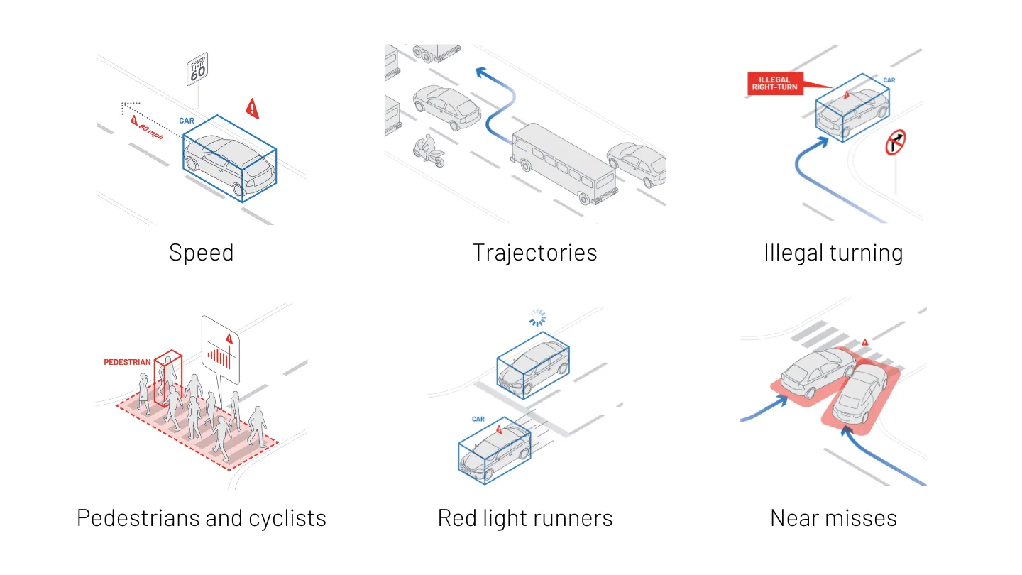
When a vehicle crosses the detection zone, inductive loops identify it, but they are unable to detect the speed or trajectory of the vehicle, hindering the quantity and quality of valuable data for traffic and city planners

In a summary, while inductive loops can offer information on how many vehicles have passed through the detection area, they have limitations that make them unsuitable for identifying pedestrians and cyclists, detecting the turning directions of vehicles, and sensing dangerous intersections.

The next article shows how Outsight’s traffic monitoring applications work to cover all these aspects:

Outsight’s Comprehensive ITS Solution

Outsight provides the easiest and most comprehensive way to use LiDAR in ITS: from Simulation to Deployment and Analytics’ Dashboard.

Read article →

LiDAR Solutions: the Best Alternative to Inductive Loops

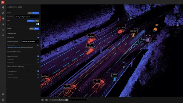
The combination of LiDAR and Perception software is a perfect fit for effective traffic management. LiDAR collects 3D points to form a point cloud, and the software, like the one from Outsight, does unlimited data processing to generate actionable KPIs and alerts in a user-friendly dashboard and a stream of data that can be accessed through an API for integrators and solution providers.

How Outsight takes RAW 3D lidar data and transforms it into real-time spatial intelligent solutions and actionable API

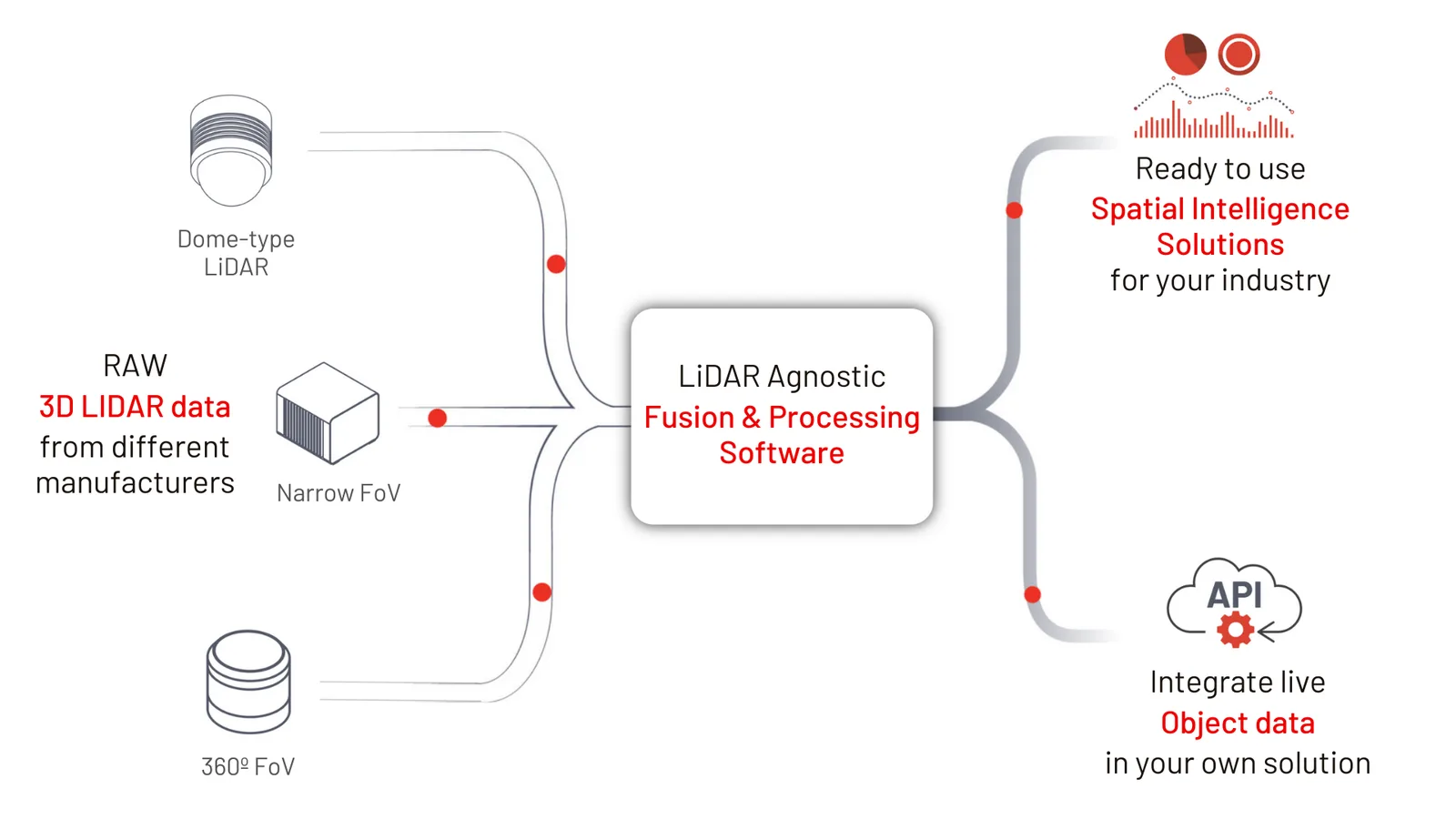
Outsight’s software output can be both integrated through an API to provide information to any system or displayed in the form of a Spatial Intelligence dashboard

LiDAR pulse rates usually vary from 10,000 to more than 2 million pulses per second, and a single laser pulse can generate multiple returns.

Software algorithms then process the output of LiDAR pulse returns to make sense of a specific environment, such as road traffic structure, in real-time and in any lightening conditions.

Earlier, teams manually labeled LiDAR data to identify key objects in the scan. Obviously, the effort was both time-consuming and laborious, requiring highly specialized knowledge and expertise.

Outsight’s software can now help automate the classification process thanks to advancements in LiDAR sensors and 3D image processing. It can also record and monitor all information about an object trajectory, its dimensions and speed.

Outsight LiDAR software classifies objects, such as road asset landmarks, with extremely high precision

Conclusion

Today, LiDAR solutions not only help us sort through the complexity of sensors to identify nearby vehicles or infrastructure for further analysis but also provide critical indicators for traffic operators to understand dangerous intersections, detect when a vulnerable road user (VRU) wants to cross the street, or identify vehicles in the wrong direction.

Outsight software detect, track and classifies different types of vehicles, people and VRUs

Thanks to its accuracy, privacy compliance, and processing capacity in real-time, LiDAR-based software solutions are now being used in many different industries.

These industries include Intelligent Transportation Systems (ITS), People Flow monitoring, Industrial and Volume Measurement. Learn about each one of them in this article:

Top 5 LiDAR Solution Applications

From smart cars and robots to logistics, construction, and agriculture, multiple businesses are impacted today by LiDAR’s flexible and highly precise solutions

Read article →

With the availability of advanced and cost-efficient solutions like Outsight, city planners now have access to a unique opportunity to collect and 24/7 monitor real-time, multimodal traffic data with ease, enabling informed decisions to improve safety.

Thanks to an effective and quick installation, LiDAR-based solutions can transform the way cities collect traffic data and pave the way for safer, more efficient transportation systems.


Related Articles

AIRPORTS

Aeroporti di Roma to deploy Outsight's Physical AI solution at scale across Rome Fiumicino Airport

Aeroporti di Roma (ADR) is expanding its collaboration with Outsight to a large-scale deployment across almost all Schengen common-use areas at Rome Fiumicino Airport.

CORPORATE

Intel and Outsight Announce Strategic Collaboration to Bring Physical AI–Powered Spatial Intelligence to the Enterprise Edge

Outsight’s Shift platform integrated into Google Distributed Cloud Edge powered by Intel Xeon 6 SoC – Live demonstration at Google Cloud Next 2026

Let's connect

Send us a Message

Drop your email and we'll get back to you as soon as possible.

Frequently Asked Questions

  • How long do inductive loop sensors typically last before needing replacement?

    Inductive loop detectors have a functional lifespan of roughly 3 to 7 years under normal road conditions. That figure shrinks further when pavement degrades, when installation is imprecise, or when street resurfacing crews cut through the loop wiring. The replacement cycle requires reopening the road surface each time, compounding both direct costs and traffic disruption. Overhead LiDAR sensors mounted on poles or gantries avoid pavement contact entirely, removing the road-repair dependency that drives so much of the total cost of ownership for loop-based deployments. Outsight applies this infrastructure-based approach in smart-city programs such as the City of Bellevue's Vision Zero intersections, where LiDAR sensors mounted in the infrastructure feed the SHIFT platform with real-time 3D traffic data without any embedded road hardware to maintain or replace.

  • What vehicle behaviors can LiDAR detect that inductive loops physically cannot?

    An inductive loop registers the presence of a metal vehicle crossing a fixed detection zone, nothing more. It cannot capture speed, trajectory, turning direction, or vehicle dimensions. LiDAR, processing 3D point clouds at high pulse rates, tracks each vehicle's full path through a scene: approach angle, lane-change events, turning radius, and deceleration profile. That trajectory data is what traffic engineers need to identify conflict points at intersections and to flag wrong-way driving, use cases that a loop-only deployment cannot support at all. Outsight applies this capability at the infrastructure level through its SHIFT platform, with deployments such as the City of Bellevue's Vision Zero intersections using anonymous 3D LiDAR to capture precisely these vehicle behaviors in real time.

  • Why is classifying vulnerable road users like cyclists a problem for legacy traffic sensors?

    Inductive loops detect inductance changes caused by metal mass. Bicycles and pedestrians generate little or no detectable signal, so the sensor either misses them entirely or misclassifies them as noise. Radar shares a similar limitation at low return intensity. LiDAR captures 3D shape and motion regardless of material composition, so a cyclist, a wheelchair user, and a pedestrian each produce a distinct bounding-box signature that software can classify independently. This classification gap is one of the primary reasons Vision Zero programs have turned to LiDAR as the sensing layer for intersection safety analysis. The City of Bellevue, for example, uses Outsight's infrastructure-based LiDAR perception at intersections specifically to detect and classify vulnerable road users in real time, supporting its Vision Zero safety objectives.

  • Does installing overhead LiDAR at an intersection require closing the road?

    Overhead LiDAR sensors mount on existing poles, gantries, or signal mast arms without cutting into the road surface. Installation typically requires a bucket truck and a few hours of work per sensor, with no lane closures beyond a temporary maintenance window. Inductive loops, by contrast, require sawcutting slots into the asphalt, inserting wire coils, and re-sealing the pavement, a multi-day process that closes lanes or full intersections. This infrastructure-based deployment model is central to how Outsight applies LiDAR at city scale: the SHIFT platform ingests data from sensors mounted on existing street furniture, avoiding the civil works entirely. The City of Bellevue's Vision Zero intersections follow this approach. The installation time difference remains a significant operational factor for city traffic departments managing congested networks.

  • Can a LiDAR traffic sensor feed data directly into a traffic management center's existing software?

    LiDAR perception software outputs structured data streams, including classified entity tracks, speed vectors, occupancy counts, and event alerts, through documented APIs. Most modern traffic management center platforms can ingest these feeds via standard protocols such as REST or MQTT, or through integration middleware. The output can also populate UTMC (Urban Traffic Management and Control) databases or feed variable message signs directly. The key requirement is that the LiDAR software layer handles the conversion from raw point-cloud data to structured objects before it reaches the TMC, which is the role of edge preprocessing running at or near the sensor. Outsight's SHIFT platform addresses this through a sub-50ms end-to-end pipeline that delivers anonymized, structured object tracks to downstream systems via open integrations, as demonstrated in smart-city deployments such as the City of Bellevue's Vision Zero intersections.

  • How does LiDAR pulse rate affect the quality of traffic data at a busy urban intersection?

    Pulse rate determines how many 3D measurement samples a sensor collects per second. LiDAR sensors used in traffic applications typically emit between 10,000 and more than 2 million pulses per second, with higher rates producing denser point clouds. At a busy intersection with multiple overlapping vehicles, a denser cloud lets the perception software separate adjacent objects, a truck beside a cyclist or two cars side by side, more reliably than a sparse cloud. Effective object separation at close range depends on both pulse rate and the angular resolution of the specific sensor model, which is why multi-vendor compatibility in the processing software matters for mixed deployments. Outsight's SHIFT platform addresses this directly by supporting hardware from multiple LiDAR manufacturers, including Hesai, RoboSense, Ouster, and Velodyne, so operators are not locked into a single sensor's pulse-rate characteristics when building out city traffic infrastructure.