
Skip to content
Insights
Large public events where LiDAR technology offers an alternative to facial recognition.

Is LiDAR technology an alternative to facial recognition?

Video facial recognition seemed to be the only way to address security issues during large events, until LiDAR joined the party.


On March 23, 2023 the French National Assembly passed the Olympic bill, authorizing the use of algorithms to process images recorded by cameras or drones.

Even before it was voted, civil rights advocates expressed serious concerns about the protection of privacy when using videos, as well as the processes that AI could use to identify and highlight supposedly “suspicious” behavior. Those concerns are definitely legitimate as we may be facing risks of abuse.

With the right software, LiDAR technology offers superior performance compared to traditional monitoring solutions such as cameras, while guaranteeing the protection of privacy.

To discover the advantages of LiDAR solutions read this article :

LiDAR vs Camera: Superior People Flow Monitoring Solutions

LiDAR solutions’ accuracy and versatility make them a superior solution and will undoubtedly lead to improved safety and efficiency in high-traffic areas.

Read article →
A technology that goes beyond autonomous vehicles

Originally designed for the autonomous vehicle market, the applications of LiDAR technology are now diversifying.

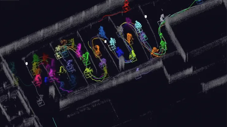
LiDAR technology can map any environment with unparalleled accuracy and, thanks to adapted software solutions, react to any change such as the presence of a person or a moving object in a designated area.

And unlike traditional imaging technologies like cameras or radar, its effectiveness is not impacted by weather or lighting conditions.

If you also take into consideration its ability to analyze multiple elements simultaneously in real time, LiDAR technology is particularly relevant to address flow analysis and security issues within Smart Cities and Smart Infrastructures (such as Airports, Train Stations, Stadiums…)

All of these features can be combined within proper LiDAR based software solutions’, unlocking LiDAR’s full ability to provide real-time information in populated areas and sensitive sites.

LiDAR Enhances Security Solutions

LiDAR-based security systems, with the right perception software, provide smart, efficient, and automated means of preventing threats and avoiding false positive detections.

Read article →

Respecting privacy and guaranteeing security

Since people and objects are only perceived as “point clouds” in the sensor’s point of view, LiDAR technology does not require face identification tools or image processing software to monitor a specific location.

This commitment to privacy protection is also reflected in the data transmission.

Thanks to 3D LiDAR based software like Outsight’s, a LiDAR installation is capable of processing up to 12 terabytes of data per hour in real time at the sensor location.

Using a real-time Edge computing solution for data collection and processing not only increases security, but also naturally reduces the need for external data transmission. In addition, the processed data consumes only 1% of the original bandwidth, minimizing the strain on local and wide area network transmission.

Overview of Outsight

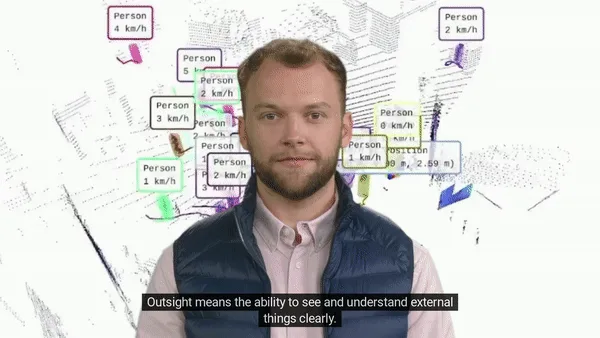
Outsight means the ability to see and understand things clearly: we transform Raw 3D data from different manufacturers into actionable information.

Read article →
Preparing the infrastructures of tomorrow

Major events such as the Olympic Games are an ideal opportunity to modernize cities and infrastructures’ monitoring systems to optimize safety and operation efficiency, on different levels.

Apart from large-scale renovation projects, upgrading infrastructure remains expensive. The 2024 Olympics are therefore a perfect example of opportunity to integrate advanced technologies throughout Smart Cities, beyond traditional surveillance devices such as cameras.

As an example, take a look at how airports are already deploying them:

LiDAR Manages Increased Airport Traffic

See how and why Airports are increasingly using LiDAR-based software solutions to tackle their biggest challenges, leveraging the unique value of Spatial Intelligence.

Read article →

By adopting this type of technology, Smart Cities Operators are not only demonstrating the comprehension of their operational needs, but also position themselves as key players in supporting advanced solutions designed to increase user’s safety while guaranteeing the respect of their privacy.

Thanks to 3D LiDAR-based software, Smart Cities Operators can now access accurate and anonymous real time spatial intelligence data relevant to their specific needs.

We believe that accelerating the adoption of LiDAR technology through simple and scalable software solutions will significantly contribute to a smarter, safer and more sustainable urban environment.
Related Articles

SECURITY

Making Spaces Truly Smart with LiDAR based People Counting

Enhance efficiency, optimize costs, and ensure security in smart spaces, from retail outlets and offices to large venues and public areas.

APPLICATIONS

LiDAR in Public Spaces: Top 6 Key Advantages for Improved Operations and Maintenance

Discover the benefits of LiDAR technology in public spaces: people counting, anonymity, public safety, easy installation, and error-free data.

Let's connect

Send us a Message

Drop your email and we'll get back to you as soon as possible.

Frequently Asked Questions

  • What are the privacy risks of using AI video analytics at large public events?

    Camera-based AI analytics at mass events raise two distinct risks. First, behavioral flagging: algorithms trained to detect "suspicious" patterns can produce racially or demographically skewed outputs, as civil-rights researchers have documented repeatedly. Second, function creep: footage collected for crowd safety can be repurposed for identity investigations without the subjects' knowledge. LiDAR-based spatial tracking sidesteps both because it captures geometry and motion, not pixels, so no face or identity is ever encoded in the data stream, removing the technical precondition for either risk. Outsight's infrastructure-based approach, deployed at venues such as Paris-Charles de Gaulle airport and SNCF train stations in France, operates on this principle: the Motional Digital Twin records how people move through a space, never who they are, making re-identification technically impossible rather than merely policy-restricted.

  • Can LiDAR detect suspicious behavior without recording who a person is?

    Yes. Behavioral classification in a LiDAR-based system works on motion signatures: speed, trajectory, dwell time, proximity to restricted zones, and directional changes. A person who enters a restricted area, moves against a crowd flow, or remains stationary in a sensitive zone triggers an alert based purely on those spatial attributes. This is how Outsight's infrastructure-based approach operates: the SHIFT platform captures shape and motion in 3D, never faces, license plates, or biometric data, so no identity record is created at any point in the pipeline. The system answers the operational question (something anomalous is happening at coordinates X, Y) without associating the alert with any individual. Privacy compliance and real-time situational awareness coexist by design, not by policy.

  • How much bandwidth does a LiDAR security deployment consume compared to raw sensor output?

    Raw 3D LiDAR point clouds are data-intensive: a single sensor can generate hundreds of megabytes per second. Edge preprocessing compresses that output dramatically. After on-site processing, the structured data stream (tracked entities, classification labels, event alerts) consumes roughly 1% of the original raw bandwidth. Outsight's SHIFT platform follows this architecture, running a sub-50ms end-to-end pipeline that processes point clouds at the edge and transmits only the refined object data downstream. That compression ratio makes LiDAR viable for sites with constrained network infrastructure, such as airports or train stations, and reduces exposure to interception during transmission.

  • How does facial recognition accuracy degrade in crowded outdoor environments and does LiDAR have the same problem?

    Facial recognition performance drops sharply in outdoor crowds for three compounding reasons: variable lighting degrades image quality, faces in dense crowds are partially occluded by other people, and subjects rarely face cameras directly. LiDAR does not share those constraints. It is an active sensor that generates its own signal, so ambient light is irrelevant. It tracks the bounding volume of a person rather than their face, so partial occlusion handled by fusing overlapping sensor fields does not cause identity loss, only a momentary gap in one sensor's view. Outsight's infrastructure-based approach extends this further: by deploying LiDAR sensors across a fixed environment rather than on moving entities, the SHIFT platform builds overlapping fields of view that collectively maintain continuous tracking even as individuals move through dense crowds, without capturing any facial or biometric data at any point in the pipeline.

  • The EU AI Act, finalized in 2024, classifies real-time remote biometric identification in public spaces as a high-risk AI application and restricts its use to a narrow set of law-enforcement exceptions. GDPR separately requires a lawful basis for processing biometric data, which facial recognition always produces. LiDAR-based spatial tracking does not process biometric data by design, placing it outside the biometric-identification regulatory tier entirely and simplifying compliance for event organizers and city operators. Outsight's Motional Digital Twin operates on this principle: LiDAR captures shape and motion rather than faces or biometric identifiers, making anonymity a technical property of the sensor itself rather than a policy choice applied after collection.

  • Can the same LiDAR sensors used for crowd safety at an event be repurposed for city operations afterward?

    Infrastructure-mounted LiDAR sensors are general-purpose spatial sensors. After an event, the same hardware can support pedestrian and vehicle flow measurement at intersections, transit hub occupancy monitoring, parking management, or perimeter security at adjacent facilities. Because the intelligence sits in software rather than in a sensor-specific appliance, operators reconfigure the analytics layer for a new use case without replacing hardware. Outsight's SHIFT platform is built around exactly this model: the same infrastructure-based sensor network that tracks crowd movement during an event can be redirected to smart-city operations, as demonstrated in deployments like the City of Bellevue's Vision Zero intersection program. This reuse model is part of why major events are frequently cited as the catalyst for broader smart-city LiDAR investment.

  • What did the French Olympic bill passed on March 23, 2023 authorize for video surveillance?

    On March 23, 2023, the French National Assembly passed the Olympic bill, which authorized the use of algorithms to process images recorded by cameras or drones. Even before the vote, civil rights advocates raised serious concerns about the protection of privacy when using video. They also questioned the processes AI could use to identify and highlight supposedly suspicious behavior. Those concerns are described as legitimate, since there may be risks of abuse.

  • Why did civil rights groups object to AI video analytics for the Paris 2024 Olympics?

    Civil rights advocates objected because algorithmic processing of camera and drone images, authorized by the Olympic bill passed in March 2023, raises serious concerns about the protection of privacy. They also worried about the processes AI could use to identify and highlight supposedly suspicious behavior. These concerns are considered legitimate, since there may be risks of abuse. With the right software, LiDAR technology offers superior performance compared to cameras while guaranteeing the protection of privacy.

  • How much raw data can a LiDAR installation process per hour at the sensor location?

    With 3D LiDAR-based software like Outsight's, a LiDAR installation can process up to 12 terabytes of data per hour in real time, directly at the sensor location. This real-time Edge computing approach to data collection and processing increases security, because far less data needs to leave the site. The processed output uses only about 1% of the original bandwidth. That reduces the load on local and wide area networks at large event venues and smart infrastructure.

  • Why does processing LiDAR data at the edge strengthen privacy at large public events?

    Processing LiDAR data at the edge means the raw 3D data is analyzed in real time at the sensor location, which naturally reduces the need for external data transmission and increases security. The processed data consumes only 1% of the original bandwidth, minimizing the strain on local and wide area networks. LiDAR also perceives people only as point clouds, so no face identification or image processing is needed to monitor an area. This commitment to privacy protection is therefore reflected both in how people are perceived and in how data is transmitted.

  • Does LiDAR crowd monitoring at outdoor events keep working at night and in bad weather?

    Yes. LiDAR keeps its effectiveness in all weather and lighting conditions, an advantage over traditional imaging technologies such as cameras or radar. The technology can map any environment with unparalleled accuracy and analyze multiple elements simultaneously in real time. With adapted software, it reacts to any change, such as the presence of a person or a moving object in a designated area. Because people are perceived only as point clouds, this monitoring works without face identification tools.

  • Which smart infrastructures benefit most from LiDAR for anonymous flow analysis and security?

    LiDAR technology is particularly relevant for flow analysis and security in Smart Cities and Smart Infrastructures such as airports, train stations and stadiums. These are populated areas and sensitive sites where operators need real-time information about many people at once. LiDAR works in any weather or lighting and analyzes multiple elements simultaneously. Because people appear only as point clouds, operators get accurate, anonymous spatial intelligence without facial recognition.

  • Why are major events like the Olympic Games a good moment to upgrade city monitoring systems?

    Upgrading infrastructure is expensive outside large-scale renovation projects, so major events such as the Olympic Games create an ideal opportunity to modernize monitoring systems in cities and infrastructure. The 2024 Olympics were a clear example of a chance to integrate advanced technologies beyond traditional surveillance devices such as cameras. Airports were already deploying LiDAR-based software to handle rising traffic. Smart City operators adopting it can improve safety and operational efficiency while respecting privacy.

  • Can LiDAR track many people and objects at the same time in a crowded event space?

    Yes. LiDAR can analyze multiple elements simultaneously in real time, which is one reason it suits crowded Smart City environments and venues such as stadiums and train stations. The sensor maps its surroundings with high accuracy and, with adapted software, reacts to any change such as a person or moving object entering a designated area. It keeps working in any weather or lighting condition. People appear only as point clouds, so monitoring stays anonymous.

  • How does LiDAR software detect a person entering a restricted zone at an event venue?

    LiDAR first maps the environment with high accuracy, creating a precise 3D picture of the site. Adapted software then watches for any change in that picture, such as the presence of a person or a moving object in a designated area, and reacts in real time. People are perceived only as point clouds, so detection works without face identification or image processing. This approach performs in any weather or lighting and can follow many people at once.

  • What do smart city operators gain from anonymous real-time spatial intelligence data?

    With 3D LiDAR-based software, Smart City operators can access accurate and anonymous real-time spatial intelligence data tailored to their specific needs. This supports safety and operational efficiency in populated areas and sensitive sites. Operators who adopt it show that they understand their operational needs while respecting users' privacy. Outsight believes that simple, scalable LiDAR software will contribute to a smarter, safer and more sustainable urban environment.

  • Can I track people's movements without collecting personal data?

    Yes, by using sensors that capture geometry only. 3D LiDAR measures distances with laser light and represents each person as a cluster of 3D points with a position, height and trajectory, with no face, clothing detail or image. Physical AI software then follows each individual through the space with an anonymous ID and derives flows, dwell and wait times. Outsight's Spatial Intelligence Platform works this way, so organisations get individual-level movement insight at scale with no personal data captured.