Skip to content
Insights
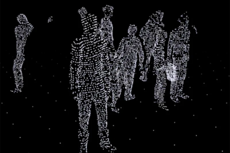
LiDAR point cloud of people in a public space, highlighting an alternative to traditional camera-based surveillance.

Laser detection challenges camera based analytics for surveillance and people tracking applications

As reported by Ron Alalouff, the use of LiDAR to detect and track people and objects has the potential to be the next big thing in situational awareness.


Source: IFSEC Global.

LiDAR technology has revolutionized the way we detect and measure the position, size, shape, and dimensions of objects. It is not only limited to making high-resolution maps and 3D models or controlling autonomous vehicles, but it can also be used for people tracking and analytics.

Outsight, a company that specializes in decoding raw data from LiDAR sensors, offers a software that provides actionable information for security and monitoring applications. One of their reference sites is Paris Charles de Gaulle airport, where their 3D smart monitoring system utilizes LiDAR sensors to track crowd and people flows, optimizing passenger journeys through the airport.

While cameras have their place, LiDAR sensors combine data from multiple sensors and track thousands of people in real-time.

“It’s not easy to track thousands of people in real time using just cameras, though that’s what we are doing with the LIDAR sensors at Charles de Gaulle,” says Outsight’s CEO, Raul Bravo. “The sensors are capturing data about where things are, which makes it much easier to combine data from multiple sensors. But there are many things you can’t do with LIDAR, so cameras have their place.”

Read more by checking the original article.

Laser detection challenges camera based analytics for surveillance and people tracking applications - IFSEC Global | Security and Fire News and Resources

Using light detection and ranging to detect and track people and objects could be the next big thing in situational awareness.

Learn more →


Related Articles

SECURITY

Stay One Step Ahead with LiDAR Based Security Solutions

LiDAR technology is transforming the security industry by offering high-accuracy, all-weather monitoring, reducing false alarms, and enhancing perimeter & access control.

SECURITY

LiDAR solutions for security

LiDAR-based security systems, with the right perception software, provide smart, efficient, and automated means of preventing threats and avoiding false positive detections.

Let's connect

Send us a Message

Drop your email and we'll get back to you as soon as possible.

Frequently Asked Questions

  • Can LiDAR track thousands of people simultaneously in a busy airport terminal?

    Yes. Infrastructure-mounted LiDAR sensors fuse their outputs into a single shared 3D point cloud, so every person in a monitored area receives a unique anonymous ID that persists across the entire sensor network. Dallas Fort Worth Airport, the world's largest 3D LiDAR airport deployment, demonstrates this at scale through Outsight's SHIFT platform, which maintains real-time tracking across a site-wide network with a sub-50ms end-to-end pipeline. The spatial backbone works by measuring position and shape rather than interpreting pixel data, which makes it computationally feasible to maintain thousands of tracked entities in parallel. Camera-based analytics face compounding accuracy challenges as crowd density increases because occlusion compounds rapidly in 2D imagery, a problem that LiDAR-based depth sensing avoids by construction.

  • What can cameras do in a security setup that LiDAR cannot?

    Cameras capture color, texture, and fine visual detail that LiDAR physically cannot record. This makes cameras valuable for post-incident investigation workflows requiring visual identification, reading signage or markings, or verifying the appearance of a suspect or object. LiDAR returns geometry and motion but no image data. The two technologies are typically deployed together: LiDAR handles real-time detection, tracking, and alerting, while cameras cover the visual-evidence and verification layer. Outsight's SHIFT platform follows exactly this division of responsibility, using infrastructure-based LiDAR to deliver anonymous, real-time situational awareness across sites such as airports and datacenters, while leaving optical verification to camera systems already in place through open integrations.

  • How does LiDAR-based people tracking handle privacy regulations compared to camera systems?

    LiDAR sensors emit laser pulses and measure surface geometry, recording position, shape, and motion. They are physically incapable of capturing faces, license plates, or any biometric data, which means there is no personal information to anonymize after the fact because none is recorded in the first place. Outsight describes this property as "anonymous by definition," and it underpins how the SHIFT platform processes people and vehicle flows across airports, train stations, and smart-city intersections without triggering the consent and retention obligations that apply to camera footage. Camera systems, by contrast, capture images that may contain identifiable data, requiring post-processing anonymization steps to achieve comparable compliance with GDPR and related regulations.

  • How does multi-sensor LiDAR fusion improve situational awareness over a single sensor?

    A single LiDAR sensor has a fixed field of view and physical blind zones behind obstacles or around corners. When multiple sensors are fused into one shared 3D point cloud, a person hidden from one sensor remains visible to another. Outsight refers to this capability as shadowless perception, achieved through the infrastructure-based deployment model underpinning its Motional Digital Twin. Fusing sensors at the infrastructure level eliminates coverage gaps that would otherwise require redundant sensors at every angle, and it allows a single tracked entity ID to follow a person continuously as they move between sensor zones across a large site. In large-scale deployments such as Dallas Fort Worth Airport, this multi-sensor fusion approach enables consistent, real-time situational awareness across expansive, complex environments without relying on any single sensor's limited perspective.

  • Is LiDAR people tracking only practical for large sites like airports or does it scale down?

    The underlying perception pipeline scales independently of site size. The same software that runs across an entire airport terminal can be scoped to a single building entrance, a corridor checkpoint, or a restricted zone around a server rack. Outsight's SHIFT platform, for example, is deployed at large-scale sites such as Dallas Fort Worth and Paris-Charles de Gaulle, but the same platform also covers security-sensitive facilities like datacenters where the tracked area may span only a few rooms. The hardware footprint shrinks accordingly: a small deployment may need only one or two sensors. The economics favor LiDAR at sites where people density is high enough that camera-based tracking would require many overlapping cameras to achieve comparable per-person accuracy.

  • What is situational awareness in a physical security context and how does LiDAR support it?

    In physical security, situational awareness means knowing at any given moment where people and objects are, how they are moving, and whether any behavior crosses a defined threshold such as loitering, unauthorized zone entry, or unusual congregation. LiDAR contributes a continuous, real-time 3D picture of that movement, updated at sub-50ms latency, without requiring the lighting conditions that cameras depend on. Outsight's SHIFT platform applies this principle through infrastructure-mounted LiDAR sensors that build a live Motional Digital Twin of a site, enabling operators to define behavioral rules and receive instant alerts the moment a tracked entity's trajectory or dwell time crosses a threshold, rather than requiring manual video review. Because LiDAR captures shape and motion rather than faces or biometric data, this level of awareness is achieved anonymously by definition.

  • What did IFSEC Global report in 2023 about LiDAR challenging camera analytics for people tracking?

    In 2023, IFSEC Global published an article by Ron Alalouff on how LiDAR is challenging camera-based analytics for surveillance and people tracking. The piece argues that using LiDAR to detect and track people and objects could be the next big thing in situational awareness. It features Outsight, a company that specializes in decoding raw LiDAR data into actionable information for security and monitoring applications. Paris Charles de Gaulle airport is cited as one of Outsight's reference sites.

  • How is the 3D smart monitoring system used at Paris Charles de Gaulle airport?

    At Paris Charles de Gaulle airport, Outsight's 3D smart monitoring system uses LiDAR sensors to track crowd and people flows. Its purpose is to optimize passenger journeys through the airport. According to Raul Bravo, President Founder of Outsight, the LiDAR sensors at Charles de Gaulle track thousands of people in real time, something that is not easy to do using just cameras. IFSEC Global cited Charles de Gaulle as one of Outsight's reference sites in its 2023 report on LiDAR people tracking.

  • Why does LiDAR position data make combining multiple sensors easier in people tracking?

    Raul Bravo, President Founder of Outsight, explained to IFSEC Global that LiDAR sensors capture data about where things are. According to him, this makes it much easier to combine data from multiple sensors. The article notes that LiDAR sensors can combine data from multiple sensors and track thousands of people in real time. Outsight does this at Paris Charles de Gaulle airport, where its 3D smart monitoring system tracks crowd and people flows to optimize passenger journeys.

  • What does LiDAR software do with raw sensor data for security and monitoring applications?

    Outsight specializes in decoding raw data from LiDAR sensors. Its software provides actionable information for security and monitoring applications, as reported by IFSEC Global in 2023. At Paris Charles de Gaulle airport, one of Outsight's reference sites, this software powers a 3D smart monitoring system that uses LiDAR sensors to track crowd and people flows. The goal there is to optimize passenger journeys through the airport, with thousands of people tracked in real time.

  • What does LiDAR measure about objects, and why does IFSEC Global see it as relevant to people tracking?

    LiDAR technology detects and measures the position, size, shape and dimensions of objects. IFSEC Global notes that its use goes beyond making high-resolution maps and 3D models or controlling autonomous vehicles, since it can also be used for people tracking and analytics. The report suggests that using LiDAR to detect and track people and objects could be the next big thing in situational awareness. Outsight's software decodes raw LiDAR data into actionable information for security and monitoring applications.

  • Is LiDAR only used for mapping and autonomous vehicles, or also for people analytics?

    LiDAR is widely known for making high-resolution maps and 3D models and for controlling autonomous vehicles. It can also be used for people tracking and analytics, which is the focus of IFSEC Global's 2023 report by Ron Alalouff. Outsight's software, for example, tracks crowd and people flows at Paris Charles de Gaulle airport to optimize passenger journeys. IFSEC Global described using LiDAR to detect and track people and objects as potentially the next big thing in situational awareness.

  • Why is tracking thousands of people in real time difficult with cameras alone?

    Raul Bravo, President Founder of Outsight, told IFSEC Global that it is not easy to track thousands of people in real time using just cameras. He explained that this is what Outsight does with LiDAR sensors at Paris Charles de Gaulle airport. LiDAR sensors capture data about where things are, which makes it much easier to combine data from multiple sensors. Bravo also noted that there are many things LiDAR cannot do, so cameras still have their place.

  • How does LiDAR crowd tracking help optimize the passenger journey at Paris Charles de Gaulle?

    At Paris Charles de Gaulle, Outsight's 3D smart monitoring system uses LiDAR sensors to track crowd and people flows. According to Raul Bravo, President Founder of Outsight, the sensors at Charles de Gaulle track thousands of people in real time. This information is used to optimize passenger journeys through the airport. IFSEC Global cited Charles de Gaulle as one of Outsight's reference sites in its 2023 report on LiDAR for surveillance and people tracking.

  • Should a security team use LiDAR, cameras or both for surveillance and people tracking?

    According to Raul Bravo, President Founder of Outsight, cameras have their place and there are many things LiDAR cannot do. LiDAR excels at tracking large numbers of people in real time and at combining data from multiple sensors. Cameras keep their place in the security setup alongside LiDAR. For many security teams, the practical answer is to use both technologies together, each for the tasks it handles best. Outsight's position, as reported by IFSEC Global, is that LiDAR and cameras each have a role in situational awareness.

  • Which security and monitoring applications does LiDAR people-tracking software target?

    Outsight's software targets security and monitoring applications, turning raw data from LiDAR sensors into actionable information. IFSEC Global reported on this in 2023 in an article about laser detection challenging camera-based analytics for surveillance and people tracking. At Paris Charles de Gaulle airport, one of Outsight's reference sites, the software powers a 3D smart monitoring system that tracks crowd and people flows. The report suggests that LiDAR-based detection and tracking of people and objects could be the next big thing in situational awareness.

  • What are the pros and cons of Wi-Fi, camera and LiDAR people counting?

    Wi-Fi and Bluetooth counting is cheap to deploy but only detects discoverable devices, so it estimates crowds and has low location precision. Cameras give rich visual detail but lose accuracy in low light and dense crowds and capture identifiable images, which adds privacy obligations. 3D LiDAR measures exact 3D positions, works in any lighting, covers large areas per device and captures no personal data, and it now fits mainstream budgets. Outsight's Spatial Intelligence Platform uses LiDAR as its core and can enrich it with camera or Wi-Fi data where it adds value.