
Skip to content
Insights
Smart parking lot with colorful cars, monitored for enhanced safety and efficiency

LiDAR monitoring for Safer and Smarter Parking Lots

With its unrivaled precision and its ability to work under any lighting and weather condition, LiDAR is a great asset for Parking Monitoring challenges.


With an ever-growing number of vehicles on our roads, Parking Management is becoming an unavoidable challenge for the Smart City market.

However, traditional monitoring technologies fall short in delivering real-time actionable insights for Operators, specially in challenging lighting and weather conditions.

This leads to safety hazards, increased traffic congestions, wasted time & fuel for users, and revenue loss for parking facility operators.

LiDAR technology and its software offer a cost-effective, performing solution to tackle these challenges. In the forthcoming year, its implementation will be crucial to unlock the full potential of Parking Monitoring Systems.

But to get the most out of LiDAR technology, you must understand how it works and the advantages of employing it.

How does LiDAR work?

Originally developed for the Automotive Industry, LiDAR is a technology that uses laser beams to measure distances with an unprecedented level of accuracy.

By sending out a laser beam and measuring the time it takes for it to bounce back from an object, a LiDAR sensor can calculate the distance between the LiDAR and the object.
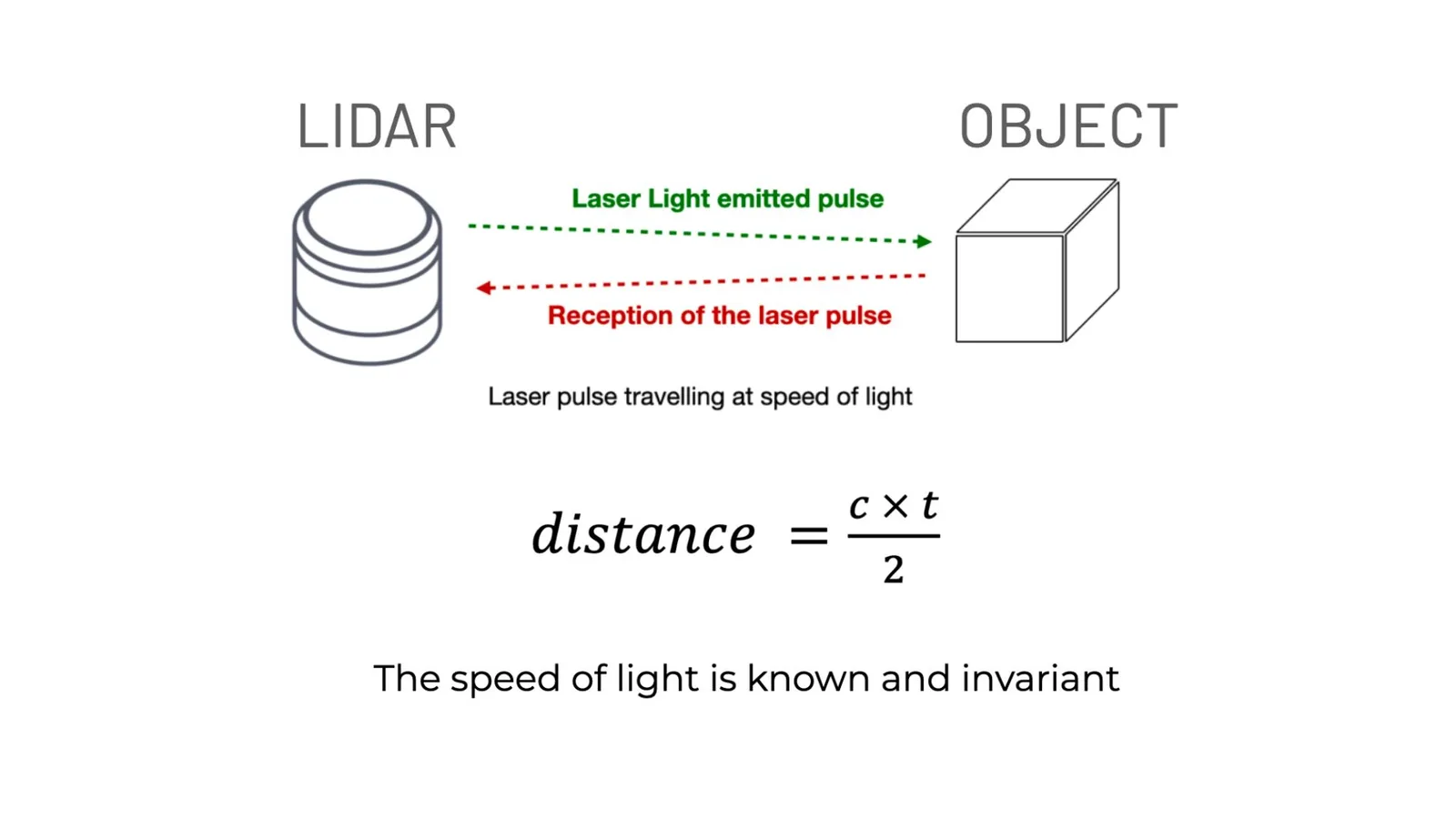
How does lidar work? by emitting laser light pulses to an object and measuring the distance between object and the lidar sensor

You can find more information in our article explaining these principles:

Understanding the basics of 3D LiDAR Technology

Light Detection and Ranging, also known as LiDAR, is a technology for remote sensing that is used to measure distances in an environment.

Read article →
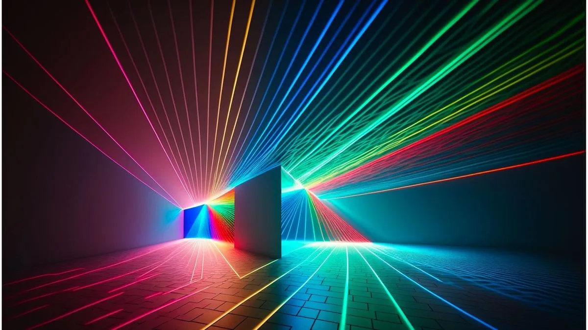
This LiDAR-generated spatial data is called “3D Point Cloud”, but cannot be used on its own. A LiDAR Processing software is needed to turn these raw data into 3D information.

That’s our mission at Outsight: to develop software solutions that allow Operators to access real-time actionable data from any LiDAR to help them manage their infrastructures.
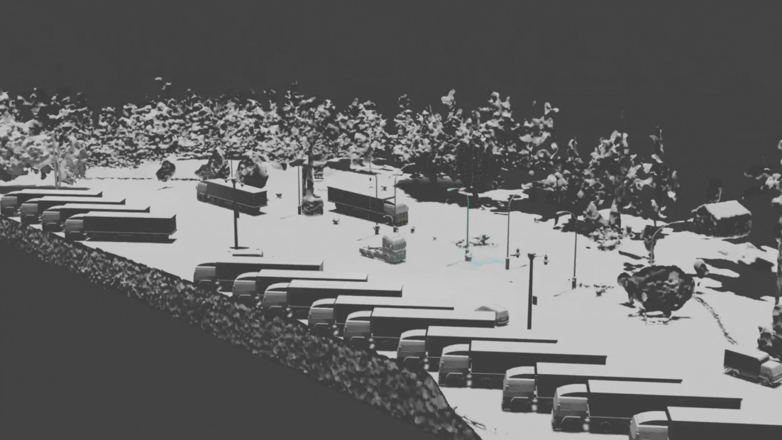
Lidar scan of parking lot

Why LiDAR for Parking Monitoring ?

With proper processing software, LiDAR can analyse people and vehicle flow throughout complex environments in real-time.

On one hand, this provides users with instant updates on the availability of parking spaces and traffic condition : they can effortlessly find vacant spots and avoid congestion while navigating a Parking Lot.

On the other hand, Parking Operators are accessing a whole new level of Spatial Information that enables them to make data-driven decisions not only to optimize space and resources allocation, but also streamline operations for superior efficiency.

Unlike traditional monitoring technologies that are vulnerable to rain, fog, or low-light environments, LiDAR excels in adverse conditions.

Moreover, a small number of sensors is enough to analyze large areas.

Thanks to its long-range detection capabilities, covering a parking area requires between 3 and 10 times fewer LiDAR devices compared to cameras.
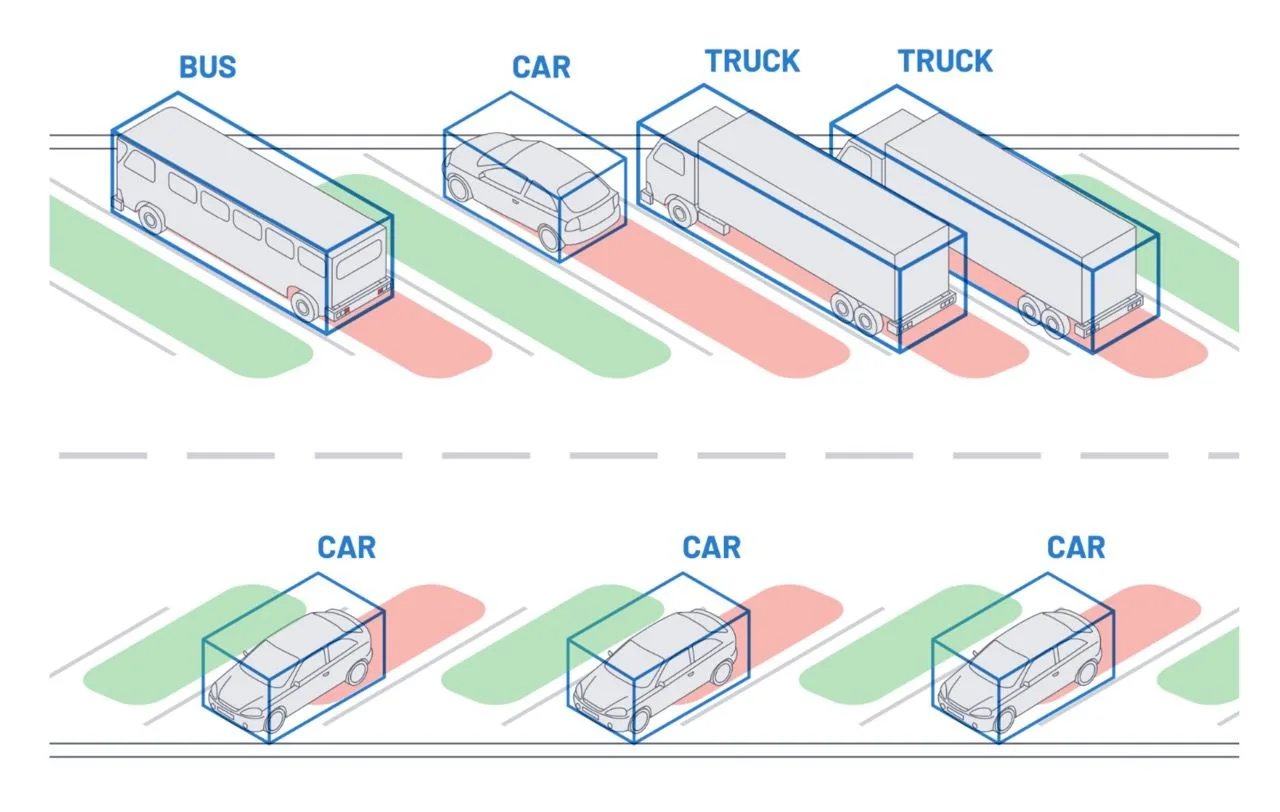
Diagram of vehicles with labeled boxes illustrating a smart vehicle detection system for parking management

With advanced software like Outsight’s, LiDAR can provide not only the presence of parked cars, but a whole set of comprehensive analytics

Where to start ?

Every parking facility has its unique requirements and configurations ranging from compact car spaces to very large truck zones and multi-level parking structures.

Depending on the size of the area that needs coverage, or the type and number of objects your want to track, some LiDAR sensors are more suitable than others.

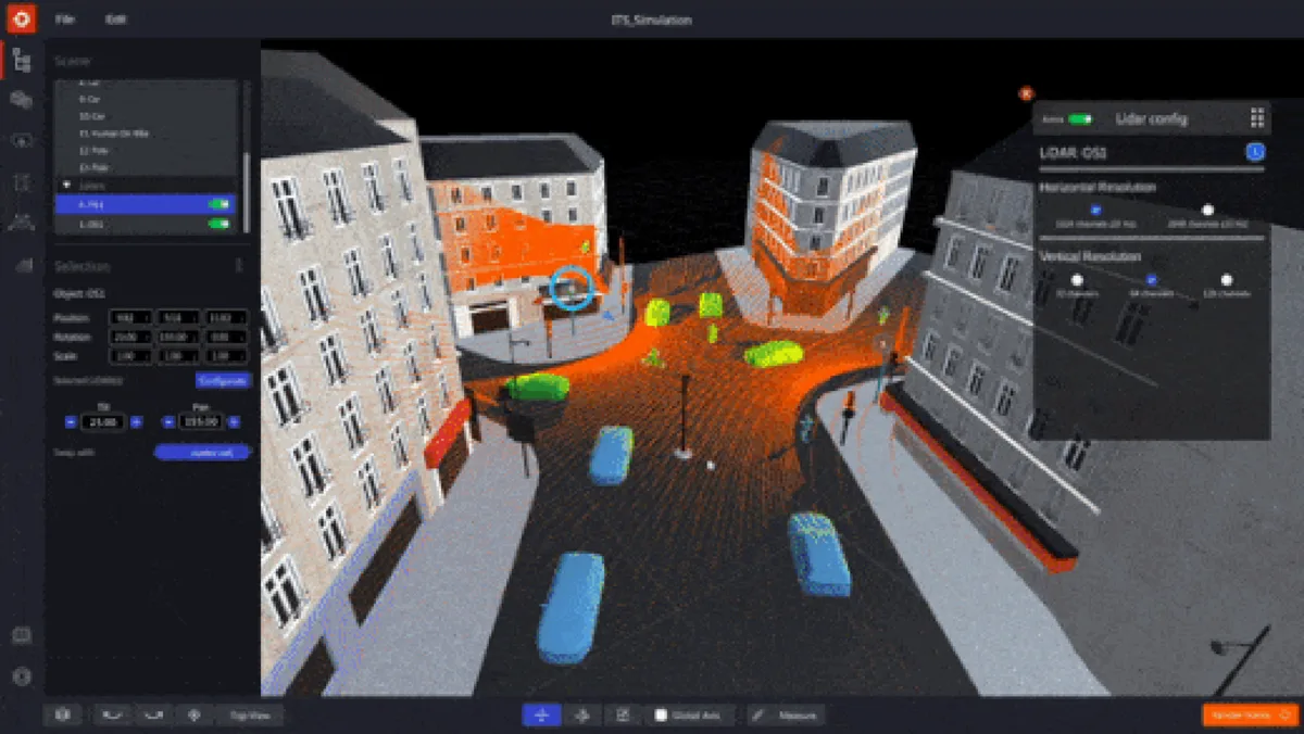
And what better way to choose from all of the manufacturers than our Outsight’s Spatial Intelligence Platform ?

Not only does our simulator recommends the most suited type of sensor for any specific needs, but the number needed as well as their most efficient position and orientation !

Discover our simulator right here :

First Multi-Vendor 3D LiDAR Simulator Unveiled

Outsight has developed a LiDAR simulator for any use case and application, from airports to mobile robotics, smart cities and industrial applications.

Read article →
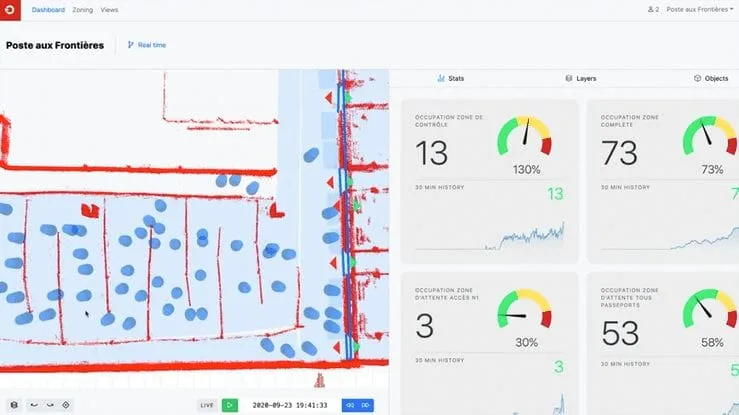
Our Plug & Play solution then centralizes the data from any sensor under a single customizable interface with specifics KPI.
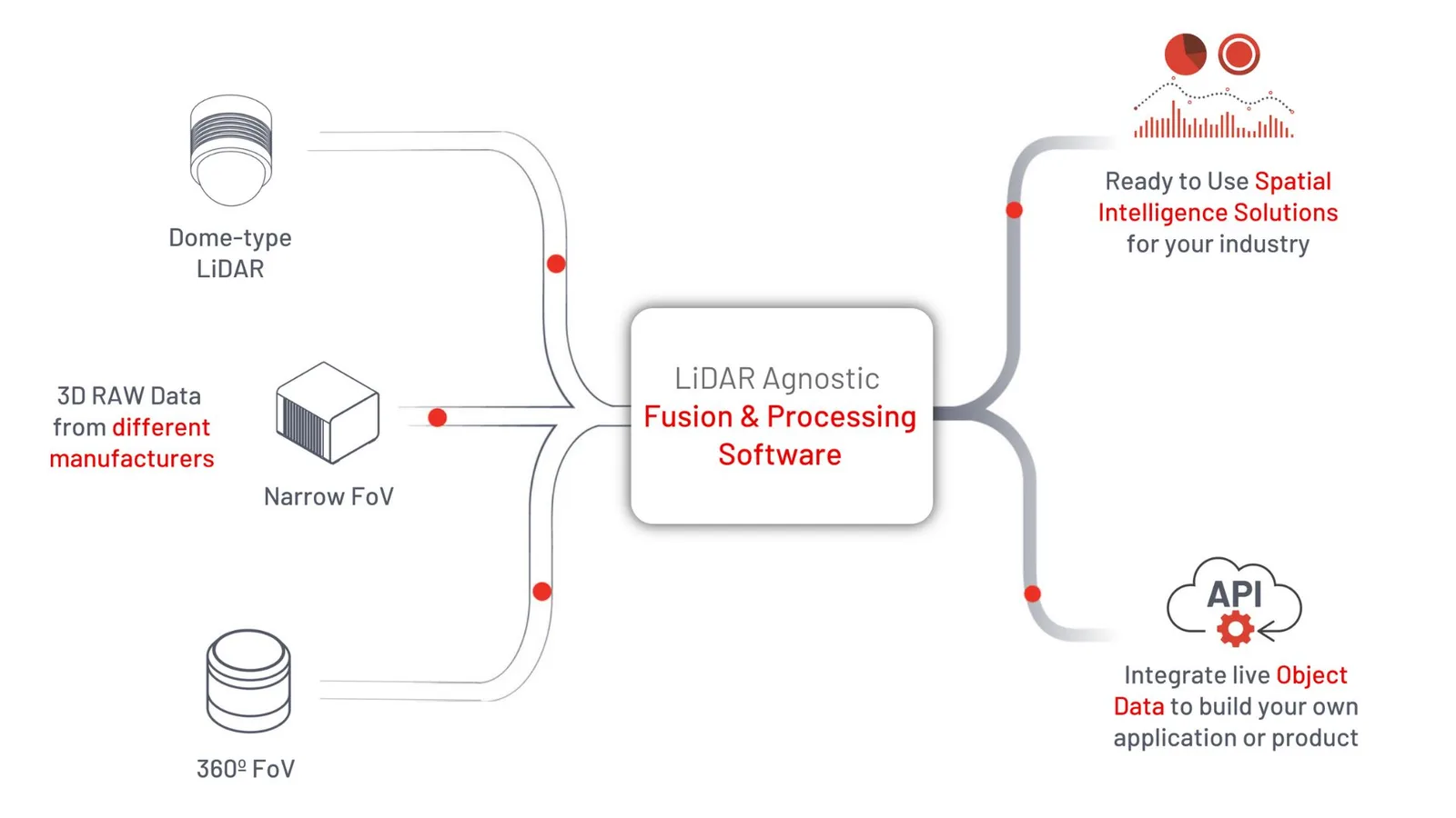
How Outsight uses 3D raw data and transforms it into Spatial Intelligence solutions

We give Operators all the tools they need to increase not only Users’ safety and experience, but Infrastructure security and operational efficiency as well.

Conclusion

LiDAR-based parking occupancy monitoring is revolutionizing the way Parking Lots are managed and utilized.

With its unparalleled accuracy, real-time monitoring capabilities, adaptability, and weather independence, LiDAR technology offers a high performing, cost effective solution that outperforms traditional sensors in providing accurate and reliable parking occupancy information.

To optimize the deployment of relevant LiDAR installations, we have assembled the most experienced team of LiDAR specialists.

We support our customers at every stage of their projects by providing them with the most advanced solutions on the market.
Related Articles

SECURITY

LiDAR: a new Era for flow monitoring in Airports

LiDAR is a game changer technology enabling a whole new level of situation awareness in many airport contexts, from security to operational excellence.

APPLICATIONS

LiDAR in Public Spaces: Top 6 Key Advantages for Improved Operations and Maintenance

Discover the benefits of LiDAR technology in public spaces: people counting, anonymity, public safety, easy installation, and error-free data.

Let's connect

Send us a Message

Drop your email and we'll get back to you as soon as possible.

Frequently Asked Questions

  • How many LiDAR sensors does a parking lot actually need compared to cameras?

    LiDAR's long-range detection means a parking area requires between 3 and 10 times fewer devices than a camera-based system covering the same footprint. Fewer sensors translate directly into lower installation, cabling, networking, and maintenance costs. The exact count depends on ceiling height, lot geometry, and whether the deployment needs to distinguish vehicle types such as motorcycles, standard cars, or trucks. Outsight's infrastructure-based approach, where LiDAR sensors are fixed in the environment rather than mounted on vehicles, maximizes each sensor's coverage volume and further reduces the hardware count needed to build a real-time 3D picture of the entire parking environment through the SHIFT platform.

  • Can LiDAR track trucks and oversized vehicles in a parking lot the same way it tracks cars?

    Yes. A 3D LiDAR system classifies objects by their point-cloud shape and dimensions rather than by a 2D image, so it can distinguish a standard car bay from a large truck zone by the bounding-box volume of the detected object. Outsight's Motional Digital Twin applies exactly this principle at infrastructure scale, generating real-time 3D bounding boxes for every vehicle type, from compact cars to articulated trucks, without requiring any sensor on the vehicles themselves. This matters for multi-use facilities where mixed-vehicle zones require separate occupancy counts and different space-allocation rules, allowing operators to enforce zone compliance and optimize throughput across the full range of vehicle classes present on site.

  • Does LiDAR parking monitoring work in an underground garage with no natural light?

    LiDAR is an active sensor: it emits its own laser pulses and measures their return, so ambient light levels have no effect on performance. Underground garages, night-time surface lots, and enclosed multi-story structures all fall within the same operational envelope as open-air daytime deployments. This is a structural difference from camera-based systems, which degrade when lighting is uneven or absent. Outsight's infrastructure-based approach relies on this property directly, deploying LiDAR sensors in the fixed environment rather than on vehicles, enabling consistent 3D tracking of people and vehicles across parking facilities regardless of whether natural light is present at all.

  • What analytics beyond simple space occupancy can a LiDAR parking system produce?

    Beyond binary occupied/vacant status, a LiDAR-based system can report dwell time per space, vehicle flow paths through the lot, near-miss events between pedestrians and moving vehicles, queue length at entry and exit lanes, and throughput rates. Outsight's SHIFT platform extends this further by building a real-time Motional Digital Twin of the entire parking environment, tracking how every person and vehicle moves through the space anonymously, without capturing faces or license plates. These layered metrics let operators identify underused zones, adjust pricing or signage, and benchmark real utilization against leased-capacity assumptions, turning a parking lot into a continuously optimized operational asset.

  • How does a smart parking system connect to driver-facing guidance displays or mobile apps?

    The spatial data pipeline typically exposes occupancy counts and zone-level availability via a REST or MQTT API. Downstream consumers, such as variable-message signs at lot entrances, navigation apps, or facility management dashboards, subscribe to that feed and update in near real time. Outsight's SHIFT platform follows this same open-integration model, publishing LiDAR-derived occupancy data through standard interfaces so operators can connect existing signage or third-party mobility apps without rearchitecting their stack. Because the underlying sensor layer runs at sub-50ms end-to-end latency, the bottleneck for driver-facing updates is usually the display refresh cycle, not the detection layer.

  • How does LiDAR-based parking monitoring help reduce fuel waste and emissions from vehicles searching for spaces?

    Studies on urban parking congestion consistently find that a material share of city-center traffic at any given time consists of drivers circling to find a space. Providing real-time occupancy data at zone or even bay level reduces that search time, cutting idling and circulation distance per visit. LiDAR enables this at the precision level cameras struggle to match in mixed-lighting conditions, making it applicable to the covered and underground facilities where the problem is most concentrated. Outsight's infrastructure-based approach, which processes 3D LiDAR data through the SHIFT platform in under 50 milliseconds, allows operators to deliver accurate, bay-level occupancy status continuously, regardless of lighting or weather, which is exactly the condition set where conventional camera systems degrade and search-related emissions tend to be highest.

  • What problems do traditional parking monitoring technologies create for drivers and operators?

    Traditional parking monitoring technologies struggle to deliver real-time actionable insights, especially in challenging lighting and weather conditions. This leads to safety hazards, increased traffic congestion, wasted time and fuel for drivers, and revenue loss for parking facility operators. With the growing number of vehicles on the roads, parking management has become an unavoidable challenge for smart cities, and LiDAR with processing software offers a cost-effective, high-performing answer.

  • How does a LiDAR sensor measure where cars are in a parking lot?

    LiDAR, originally developed for the automotive industry, uses laser beams to measure distances with an unprecedented level of accuracy. The sensor sends out a laser beam and measures the time it takes to bounce back from an object, which gives the distance between the LiDAR and that object. The resulting spatial data, called a 3D point cloud, is then turned into 3D information by LiDAR processing software. With software like Outsight's, LiDAR provides the presence of parked cars and a whole set of comprehensive analytics.

  • What is a 3D point cloud and why does parking monitoring need software to use it?

    A 3D point cloud is the spatial data generated by a LiDAR sensor, which measures distances by timing how long its laser beam takes to bounce back from objects. On its own, this raw data cannot be used to manage a parking facility. LiDAR processing software is needed to turn it into 3D information. Outsight's mission is to develop software solutions that allow operators to access real-time actionable data from any LiDAR to help them manage their infrastructures.

  • How does LiDAR parking monitoring help drivers and parking operators in different ways?

    With proper processing software, LiDAR analyzes people and vehicle flows in real time. Drivers receive instant updates on parking space availability and traffic conditions, so they can find vacant spots easily and avoid congestion inside the lot. Parking operators gain a new level of spatial information that supports data-driven decisions to optimize the allocation of space and resources and to streamline operations for greater efficiency. Both groups benefit from the same real-time data stream.

  • How does a multi-vendor LiDAR simulator help design a parking lot monitoring installation?

    Outsight's multi-vendor LiDAR simulator recommends the most suitable type of sensor for a parking facility's specific needs. It also indicates how many sensors are needed and their most efficient position and orientation. This helps operators choose among LiDAR manufacturers, whether the site has compact car spaces, very large truck zones or multi-level parking structures. Thanks to its long-range detection, covering a parking area requires between 3 and 10 times fewer LiDAR devices compared to cameras.

  • Which factors decide the right LiDAR sensor for a particular parking facility?

    Every parking facility has unique requirements and configurations, ranging from compact car spaces to very large truck zones and multi-level parking structures. The size of the area that needs coverage and the type and number of objects to track determine which LiDAR sensors are most suitable. Outsight's Spatial Intelligence Platform helps compare sensors across manufacturers and recommends the type, number, position and orientation for each site.

  • How is parking data from multiple LiDAR sensors centralized and presented to operators?

    Outsight's Plug and Play solution centralizes the data from any sensor under a single customizable interface with specific KPIs. With advanced software like Outsight's, LiDAR provides the presence of parked cars along with a whole set of comprehensive analytics, such as instant updates on space availability and traffic conditions. Outsight positions this as giving operators all the tools they need to increase users' safety and experience, as well as infrastructure security and operational efficiency.

  • Does rain or fog affect the accuracy of LiDAR parking occupancy monitoring?

    LiDAR excels in adverse conditions, while traditional monitoring technologies are vulnerable to rain, fog or low-light environments. Its unparalleled accuracy, real-time monitoring capabilities, adaptability and weather independence make it a solution that provides accurate and reliable parking occupancy information. A small number of sensors is also enough to analyze large areas: thanks to long-range detection, covering a parking area requires between 3 and 10 times fewer LiDAR devices compared to cameras.

  • Can a LiDAR parking system monitor pedestrians as well as vehicles?

    Yes. With proper processing software, LiDAR analyzes both people and vehicle flows throughout complex environments in real time. In a parking lot this means operators can follow how drivers and pedestrians move, alongside space occupancy. Outsight's software uses these insights to help operators improve user safety and experience, infrastructure security and operational efficiency, all from the same LiDAR installation. Beyond the presence of parked cars, Outsight's software provides a comprehensive set of analytics.

  • What support is available to parking operators deploying LiDAR monitoring?

    Outsight has assembled a team of experienced LiDAR specialists to help optimize the deployment of relevant installations. It supports customers at every stage of their projects, from choosing sensors with its multi-vendor simulator to processing the data and delivering KPIs through a single interface. The goal is a high-performing, cost-effective parking occupancy solution that provides accurate and reliable information in any lighting or weather.

  • What is the best way to monitor parking space occupancy in real time?

    Real-time parking monitoring needs to know which spaces are free and how vehicles move through the facility, indoors or outdoors. 3D LiDAR detects each vehicle's position and size precisely, so one sensor can monitor many spaces at once and also count flows at entrances and exits. Occupancy by space and zone is then published to guidance systems, apps or dashboards. Outsight's platform supports parking monitoring and uses a simulator to plan sensor positions for full coverage.