Skip to content
Insights
Outsight Innovusion Partnership

New Partnership Agreement Between Outsight and Innovusion

The goal of this new partnership is focused on accelerating LiDAR technology in the ITS market.


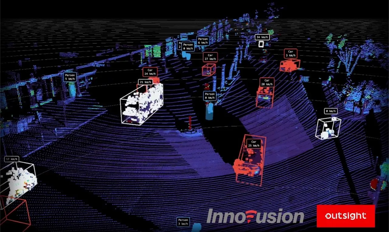
Outsight, a specialist in 3D Spatial Intelligence Software Solutions, and Innovusion, a leading provider of advanced, high-performance LiDAR systems, today announced a new partnership aiming to combine Outsight’s software platform with Innovusion’s products. Thanks to this partnership, 3D perception technologies can be deployed at a large scale for ITS, giving operators access to a whole new dimension of spatial information.
Innovusion x1 speed 2

Innovusion, a leading provider of high-performance LiDAR systems for autonomous vehicles and smart transportation, will be a key partner in Outsight’s mission to expand the adoption of 3D LiDAR technology. This collaboration aims to integrate Outsight’s software platform with Innovusion’s product suite, marking a significant stride towards deploying 3D perception technologies on a large scale for Intelligent Transportation Systems (ITS).

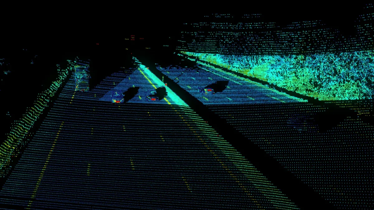
Innovusion is shaping the future of safe autonomous driving and system solutions aimed at enhancing mobility safety through its image-grade LiDAR solutions. Featuring top-of-the-line LiDAR sensors that stretch from mid-range to ultra-long range, Innovusion has not only found resonance within the automotive sector but has also forged global partnerships with vehicle manufacturers, technology multinationals, and leaders in smart transportation and industrial automation sectors.
Outsight innovusion partnership

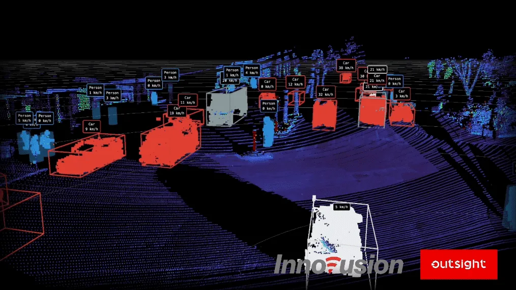
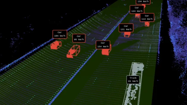
Outsight’s software solutions transform raw data from 3D LiDAR into actionable insights, analyzing in real time the individual position, movement, and speed of people, objects, and vehicles in a fully anonymous way throughout complex environments, including densely populated areas. Outsight’s software is engineered to make LiDAR technology more accessible and swiftly usable across a multitude of sectors, paving the way for enhanced situational awareness in dynamic and challenging environments.

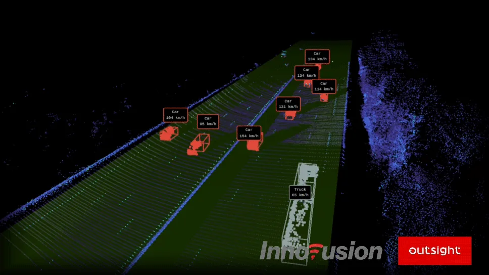
This partnership between Innovusion and Outsight is driven by a shared vision of accelerating the adoption of LiDAR technology in the Infrastructure ITS market. The synergy between Innovusion’s advanced LiDAR solutions and Outsight’s robust software sets the stage for a transformative journey towards harnessing 3D perception technologies to bring new design intelligence and modern detection methods to intersections and highways, increasing the safety of vehicles, pedestrians and vulnerable road users across the globe.
Innovusion Seyond Highway

A unique collaboration between software and hardware specialists

Innovusion’s hardware capability and Outsight’s software know-how are combined in this partnership, creating a symbiotic tech-ecosystem favorable for ground-breaking ITS solutions. The companies are taking a significant step toward developing smarter, safer, and more effective transportation systems with the combination of Innovusion’s high-precision LiDAR technology and Outsight’s skill at transforming 3D LiDAR data into practical insights.

Following this partnership, Innovusion and Outsight will collaborate to ensure the best integration between the latest innovations and products of each company.

According to Raul Bravo, President and Founder of Outsight, “We’re excited by the potential of our collaboration with Innovusion. Long-range 1550nm LiDAR certainly has a bright future, and now our customers and partners can leverage this high-resolution data as actionable information.”

“We’re thrilled to be collaborating with Outsight,” said Junwei Bao, CEO and co-founder of Innovusion. “Our partnership displays the commitment of both parties to furthering the adoption of innovative perception technologies like LiDAR in the ITS industry. Together with Outsight, we’re enabling the development of smarter and more efficient transportation systems across the globe.”
Related Articles

APPLICATIONS

New Partnership Agreement Between Outsight and Seyond

The aim of this collaboration is to accelerate the advancement of LiDAR technology within the ITS market.

APPLICATIONS

Innoviz and Outsight announce partnership to accelerate LiDAR's adoption in industries and smart cities

The combination of Outsight and Innoviz's solutions is intended to make 3D LiDAR technology more accessible and faster to use outside of the ADAS market.

Let's connect

Send us a Message

Drop your email and we'll get back to you as soon as possible.

Frequently Asked Questions

  • What is Innovusion's LiDAR range and why does it matter for ITS deployments?

    Innovusion produces LiDAR sensors spanning mid-range to ultra-long range, which is a meaningful distinction for ITS. Short-range sensors suited to indoor pedestrian tracking cannot reliably detect vehicles at highway approach speeds before a decision point. Ultra-long-range coverage allows a single sensor to observe a vehicle far enough in advance to classify it, measure its speed, and flag any interaction with vulnerable road users before the vehicle reaches the monitored zone. This range capability aligns with the infrastructure-based approach that Outsight applies through its SHIFT platform, where sensors deployed at fixed positions in the environment need sufficient reach to feed a real-time Motional Digital Twin of every vehicle and pedestrian moving through a corridor or intersection.

  • How does 1550nm LiDAR differ from 905nm LiDAR for traffic applications?

    The 1550nm wavelength sits in a region where the human eye is far less sensitive, allowing sensors to emit more optical power within eye-safety limits than 905nm designs. More power at a safe level translates directly into longer detection range and better performance in adverse conditions such as rain, direct sunlight glare, or headlight interference from oncoming vehicles. For highway-speed traffic monitoring, where detection range determines reaction time, this wavelength advantage is operationally significant. Outsight's infrastructure-based approach, which processes LiDAR point clouds through the SHIFT platform with a sub-50ms end-to-end pipeline, is designed to take full advantage of higher-range sensors like 1550nm units in demanding ITS environments.

  • What does 'image-grade' LiDAR mean in practice for road safety applications?

    Image-grade LiDAR refers to sensors with point-cloud density high enough that the spatial resolution approaches photographic detail. At that density, a system can resolve fine-grained object shapes at long range, distinguishing, for example, a cyclist from a scooter or a pedestrian pushing a pram from one walking alone. Standard-density LiDAR resolves blobs reliably at short range but loses classification fidelity at distance, which matters for vulnerable-road-user detection on high-speed roads. Outsight's infrastructure-based approach processes these dense point clouds through a sub-50ms pipeline, enabling real-time classification without relying on camera-based biometric data, a combination that makes image-grade resolution practically useful in ITS deployments where both speed and privacy compliance are required.

  • Which road users are hardest to detect reliably with LiDAR at highway intersections?

    Vulnerable road users, including cyclists, pedestrians, and motorcyclists, are the most challenging class to detect reliably. Their LiDAR return size is small relative to vehicles, they move unpredictably, and they most often appear at the margins of the detection zone where sensor coverage is thinnest. Infrastructure-based LiDAR addresses this partly by placing sensors overhead or at angles that maximize the return area from smaller objects, rather than relying on a ground-level perspective. Outsight's infrastructure-based Physical AI approach, deployed at smart-city intersections such as those in the City of Bellevue's Vision Zero program, applies this principle at scale, using the Motional Digital Twin to track and classify all road users in real time, including the most vulnerable ones.

  • Can a LiDAR-based ITS system feed variable message signs or signal controllers in real time?

    Yes. ITS deployments typically expose tracked-entity data and aggregated traffic metrics through standard protocols such as NTCIP, REST APIs, and MQTT, which signal controllers and variable message sign systems already accept. The sub-50ms end-to-end latency of a real-time LiDAR pipeline is well inside the decision cycle of adaptive signal control systems, which typically operate on multi-second intervals. Outsight's SHIFT platform is built around this kind of open integration approach, publishing live perception output to downstream traffic management systems without requiring changes to the signal or signage infrastructure. The integration burden falls on the middleware layer, not on the sensor or perception stack.

  • Does combining LiDAR with cameras at a traffic intersection improve detection accuracy?

    LiDAR and cameras address different weaknesses in each other. LiDAR delivers precise 3D position, speed, and trajectory without depending on lighting conditions, but provides no color or texture information. Cameras supply color (useful for license-plate reading and signal-state verification) but lack native depth. In a fused setup, the LiDAR track provides a persistent anonymous ID and spatial reference, while camera attributes are optionally attached to that ID. This is the architecture Outsight applies at smart-city intersections: infrastructure-mounted LiDAR builds the core spatial track through the SHIFT platform, and camera feeds can be integrated as supplementary attribute layers. Neither sensor alone matches the combined classification confidence of both working together.

  • When was the Innovusion partnership announced and what market does it target?

    Outsight and Innovusion announced their partnership in November 2023. The agreement targets the Infrastructure Intelligent Transportation Systems (ITS) market and is driven by a shared vision of accelerating the adoption of LiDAR technology there. By combining Outsight's software platform with Innovusion's product suite, the two companies aim to deploy 3D perception technologies at large scale for ITS, giving operators access to a whole new dimension of spatial information.

  • What does each company bring to the Innovusion ITS partnership?

    The partnership combines Innovusion's hardware capability with Outsight's software know-how. Innovusion provides high-precision, image-grade LiDAR sensors ranging from mid-range to ultra-long range, while Outsight contributes its Spatial Intelligence software, which transforms raw 3D LiDAR data into actionable insights. Together they form what the companies describe as a symbiotic tech ecosystem for ITS, aimed at developing smarter, safer and more effective transportation systems.

  • What road information does the spatial intelligence software extract from Innovusion LiDAR data?

    Outsight's software transforms raw 3D LiDAR data into actionable insights, analyzing in real time the individual position, movement and speed of people, objects and vehicles. It does this in a fully anonymous way throughout complex environments, including densely populated areas. The partnership integrates this software with Innovusion's product suite, and Raul Bravo, President Founder of Outsight, said customers and partners can now leverage long-range 1550nm LiDAR data as actionable information.

  • Which industries does Innovusion work with besides intelligent transportation systems?

    Innovusion is a leading provider of high-performance LiDAR systems for autonomous vehicles and smart transportation. Its image-grade LiDAR solutions have found strong resonance within the automotive sector, and the company has forged global partnerships with vehicle manufacturers, technology multinationals, and leaders in smart transportation and industrial automation. Through its partnership with Outsight, Innovusion extends this reach into infrastructure-based ITS deployments at intersections and highways.

  • What did Raul Bravo say about the partnership with Innovusion?

    Raul Bravo, President Founder of Outsight, said the company was excited by the potential of its collaboration with Innovusion. He stated that long-range 1550nm LiDAR certainly has a bright future, and that with this partnership Outsight's customers and partners can leverage this high-resolution data as actionable information. His comment reflects the partnership's core idea: pairing Innovusion's high-performance sensors with Outsight's Spatial Intelligence software for ITS.

  • What did Innovusion CEO Junwei Bao say about the partnership?

    Junwei Bao, CEO and co-founder of Innovusion, said the company was thrilled to be collaborating with Outsight. He described the partnership as a display of both parties' commitment to furthering the adoption of innovative perception technologies such as LiDAR in the ITS industry. According to him, together with Outsight, Innovusion is enabling the development of smarter and more efficient transportation systems across the globe. The partnership pairs Innovusion's image-grade LiDAR with Outsight's software for turning 3D data into actionable insights.

  • How will the two companies keep their products integrated after the partnership?

    Following the partnership agreement, Innovusion and Outsight will collaborate to ensure the best integration between the latest innovations and products of each company. The partnership aims to integrate Outsight's software platform with Innovusion's product suite. The companies present this as a significant stride towards deploying 3D perception technologies on a large scale for Intelligent Transportation Systems, bringing new detection methods to intersections and highways.

  • Can people be tracked anonymously in dense areas using Innovusion LiDAR sensors?

    Yes. Outsight's software analyzes the individual position, movement and speed of people, objects and vehicles in a fully anonymous way throughout complex environments, including densely populated areas. Paired with Innovusion's image-grade LiDAR sensors, this allows ITS operators to gain detailed situational awareness at intersections and on highways while protecting privacy. The data is turned into actionable insights in real time, supporting safety for vehicles, pedestrians and vulnerable road users.

  • How can the Innovusion partnership improve safety at intersections and highways?

    Outsight and Innovusion aim to harness 3D perception technologies to bring new design intelligence and modern detection methods to intersections and highways. Innovusion's high-precision LiDAR captures the scene, and Outsight's software converts it in real time into the position, movement and speed of each road user. The companies state that this combination is intended to increase the safety of vehicles, pedestrians and vulnerable road users across the globe.

  • Why is making LiDAR more accessible a focus of the Innovusion deal?

    Outsight's software is engineered to make LiDAR technology more accessible and swiftly usable across a multitude of sectors. It transforms raw 3D LiDAR data into actionable insights, paving the way for enhanced situational awareness in dynamic and challenging environments. In the partnership with Innovusion, this software know-how is combined with Innovusion's high-precision LiDAR to deploy 3D perception technologies at large scale for Intelligent Transportation Systems.