Skip to content
Insights
Outsight, Advantech, and Intel Unite to Launch a Smart Cities Solution

Outsight, Advantech, and Intel Unite to Launch a Smart Cities Solution

Outsight's Smart Cities solution in partnership with Intel & Advantech harnesses LiDAR tech for precision in urban management, enhancing safety and efficiency in high-traffic areas.


We are thrilled to announce a groundbreaking partnership between Outsight, Advantech, and Intel to deliver an innovative Smart Cities solution powered by LiDAR-based Spatial Intelligence.

This collaboration leverages the expertise and cutting-edge technology of each partner to address the growing demand for advanced urban mobility management and safety solutions.

The Technology

Our Smart Cities solution leverages LiDAR (Light Detection and Ranging) technology, which offers unparalleled precision in spatial measurements by using laser light to create detailed 3D maps of environments.

Overview of the technology partnership for Smart Cities & Urban Mobility

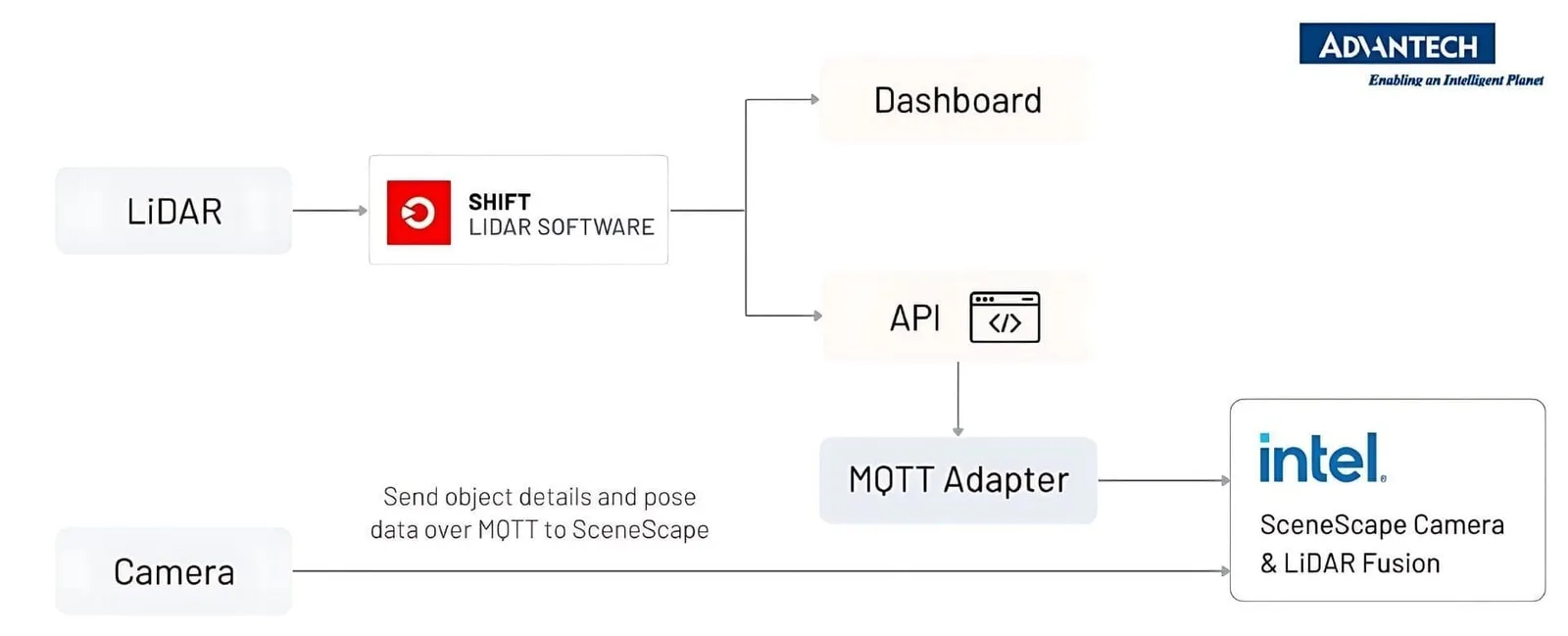
LiDAR sensors and cameras are connected to the Intel Core processor-based Advantech MIC 770 PC which runs the Outsight’s Spatial Intelligence Platform.

While LiDAR uses the CPU cores, Intel SceneScape uses the integrated GPU to perform video analytics on the camera frames and then the output from both is
merged together to create a live digital twin.

This technology is essential for understanding and optimizing high-traffic areas, ensuring safety, and enhancing operational efficiency.

Key Components

Outsight’s SHIFT LiDAR Software

  • Comprehensive Spatial AI Solution: The software uses advanced 3D LiDAR data processing techniques to provide accurate real-time tracking of vehicles and pedestrians.
  • High Privacy Standards: Ensures complete privacy by processing data in a way that does not capture personally identifiable information.
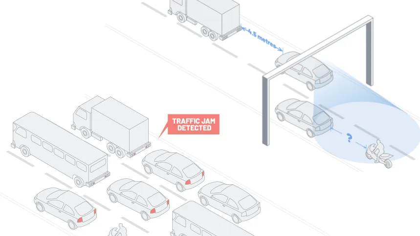
  • Versatile Applications: Suitable for various smart transportation applications, including automatic incident detection, safe distance monitoring, traffic flow measuring, vulnerable road user safety, and parking occupancy monitoring.

The Role of LiDAR in Intelligent Transportation Systems

Intelligent Transportation Systems (ITS) are crucial for enhancing road safety and efficiency. LiDAR brings these systems to a whole new level.

Read article →

  • Robust Performance: Compact, fanless PCs designed for harsh outdoor conditions, equipped with high-performance Intel® Core™ processors.
  • Wide Operating Temperature Range: Features like IP40 weatherproofing for reliable operation in various environments.

Intel’s Advanced Technologies

  • 14th Gen Intel® Core™ Processors: Enhanced for LiDAR, image, and AI inference processing with integrated Intel® UHD Graphics and Intel® Deep Learning Boost.
  • Intel® SceneScape: A multimodal scene intelligence software delivering sensor fusion to reach new levels of real-time spatial awareness.
  • Intel® Geti: A computer vision AI training platform for laborious data labeling and model training optimization.

Cédric Hutchings, co-founder and CEO of Outsight said

“We’re able to deliver this solution cost effectively thanks to our software that can be run on just a few CPU cores combined with the
high performance hardware from our partners Advantech and Intel.
Intel SceneScape, enabled by Intel Geti, opens new doors for sensor fusion applications”
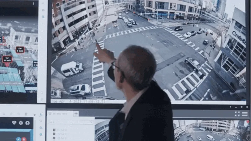
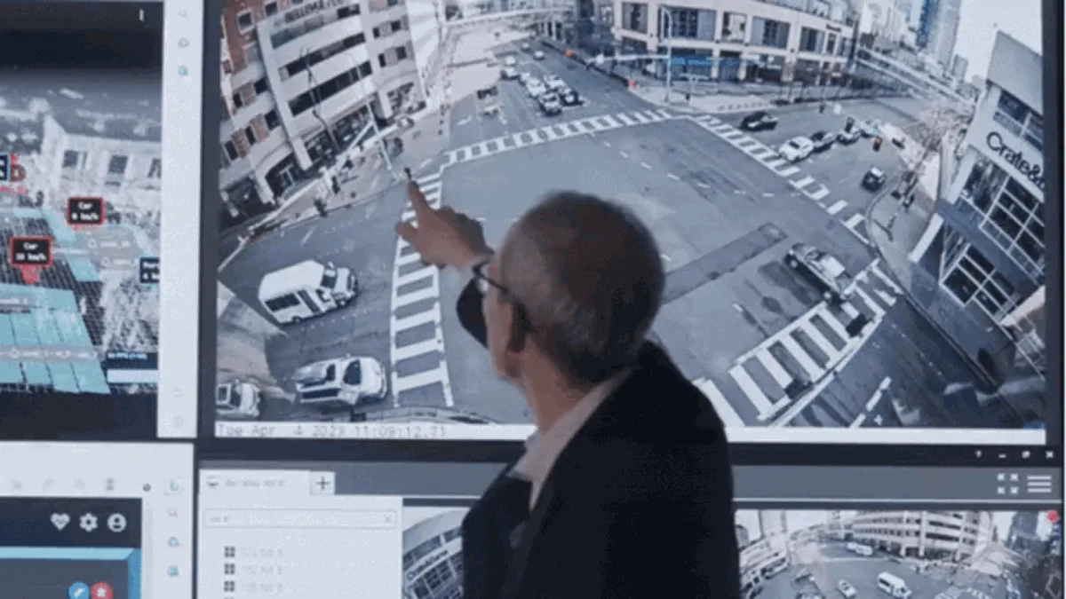
Real-World Impact

Our Smart Cities solution is already making strides in urban environments.

Making Bellevue safer with LiDAR Solutions

Discover Outsight’s latest use case in the city of Bellevue, a complete LiDAR installation to increase users’ safety at busy intersections!

Read article →

Advantages Over Conventional Solutions

  • Accuracy and Reliability: Provides detailed and precise spatial measurements, outperforming conventional 2D perception technologies.
  • Scalability and Flexibility: Uses a scalable LiDAR fusion architecture, requiring fewer sensors and reducing infrastructure and maintenance costs.
  • Privacy and Compliance: Ensures GDPR compliance with no personal data collection, addressing privacy concerns head-on.

Conclusion

The launch of our Smart Cities solution represents a leap in technological innovation, harnessing the power of LiDAR-based spatial intelligence to create safer, more efficient urban spaces.

We invite urban planners, transportation authorities, and smart city developers to explore the transformative potential of our solution and join us in shaping the future of smart urban living.

For more information about Outsight and its innovative solutions, please visit outsight.ai. Together, let’s make our cities smarter, safer, and more efficient.


Related Articles

AIRPORTS

Aeroporti di Roma to deploy Outsight's Physical AI solution at scale across Rome Fiumicino Airport

Aeroporti di Roma (ADR) is expanding its collaboration with Outsight to a large-scale deployment across almost all Schengen common-use areas at Rome Fiumicino Airport.

CORPORATE

Intel and Outsight Announce Strategic Collaboration to Bring Physical AI–Powered Spatial Intelligence to the Enterprise Edge

Outsight’s Shift platform integrated into Google Distributed Cloud Edge powered by Intel Xeon 6 SoC – Live demonstration at Google Cloud Next 2026

Let's connect

Send us a Message

Drop your email and we'll get back to you as soon as possible.

Frequently Asked Questions

  • What does a LiDAR and camera fusion setup actually look like at a smart city intersection?

    In a typical deployment, LiDAR sensors and cameras feed into a single edge PC. The LiDAR workload runs on CPU cores, producing 3D tracking of vehicles and pedestrians, while camera frames are processed in parallel on the integrated GPU for video analytics. The two streams are then merged into one live spatial scene. In the smart city solution developed by Outsight with Intel and Advantech, this split-processing architecture runs on compact, affordable hardware rather than requiring a dedicated AI accelerator for each sensor type. The result is a fused, real-time spatial view of an intersection that can support safety programs like Vision Zero, similar to how Outsight's SHIFT platform is applied at instrumented urban intersections such as those in the City of Bellevue.

  • Why run LiDAR processing on a CPU rather than a dedicated GPU or FPGA?

    LiDAR point-cloud processing is geometrically structured work: detecting, classifying, and tracking objects in 3D space across a sparse but ordered data stream. That workload maps efficiently onto modern CPU cores with wide SIMD instruction sets, unlike the dense pixel-grid operations that favor GPU parallelism. Outsight's SHIFT platform is built around this principle, running its sub-50ms end-to-end pipeline on CPU-based edge hardware without requiring a discrete graphics card. Keeping LiDAR processing on the CPU leaves the integrated GPU free for camera-based video analytics, so a single compact edge box handles both sensor modalities. In the Outsight, Advantech, and Intel smart cities deployment, this architecture lets infrastructure-mounted sensors deliver real-time 3D situational awareness at intersections and high-traffic urban areas within a practical, deployable form factor.

  • How does a smart city LiDAR deployment handle GDPR without anonymizing data after collection?

    LiDAR sensors emit laser pulses and measure surface returns: the output is a 3D point cloud of shapes and positions, not pixels. Faces, license plates, and biometric identifiers are physically impossible to record at any stage of the pipeline. Because no personal data enters the system, there is nothing to anonymize retroactively. GDPR compliance is therefore a structural property of the sensor physics rather than a downstream data-handling policy. Outsight's infrastructure-based approach to smart city deployments, including Vision Zero intersection monitoring for the City of Bellevue, is built on this principle: the Motional Digital Twin captures how people and vehicles move through a space, never who they are.

  • What is Intel SceneScape and how does it relate to LiDAR software?

    Intel SceneScape is a multimodal scene intelligence software layer that performs sensor fusion, combining inputs from cameras and other sensors into a unified real-time spatial representation. In the smart cities architecture developed with Outsight and Advantech, SceneScape handles video analytics on camera frames using the integrated GPU, while the Outsight SHIFT platform handles the 3D tracking workload on CPU cores. The two outputs are then merged to produce a single live scene rather than two disconnected data streams. This division of labor allows each processing layer to operate within its native compute domain, with LiDAR-derived 3D geometry and camera-derived visual context arriving as complementary inputs to a coherent operational picture.

  • How many sensors does a LiDAR-based smart intersection need compared to a camera-only setup?

    LiDAR's 3D field of view covers a wider area per unit than a flat 2D camera, because depth perception reduces the number of overlapping vantage points needed to eliminate blind zones. A scalable LiDAR fusion architecture, where multiple sensors share one point cloud, further reduces per-intersection sensor counts. Outsight applies this principle in its infrastructure-based deployments, such as the Vision Zero smart-city intersections in the City of Bellevue, where LiDAR sensors mounted in the infrastructure track pedestrians and vehicles across the full intersection volume without requiring the dense camera arrays a 2D setup would demand. The practical effect is lower hardware, cabling, and maintenance costs over the life of the deployment, though exact counts depend on intersection geometry and the specific sensor models used.

  • What smart city use cases go beyond traffic counting with LiDAR at intersections?

    Beyond vehicle throughput measurement, infrastructure-mounted LiDAR at intersections can support automatic incident detection (stopped vehicles, debris, collisions), safe-distance monitoring between road users, vulnerable road user safety alerts for cyclists and pedestrians, and parking occupancy monitoring in adjacent areas. The same sensor network that counts vehicles can trigger real-time alerts when a pedestrian enters a lane during a red phase or when a vehicle is stationary in a live traffic lane. Outsight applies exactly this range of use cases through its SHIFT platform, which powers Vision Zero-aligned deployments such as the City of Bellevue smart-city intersections, processing 3D motion data in real time without any camera feed or biometric capture.