Skip to content
Insights
Results from the evaluation of Bellevue's Phase Extension Pilot

Enhancing Intersection Safety: Bellevue's Vision Zero Initiative with Outsight's Technology

LiDAR technology is transforming pedestrian safety and setting benchmarks for Smart City Solutions. Discover how Bellevue, under its Vision Zero initiative, is leveraging Spatial AI to make the city a safer place for its citizens


The City of Bellevue, in the state of Washington in the USA, has been a front-runner in adopting cutting-edge technology for enhancing public safety and traffic management.

Committed to the Vision Zero initiative, which aims to eliminate traffic deaths and serious injuries by 2030.

Intersections represent significant zones for traffic-related incidents in the U.S. The Federal Highway Administration notes that annually, approximately one-quarter of traffic deaths and about half of all traffic-related injuries are linked to intersections.

An analysis of crash data from 2017 to 2021 reveals that 72% of pedestrian-related fatalities and severe injuries occurred at intersections in the City of Bellevue, Washington. Hence, the city’s council strategically focuses on intersections to implement high performing technology.

Since 2021, the city’s council has been leveraging Outsight’s 3D LiDAR data insights to enhance road safety for vulnerable road users (VRU).

This partnership is pivotal in transforming Bellevue into a smarter and safer city by leveraging advanced traffic control systems and situation awareness technologies.
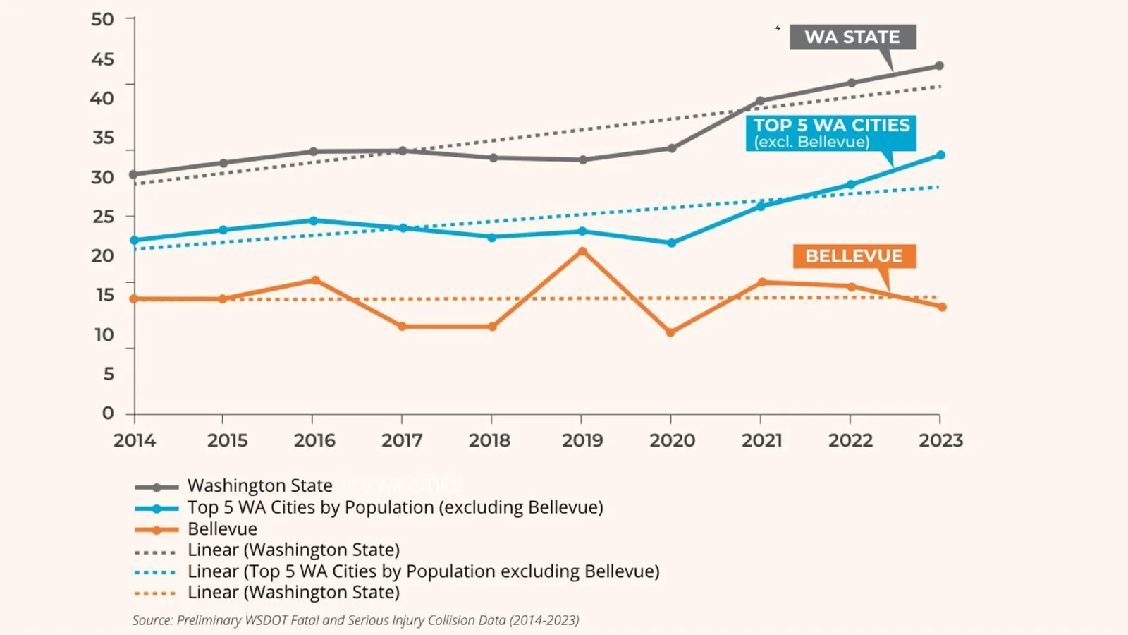
A comparative analysis of the trend of fatal and serious injury crashes in Bellevue and other cities in Washington from 2014-2023

Reduction in fatal and serious injury crashes is in the opposite direction of trends observed in other large cities and in the state of Washington.

The first collaboration between Bellevue and Outsight was aimed at implementing a High Visibility Crosswalk. The results from this project showed a significant 56.4% decrease in pedestrian-vehicle conflict.

Making Bellevue safer with LiDAR Solutions

Discover Outsight’s latest use case in the city of Bellevue, a complete LiDAR installation to increase users’ safety at busy intersections!

Read article →
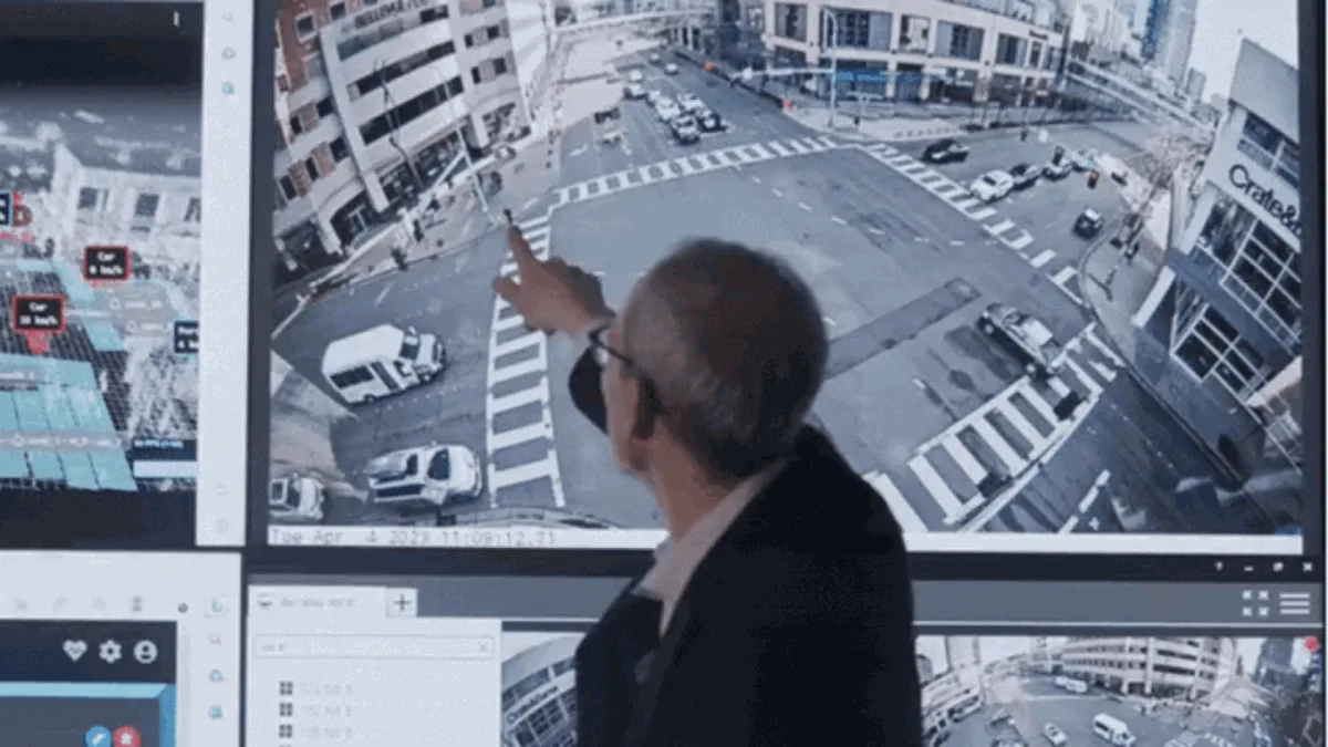
The new project, the Passive Pedestrian Detection Phase Extension, involves a sophisticated application of adaptive signal control tailored for pedestrian safety, utilizing LiDAR sensors alongside Outsight’s Spatial Intelligence Platform.

This pilot integrates Outsight’s 3D Perception Software with additional technologies from partners like Ouster, Amazon Web Services and Blue-Band.
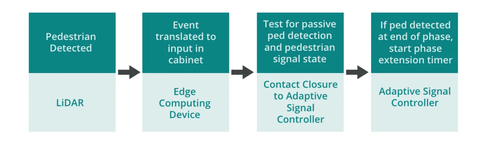
The steps showcasing the methodology of the implementation of the project

Diagram summarising the steps of the Passive Pedestrian Detection Phase Extension system.

These technologies work together to interpret complex traffic data in real-time, ensuring dynamic and efficient traffic management.

Outsight’s Spatial Intelligence Platform plays a crucial role in this Intelligent Transportation System (ITS) project. It is at the forefront for detecting and classifying various road users and identifying potential conflict points.

Specifically, this project assesses how LiDAR sensors at critical intersections can detect pedestrians and communicate with traffic control systems to adapt signal timings in real-time, enhancing pedestrian safety and optimizing traffic flow.

How did Bellevue implement this ?

Two Ouster LiDAR sensors were installed at the intersection of Bellevue Way and NE 8th Street: one on the northwest corner signal pole and one on the southeast corner pole.

The millions of points of raw data from these sensors were processed in real time by Outsight’s 3D Perception Software.

Outsight's Shift Perception Software transforms millions of raw data points from LiDAR sensors into actionable KPIs

Bellevue’s project team customised their Zones of Interest owing to Outsight’s Spatial Intelligence Platform.

Different zones were set up for pedestrians and vehicles. The pedestrian zones were drawn to be the width of the crosswalk and within a few feet of the curb.

Every time a “pedestrian detected” event was captured by Outsight’s 3D Computer Vision Software, it was translated to the traffic signal controller using the Integrator-AI platform by Blue-Band for an adaptive signal system used in the city.
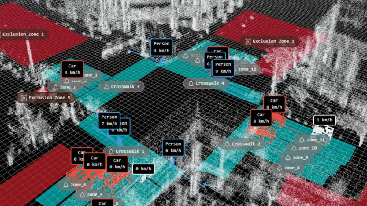
Outsight's 3D Spatial AI (also known as Physical AI) software tracking vehicles and pedestrians at a busy intersection

Outsight’s 3D Perception Software to track pedestrians and vehicles.

In the case of a pedestrian detected on the crosswalk just before the signal would turn yellow, it would add more time and the signal would remain green for a longer walk time, enabling the pedestrian to cross the road safely and avoid a collision.

Diagram showing the traffic signal intervals which were adjusted by input from Outsight's Spatial AI (also known as Physical AI) into the traffic signal

Diagram showing the traffic signal intervals.

The Results

The results highlighted the effectiveness and precision of the system in enhancing pedestrian safety. Below is a summary of the key findings from the evaluation:

  • Reduction in Vehicle-Pedestrian Conflicts: Utilizing Outsight’s Shift LiDAR Software led to a notable decrease in vehicle-pedestrian conflicts, enhancing the results achieved from the Leading Pedestrian Intervals pilot conducted in 2019
  • Enhanced Real-Time Response: The technology’s real-time data processing enabled immediate adjustments to traffic signal phases, which effectively responded to dynamic road conditions and pedestrian movements​​.
  • Accurate Metrics: The system consistently achieved high detection precision (70-97%) across various crosswalks and timeframes, accurately identifying pedestrians within the crosswalk zones with a minimal miss rate of less than 10%.
  • Impact on Traffic Flow: Analysis revealed a decrease in the percentage of time traffic was over-saturated (above 120% DS) with the phase extension in January 2024 compared to December 2023, suggesting minimal impact on traffic congestion due to the phase extensions.
  • Reinforces the Integration of LiDAR with other technologies: The evaluation reinforces the endless capabilities for integrating LiDAR data with other cutting-edge technologies like video analytics and advanced mobility analytics platforms, promising enhancements to urban traffic management systems.

You can access the full Bellevue Passive Pedestrian Detection Real-Time Safety Application Phase Extension Report by downloading the comprehensive report here.

Conclusion

In conclusion, Bellevue’s deployment of Outsight’s Shift LiDAR Software sets a new standard for intelligent traffic control systems worldwide.

This initiative not only enhances pedestrian safety but also showcases the scalability of AI in public safety applications, positioning Bellevue as a benchmark for smart city solutions.


The Role of LiDAR in Intelligent Transportation Systems

Intelligent Transportation Systems (ITS) are crucial for enhancing road safety and efficiency. LiDAR brings these systems to a whole new level.

Read article →
Sources

Diagram 1: _City of Bellevue (WA) Passive Pedestrian Detection Phase Extension Pilot Report
Diagram 2: _City of Bellevue (WA) Passive Pedestrian Detection Phase Extension Pilot Report

Related Articles

APPLICATIONS

Making City of Bellevue's Roads Safer: How Outsight's Software Changed the Game

Discover Outsight's latest use case in the city of Bellevue, a complete LiDAR installation to increase users' safety at busy intersections!

TECHNOLOGY

Transforming ITS: LiDAR vs Camera vs Radar

LiDAR, Cameras, and Radar are evolving Intelligent Transportation Systems, with LiDAR leading the way.

Let's connect

Send us a Message

Drop your email and we'll get back to you as soon as possible.

Frequently Asked Questions

  • What detection accuracy can LiDAR achieve for pedestrian tracking at intersections?

    Field results from the City of Bellevue deployment, where Outsight's infrastructure-based LiDAR technology supports the Vision Zero initiative, show detection precision ranging from 70% to 97% across different crosswalks and timeframes, with a miss rate below 10%. These figures vary by crosswalk geometry, sensor placement, and time of day. The range reflects real-world variability rather than controlled-lab conditions, which makes it a more meaningful benchmark for city traffic engineers evaluating the technology for Vision Zero programs. Because LiDAR captures shape and motion rather than faces or biometric data, the system delivers this accuracy while remaining anonymous by definition.

  • How does a passive pedestrian detection system differ from a push-button crosswalk signal?

    A push-button system relies on pedestrians actively requesting a signal extension, so it misses anyone who forgets, cannot reach the button, or arrives mid-cycle. A passive detection system uses sensors mounted in the infrastructure to identify when a pedestrian is present in the crosswalk zone automatically, extending the green phase without any action from the pedestrian. This approach is particularly relevant for elderly pedestrians, children, and wheelchair users who may cross more slowly. At Bellevue's Vision Zero intersections, Outsight deploys infrastructure-based LiDAR sensors that detect pedestrian presence and motion in real time, triggering signal adjustments anonymously without capturing any facial or biometric data.

  • What sensor hardware was used in the Bellevue intersection deployment?

    Two Ouster LiDAR sensors were installed at the intersection of Bellevue Way and NE 8th Street, one on the northwest corner signal pole and one on the southeast corner pole. Outsight's SHIFT platform processed the raw point-cloud data in real time, with signal control commands relayed through Blue-Band's Integrator-AI platform and cloud infrastructure provided by Amazon Web Services. This multi-vendor stack illustrates how infrastructure-mounted LiDAR integrates with existing traffic control equipment rather than replacing it, a pattern consistent with Outsight's infrastructure-based approach to Physical AI across smart-city and transportation deployments.

  • Does extending a pedestrian signal phase cause measurable traffic congestion?

    Analysis from the Bellevue pilot found a decrease in the percentage of time traffic operated above 120% degree of saturation after the phase extension system became active, comparing January 2024 with December 2023. The result suggests that adaptive phase extensions have minimal net effect on vehicle throughput because they are conditional and infrequent rather than applied on every cycle. Extensions are triggered only when a pedestrian is actually detected in the crosswalk, a distinction made possible by Outsight's infrastructure-based LiDAR detection, which identifies pedestrian presence in real time without relying on cameras or manual input. Because the system avoids unnecessary extensions, intersection capacity is preserved while pedestrian safety improves.

  • How does LiDAR define a zone of interest at a crosswalk versus in other monitoring applications?

    For a crosswalk deployment, zones of interest are drawn to match the physical width of the marked crossing and extend only a few feet from the curb, so the detection event fires when a pedestrian is actually committed to crossing rather than standing nearby. This geometric specificity distinguishes intersection safety deployments from broader flow-monitoring applications. At Bellevue's Vision Zero intersections, Outsight's infrastructure-based LiDAR approach applies exactly this principle: tight, curb-aligned zones feed a sub-50ms pipeline that can trigger signal changes before a pedestrian reaches the travel lane. In contrast, airport terminal deployments, such as those at Dallas Fort Worth or Paris-Charles de Gaulle, use much larger zones configured for dwell time and crowd-density analytics rather than sub-second signal triggering.

  • What was the outcome of Bellevue's earlier LiDAR crosswalk pilot before the phase extension project?

    The first collaboration between Bellevue and Outsight focused on a High Visibility Crosswalk application. That pilot recorded a 56.4% decrease in pedestrian-vehicle conflicts, which established the baseline justification for the more complex Passive Pedestrian Detection Phase Extension project that followed. Outsight's infrastructure-based LiDAR approach, which captures shape and motion without collecting biometric data, made it possible to measure conflict events anonymously and in real time. The sequence illustrates a typical smart-city deployment pattern: a narrowly scoped proof-of-concept generates measured safety data before a city commits to broader adaptive signal integration.

  • What is Bellevue's Vision Zero initiative and what deadline has the city set for it?

    Vision Zero is the commitment made by the City of Bellevue, Washington, to eliminate traffic deaths and serious injuries on its streets by 2030. The city has been an early adopter of advanced technology for public safety and traffic management in support of this goal. As part of the initiative, Bellevue has worked with Outsight since 2021, using Spatial Intelligence based on 3D LiDAR to improve safety for vulnerable road users. Intersections are the main focus, because they concentrate a large share of serious crashes involving pedestrians.

  • Why did Bellevue, Washington, focus its pedestrian safety technology on intersections?

    An analysis of Bellevue crash data from 2017 to 2021 showed that 72% of pedestrian-related fatalities and severe injuries in the city occurred at intersections. Nationally, the Federal Highway Administration notes that about one quarter of traffic deaths and about half of all traffic-related injuries each year are linked to intersections. Based on this evidence, the city council strategically focuses on intersections to implement high-performing technology. Outsight's Spatial Intelligence Platform was used to detect and classify road users and identify potential conflict points at these critical locations.

  • What is Bellevue's Passive Pedestrian Detection Phase Extension project?

    The Passive Pedestrian Detection Phase Extension is a Bellevue pilot that applies adaptive signal control to pedestrian safety. LiDAR sensors at a critical intersection feed Outsight's Spatial Intelligence Platform, which detects pedestrians in the crosswalk in real time. That detection is sent to the traffic control system, which can then adapt signal timings so pedestrians have enough time to finish crossing. The project assesses how this real-time link between perception and signals can both enhance pedestrian safety and keep traffic flowing efficiently.

  • How does LiDAR-based pedestrian detection signal Bellevue's traffic controller to extend the walk phase?

    Outsight's 3D Perception Software processes millions of raw points from the LiDAR sensors in real time and raises a pedestrian detected event whenever someone is inside a crosswalk zone. That event is passed to the traffic signal controller through the Integrator-AI platform by Blue-Band, which connects to the adaptive signal system used in Bellevue. If a pedestrian is detected on the crosswalk just before the signal would turn yellow, the controller adds time. The signal stays green longer, giving the pedestrian a safe window to finish crossing and avoid a collision.

  • Which intersection in Bellevue was equipped with LiDAR for the pedestrian phase extension pilot?

    The pilot took place at the intersection of Bellevue Way and NE 8th Street in Bellevue, Washington. Two Ouster LiDAR sensors were installed there, one on the northwest corner signal pole and one on the southeast corner pole. The millions of points of raw data from these sensors were processed in real time by Outsight's 3D Perception Software. Using Outsight's Spatial Intelligence Platform, the project team set up separate zones of interest for pedestrians and vehicles, with pedestrian zones drawn to the width of the crosswalk and within a few feet of the curb.

  • Which technology partners were involved in the Bellevue pedestrian safety pilot?

    The Bellevue pilot integrates Outsight's 3D Perception Software and Spatial Intelligence Platform with technologies from Ouster, Amazon Web Services and Blue-Band. Ouster supplied the LiDAR sensors installed on the intersection signal poles. Blue-Band's Integrator-AI platform relays pedestrian detection events from Outsight's software to the city's adaptive traffic signal controller. Together these components interpret complex traffic data in real time, allowing the intersection to adjust signal phases dynamically as pedestrians and vehicles move.

  • Crash data presented in the article shows that the reduction in fatal and serious injury crashes in Bellevue runs in the opposite direction to the trends observed in other large cities and in Washington State as a whole, over the 2014 to 2023 period. Bellevue is committed to Vision Zero, which aims to eliminate traffic deaths and serious injuries by 2030, and its council strategically focuses on intersections to implement high-performing technology. Since 2021, the city has been leveraging Outsight's 3D LiDAR data insights to enhance road safety for vulnerable road users.

  • How did Bellevue's LiDAR phase extension pilot build on the city's 2019 Leading Pedestrian Intervals pilot?

    In 2019, Bellevue conducted a Leading Pedestrian Intervals pilot at its intersections. The later Passive Pedestrian Detection Phase Extension pilot, which uses Outsight's Spatial Intelligence based on 3D LiDAR, led to a notable decrease in vehicle-pedestrian conflicts. The evaluation found that this decrease enhanced the results already achieved in the 2019 Leading Pedestrian Intervals pilot. The phase extension system did so by adjusting signal phases in real time according to pedestrian presence in the crosswalk.

  • Can LiDAR data from Bellevue's intersections be combined with video analytics or mobility platforms?

    Yes. The evaluation of Bellevue's Passive Pedestrian Detection Phase Extension pilot reinforced the capabilities for integrating LiDAR data with other technologies such as video analytics and advanced mobility analytics platforms. In the pilot itself, Outsight's 3D Perception Software already worked alongside technologies from partners Ouster, Amazon Web Services and Blue-Band. The article presents this integration as promising further enhancements to urban traffic management systems built on Spatial Intelligence.

  • Why is Bellevue's LiDAR pedestrian detection pilot seen as a benchmark for smart city traffic control?

    Bellevue's deployment of Outsight's software achieved pedestrian detection precision of 70 to 97% across crosswalks, real-time adjustment of signal phases and minimal impact on traffic congestion. It also led to a notable decrease in vehicle-pedestrian conflicts. According to the article, the initiative enhances pedestrian safety and showcases the scalability of AI in public safety applications. For these reasons Bellevue's deployment is presented as setting a new standard for intelligent traffic control systems worldwide and as a benchmark for smart city solutions.

  • What is near-miss analysis in traffic safety?

    Near-miss analysis studies situations where road users came close to colliding, such as a vehicle turning while a pedestrian is crossing, to identify dangerous spots before crashes occur. It needs precise trajectories and speeds of every vehicle, cyclist and pedestrian at an intersection, collected continuously. LiDAR-based systems provide this data in 3D and in any lighting, enabling cities to measure risk and evaluate the effect of safety measures. Bellevue used Outsight's LiDAR software for this kind of analysis within its Vision Zero program.