Skip to content
Insights
LiDAR Solutions for ITS

Next-Gen Traffic Monitoring: Why LiDAR Outshines Magnetic Loops

As cities grow and road traffic increases, the challenges of road safety and traffic congestion are becoming more serious. Heavy traffic raises the risk of accidents, worsens air pollution, and delays the delivery of goods.


In response to this many technology companies and innovators have been focused on finding ways to reduce these problems.

Today, advancements in data-driven traffic management offer promising solutions to reduce road congestion.

Transitioning to LiDAR for Smarter Traffic Management

While magnetic loops have served as the standard solution for decades, the emergence of LiDAR technology is changing the way highways are managed. LiDAR offers advanced capabilities that far surpass those of traditional magnetic loops, making it the superior choice for modern traffic monitoring systems.

LiDAR Software Expands ITS Solutions

With the global rise of 3D sensor demand, LiDAR has never been so accessible and it’s becoming essential for Intelligent Transportation System applications.

Read article →

Here, we’ll explore why LiDAR outperforms magnetic loops and how it transforms highway management.

What are magnetic loops?

Magnetic loops are an established technology in traffic detection, consisting of magnetic structures embedded beneath highways.

These systems include wires, lead-in cables, and an electronic unit that generates a current through the loop, creating a magnetic field around it.

When metallic vehicles pass over the magnetic loops, they disrupt the loop’s magnetic field.

Maintenace for magnetic loopson the road

Drawbacks of magnetic loops:

While magnetic loops have been a reliable tool for decades, they come with significant drawbacks:

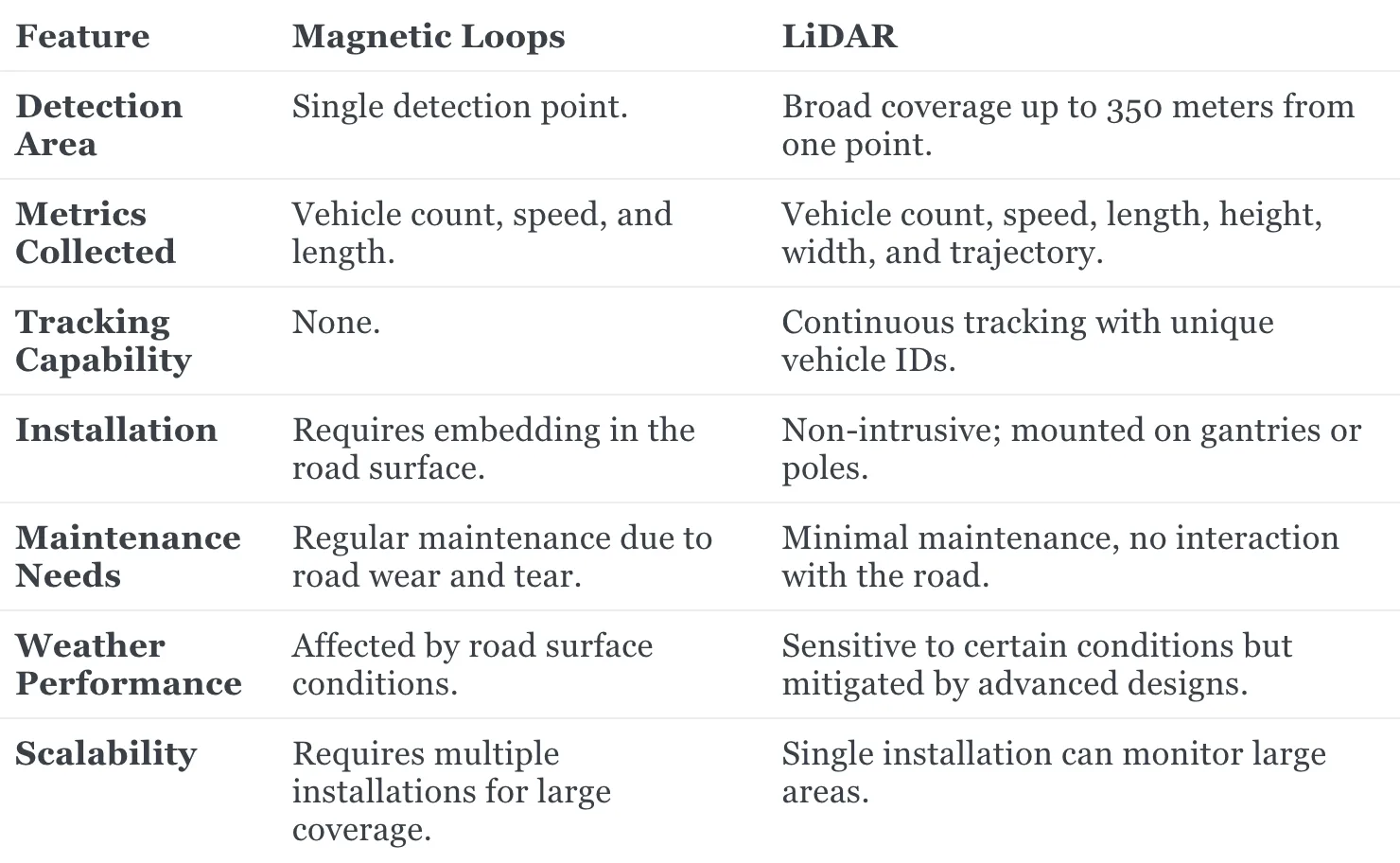
  1. Limited Scope and Coverage: Magnetic loops provide data only at specific sensor locations, making it hard to monitor larger areas. Expanding coverage requires installing multiple loops, adding complexity and cost.
  2. Installation and Maintenance Challenges: Magnetic loops are vulnerable to weather conditions and road damage and their installation disrupts traffic due to excavation. Maintenance of metal loops requires frequent repairs, which can be costly and cause delays.
  3. Limited Data and Detection Capabilities: Magnetic loops can only detect vehicle presence and length via static points. This means that they are unable to capture 3D dimensions of the vehicles through continuous tracking and they cannot detect stationary vehicles. They also miss non-metallic vehicles and pedestrians and are less accurate when vehicles change lanes.
  4. Cost and Logistical Challenges: Installation and maintenance are expensive and logistically challenging, especially when road closures are required for repairs or installation.

Road closures for repairs or installation

LiDAR: An Alternative for Traffic Detection

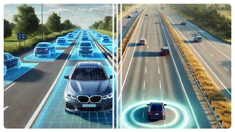
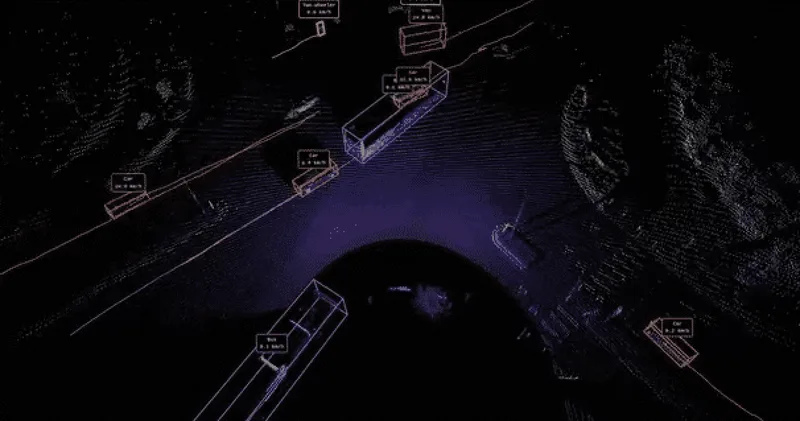
LiDAR, which stands for Light Detection and Ranging, is a remote sensing technology that uses laser beams to measure the distance between objects, creating detailed point clouds of 3D environments.
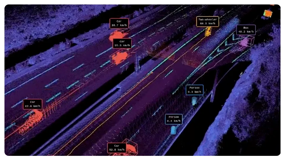
Lidar for 3d traffic monitoring by outsight

By capturing real-time 3D data, solutions using LiDAR technology can track road users’ spatial information and monitor for Key Performance Indicators (KPIs) related to vehicle traffic.

The advanced three-dimensional mapping of LiDAR offers significant advantages in tracking and classifying vehicles:

  • Superior accuracy and range: LiDAR provides high-precision, long-range detection, operating reliably in any lighting or weather condition.

Our LiDAR system achieved more than 99% detection accuracy using virtual loops, matching the capabilities of traditional magnetic loops.

  • Expanded detection capabilities: In addition to standard vehicle count, speed, and length detection, LiDAR can:
    • Detect stopped vehicles on highways
    • Classify vehicle types
    • Identify vulnerable road users like pedestrians and cyclists

Outsight’s Comprehensive ITS Solution

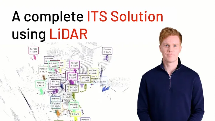
Outsight provides the easiest and most comprehensive way to use LiDAR in ITS: from Simulation to Deployment and Analytics’ Dashboard.

Read article →
  • Comprehensive Tracking: With more than 96% full tracking over a 100-meter range, LiDAR allows for a deeper understanding of vehicle behavior and traffic flow, providing insights that magnetic loops cannot offer.
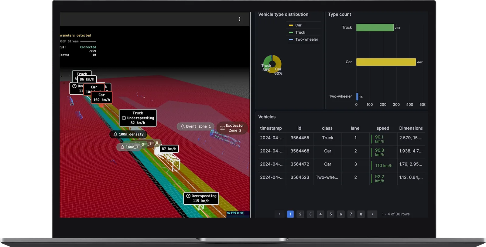
Lidar for comprehensive traffic tracking by outsight
  • Lane Independence: Unlike magnetic loops, LiDAR is not affected by vehicles changing lanes, ensuring consistent and reliable tracking in dynamic traffic conditions.

From an operational perspective, LiDAR is a more flexible solution:

  • Lower installation impact: LiDAR systems can be installed without disrupting the roadway. This reduces installation time and maintenance costs compared to magnetic loops, which require physical embedding in the road surface.

Why LiDAR Surpasses Cameras and Radar for ITS

LiDAR, Cameras, and Radar are evolving Intelligent Transportation Systems, with LiDAR leading the way.

Read article →

  • Scalability and adaptability: LiDAR systems are better suited to complex urban environments and dense highway networks, offering scalable solutions that can adapt to changing road layouts with minimal infrastructure adjustments.
Scalability and adaptability of lidar systems by outsight

While the initial cost of installing LiDAR systems is higher than that of magnetic loops, the long-term benefits make LiDAR a more cost-effective choice:

  • Reduced Maintenance: LiDAR’s non-intrusive nature eliminates road damage and minimizes maintenance costs.
  • Fewer Sensors Needed: One LiDAR setup can monitor large areas, reducing the need for multiple installations.
  • Scalability: LiDAR systems integrate seamlessly with Intelligent Transportation Systems (ITS) and can be upgraded with software updates, avoiding additional hardware costs.

Real-World Impact of LiDAR

In real-world applications, LiDAR has consistently demonstrated superior performance compared to magnetic loops:

  • Accuracy: LiDAR achieves over 99% detection accuracy, even in complex traffic conditions.
  • Weather Adaptability: Advanced LiDAR systems can mitigate environmental challenges like rain or fog, maintaining high accuracy levels.
  • Efficiency: By providing real-time, actionable insights, LiDAR enables operators to make informed decisions that enhance traffic flow and safety.

Both magnetic loops and LiDAR are proven technologies used in highway traffic monitoring today, but LiDAR is clearly the better choice for modern, intelligent traffic systems.

Its ability to provide detailed 3D data, monitor large areas, and enable real-time incident detection makes it the go-to solution for highway operators aiming to improve safety and efficiency while reducing costs over time.

Related Articles

TECHNOLOGY

Transforming ITS: LiDAR vs Camera vs Radar

LiDAR, Cameras, and Radar are evolving Intelligent Transportation Systems, with LiDAR leading the way.

APPLICATIONS

From Inductive Loops to LiDAR Solutions: The Future of City Traffic Monitoring

With Inductive Loops' limitations becoming increasingly evident, LiDAR solutions are quickly becoming the next wave for city traffic monitoring

Let's connect

Send us a Message

Drop your email and we'll get back to you as soon as possible.

Frequently Asked Questions

  • Why do magnetic loops miss stopped vehicles on highways?

    Magnetic loops detect the presence of a metallic object by measuring the disturbance it creates as it passes over the embedded coil. A stationary vehicle sitting directly above the loop saturates the field rather than disrupting it, so the system registers no event. This blind spot is operationally significant: stalled vehicles in a live lane are among the highest-risk incident types on a highway. LiDAR detects objects by their 3D geometry and position, so a parked or stalled vehicle sitting in a lane registers as clearly as a moving one. Infrastructure-based systems like Outsight's SHIFT platform exploit this property directly, using LiDAR mounted in fixed roadside or overhead positions to track vehicle presence, classify object types, and flag anomalies such as wrong-way drivers or stopped vehicles in real time, regardless of whether those objects are moving.

  • What traffic data can LiDAR collect that magnetic loops cannot?

    Beyond the vehicle count, speed, and length data that magnetic loops can approximate, LiDAR adds vehicle type classification, lane-by-lane trajectory reconstruction, detection of pedestrians and cyclists, and incident recognition such as wrong-way travel or debris in the road. The third dimension also lets operators measure vehicle height and cross-sectional shape, enabling classification of trucks, buses, motorcycles, and passenger cars without any additional sensors. Outsight applies this capability at city scale through its infrastructure-based approach: at Vision Zero intersections in Bellevue, for example, the SHIFT platform processes 3D point clouds in under 50 milliseconds to distinguish vulnerable road users from vehicles and reconstruct full movement trajectories, all without capturing faces or license plates.

  • How does road excavation for magnetic loop installation compare in cost to overhead LiDAR mounting?

    Magnetic loop installation requires cutting slots into the road surface, embedding wire coils and lead-in cables, and then resurfacing the roadway. That process typically requires lane or road closures, traffic management crews, and follow-up maintenance every time the road is resurfaced. LiDAR mounts on existing overhead gantries, poles, or bridge structures, requiring no pavement work. The installation timeline shrinks from days to hours, and there is no recurring road-damage maintenance cycle. This infrastructure-based sensor placement is central to how Outsight deploys its SHIFT platform for smart-city traffic monitoring, as demonstrated in projects such as the City of Bellevue's Vision Zero intersection program, where overhead LiDAR feeds real-time 3D data without any road modification.

  • Can LiDAR traffic sensors detect cyclists and pedestrians or just vehicles?

    LiDAR classifies objects by 3D point-cloud shape and motion, not by metallic signature. This means it distinguishes pedestrians, cyclists, and e-scooter riders from motor vehicles within the same sensor footprint. Magnetic loops physically cannot register non-metallic road users at all, and even bicycles with minimal metal content are often missed. For highways where the primary concern is vehicles this difference is marginal, but for arterial roads with shared-use zones it changes what the sensor network can deliver. Outsight applies this multi-class detection capability at city scale through its SHIFT platform, as seen in the City of Bellevue deployment where infrastructure-mounted LiDAR tracks all road user types simultaneously to support Vision Zero safety goals.

  • How does lane-changing traffic affect the accuracy of different traffic sensors?

    A magnetic loop is a fixed point in a single lane: a vehicle that straddles two loops during a lane change is double-counted or missed depending on timing, skewing vehicle counts and speed estimates. LiDAR tracks each vehicle as a continuous 3D object with a persistent ID across its full trajectory, so a lane change is recorded as a lateral movement event rather than a counting error. Outsight's infrastructure-based approach applies this principle at scale, with the SHIFT platform maintaining per-object tracking through complex multilane maneuvers in real time, using a sub-50ms pipeline. This accuracy matters most on high-speed multilane highways where weaving is frequent and counting errors from loop-based systems compound quickly into unreliable flow data.

  • Is LiDAR traffic monitoring compatible with existing ITS infrastructure like variable message signs or ramp meters?

    LiDAR traffic monitoring systems output structured data feeds (vehicle counts, speeds, classifications, incident flags) through standard ITS communication protocols, the same data types that traffic management centers already ingest from loop detectors and radar. Variable message signs, ramp meters, and signal controllers consume these feeds without modification. Outsight's SHIFT platform is designed around open integrations, meaning its 3D LiDAR perception outputs can connect directly into existing ITS stacks rather than requiring downstream infrastructure replacement. The upgrade path is typically a sensor swap paired with a software integration step, not a full overhaul of the traffic management center's existing systems.

  • How do magnetic loop traffic detectors embedded under highways actually work?

    Magnetic loops are an established traffic detection technology made of magnetic structures embedded beneath the road. The system includes wires, lead-in cables and an electronic unit that generates a current through the loop, creating a magnetic field around it. When metallic vehicles pass over the loop, they disrupt this magnetic field, and the disruption is registered as a detection. Magnetic loops have served as the standard highway traffic detection solution for decades.

  • What detection accuracy did the LiDAR traffic system reach with virtual loops versus magnetic loops?

    Outsight's LiDAR traffic monitoring system achieved more than 99% detection accuracy using virtual loops, matching the capabilities of traditional magnetic loops. In addition, LiDAR offers high-precision, long-range detection that works in any lighting or weather condition. Outsight reports that this over 99% accuracy holds even in complex traffic conditions. Beyond this detection, LiDAR adds stopped vehicle detection, vehicle classification and identification of pedestrians and cyclists.

  • How far and how completely can a LiDAR system track vehicles on a highway?

    Outsight's LiDAR system provides more than 96% full tracking over a 100-meter range. This comprehensive tracking gives operators a deeper understanding of vehicle behavior and traffic flow, providing insights that magnetic loops cannot offer. Magnetic loops only detect vehicle presence and length via static points and are less accurate when vehicles change lanes. LiDAR is not affected by lane changes, which ensures consistent and reliable tracking in dynamic traffic conditions.

  • Why do magnetic loop traffic sensors miss non-metallic vehicles on the road?

    Magnetic loops rely on metallic vehicles disrupting the magnetic field generated around a loop embedded beneath the road. Outsight lists among their drawbacks that they miss non-metallic vehicles and pedestrians, can only detect vehicle presence and length via static points, cannot detect stationary vehicles and are less accurate when vehicles change lanes. LiDAR uses laser beams to create detailed 3D point clouds and can identify vulnerable road users like pedestrians and cyclists, detect stopped vehicles and classify vehicle types.

  • How do rain and fog affect the accuracy of LiDAR-based highway traffic monitoring?

    According to Outsight, advanced LiDAR systems can mitigate environmental challenges like rain or fog and maintain high accuracy levels. LiDAR provides high-precision, long-range detection that operates reliably in any lighting or weather condition. In real-world applications it achieves over 99% detection accuracy, even in complex traffic conditions. Magnetic loops, by contrast, are described as vulnerable to weather conditions and road damage, which increases their maintenance needs.

  • Can LiDAR measure the 3D dimensions and type of vehicles that magnetic loops only detect by length?

    Yes. Magnetic loops can only detect vehicle presence and length via static points, so they cannot capture the 3D dimensions of vehicles through continuous tracking. LiDAR uses laser beams to create detailed point clouds of the 3D environment, tracking each road user's spatial information in real time. Beyond standard vehicle count, speed and length detection, this 3D mapping lets LiDAR classify vehicle types, which supports more detailed traffic KPIs.

  • Why is it hard to cover large highway areas with magnetic loop detectors?

    Magnetic loops provide data only at the specific locations where they are embedded, which makes monitoring larger areas difficult. Expanding coverage means installing multiple loops, adding complexity and cost, and installation disrupts traffic due to excavation. Outsight notes that one LiDAR setup can monitor large areas, reducing the need for multiple installations, and that its LiDAR system provides more than 96% full tracking over a 100-meter range. LiDAR can also be installed without disrupting the roadway.

  • Can a LiDAR traffic monitoring system gain new capabilities through software updates?

    Yes. Outsight explains that LiDAR systems integrate seamlessly with Intelligent Transportation Systems (ITS) and can be upgraded with software updates, which avoids additional hardware costs. This scalability is one of the reasons Outsight gives for LiDAR being a more cost-effective long-term choice than magnetic loops, alongside reduced maintenance and the need for fewer sensors. The initial cost of installing LiDAR systems is higher than that of magnetic loops, but the long-term benefits make LiDAR more cost-effective.

  • How does LiDAR traffic monitoring adapt to dense urban networks and changing road layouts?

    LiDAR systems are better suited to complex urban environments and dense highway networks, according to Outsight. They offer scalable solutions that can adapt to changing road layouts with minimal infrastructure adjustments. Since they are installed without disrupting the roadway, operators avoid the excavation and road closures that magnetic loops require. Lane independence also keeps tracking consistent and reliable when traffic conditions are dynamic.

  • What maintenance problems do magnetic loops create for highway operators?

    Magnetic loops are vulnerable to weather conditions and road damage. Their maintenance requires frequent repairs, which can be costly and cause delays, and both installation and repairs often need road closures because the loops are physically embedded in the road surface. LiDAR is installed without disrupting the roadway, and Outsight notes that its non-intrusive nature eliminates road damage and minimizes maintenance over the life of the system.

  • How do smart highways detect stopped vehicles and incidents?

    Smart highways use roadside sensors that continuously track every vehicle so that a stopped vehicle can be detected quickly and reported to traffic control. LiDAR is well suited because it measures position and speed precisely, works day and night and in varied weather, and covers long stretches per sensor. Its data can also feed counts, classification and speed statistics. Outsight's LiDAR software supports these smart highway and ITS applications.