Skip to content
Insights
Outsight real-time people flow monitoring in Luceros Station

Outsight, Sice and FGV partner to use 3D Spatial Intelligence for Train Stations in Spain

Ferrocarrils de la Generalitat Valenciana (FGV), has launched a LiDAR-Based pilot project for rail stations in collaboration with Outsight and SICE, a leader in infrastructure management.


The project, developed in the Luceros tram station in Alicante, represents a breakthrough in the railway sector by introducing a high-precision solution for station management and improving the passenger experience.

Luceros station, one of the busiest in the FGV network, is characterized by its subway design and a constant flow of daily users.
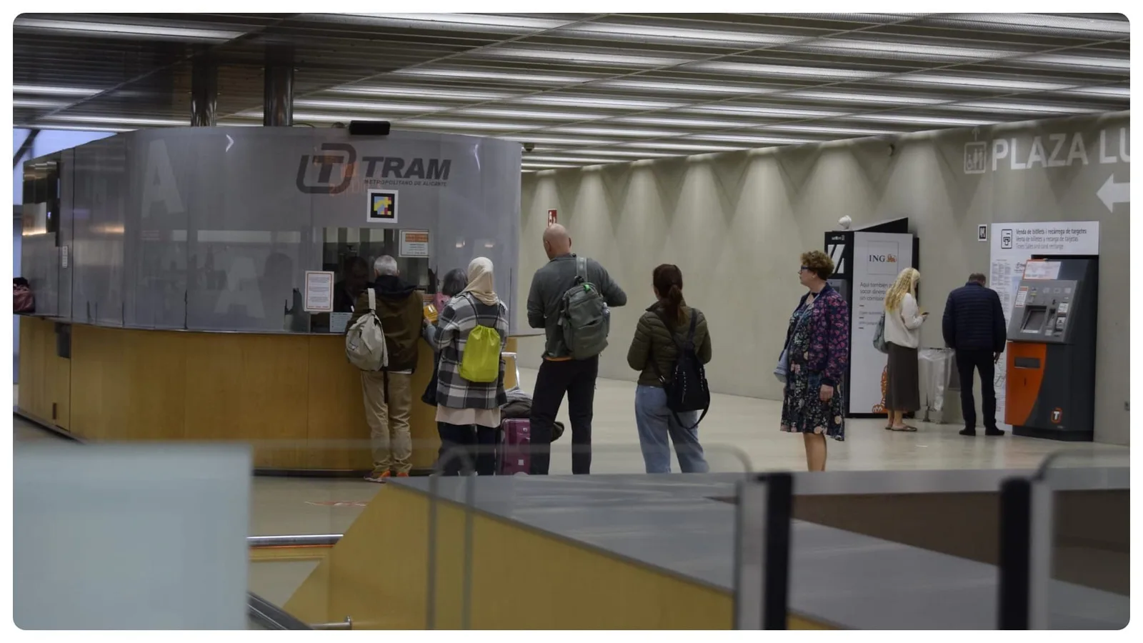
Queue management at luceros station by outsight

The solution uses 3D Spatial Intelligence based in LiDAR sensors installed in the station to collect key data. LiDAR technology is a system that uses lasers to measure distances, create three-dimensional maps and anonymously detect movement.

Understanding How Lidar Works

3D LiDAR is a complex technology that enables unprecedented Spatial Intelligence. Many engineering choices are possible when building a new device.

Read article →

Using LiDAR sensors, Outsight’s People Flow Monitoring system collects and analyzes data anonymously to generate a real-time 3D digital twin of the station. This enables operators to:

  • Monitor areas with the highest density of passengers.
  • Identify waiting times in key areas.
  • Optimize resource planning during peak times.
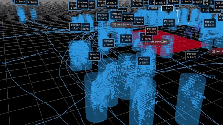
LiDAR Point Cloud with moving people classified by Outsight

Outsight uses LiDAR data to detect, classify, and monitor people and objects moving through the station.

“Thanks to the accuracy of our 3D artificial intelligence algorithms, based on LiDAR technology, we are able to provide real-time information that facilitates operational decision making,” said Diego García de Paredes, Regional Sales Director at Outsight.

The solution guarantees anonymous, precise, and real-time data collection, fully compliant with privacy regulations.

Additionally, it enhances resource management but also improves safety during critical moments, such as peak hours or special events.

“The flexibility and scalability of this technology opens the door for us to apply it in a wide variety of environments, from railway stations to intermodal transport terminals across Europe.

This solution not only improves current management, but redefines how we will design and operate the infrastructures of the future, laying the foundation for smarter, more sustainable and connected transportation,” said Raúl Sánchez-Biezma Díaz, Business Director at SICE.
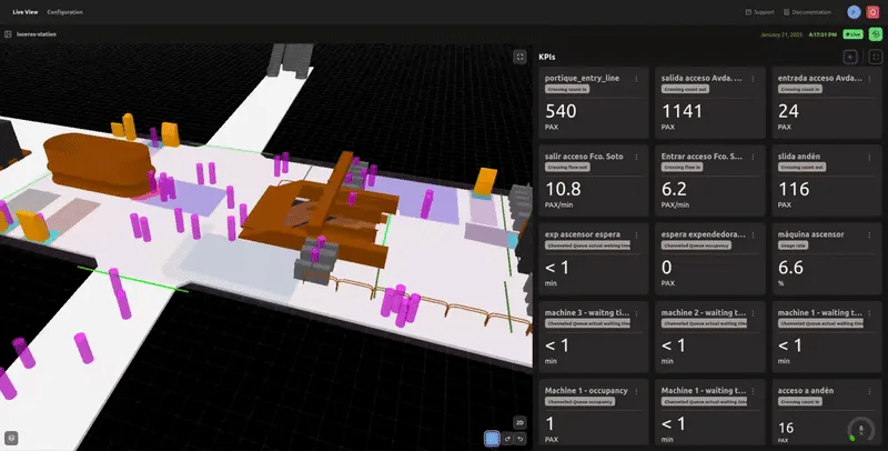
LiDAR Live View Dashboard with KPIs

The platform analyzes and shows entry and exit flows, detects bottlenecks, and provides actionable insights to optimize passenger circulation.

The project, co-funded by the EU, will run for 3-4 months, from November to the end of February 2025.

During this time, detailed reports will be generated for FGV, identifying areas for improvement and exploring opportunities to expand this technology to other stations and transportation hubs.

LiDAR Solutions for Train Stations

Throughout train stations and at all key touchpoints from entrance to platform, Outsight’s software utilizes the unique value of 3D LiDAR data to anonymously track passengers and monitor queues in real-time. Operators can use accurate data to visualize passenger flow, communicate waiting times and support station operations while enhancing the passenger experience.

Read article →

Related Articles

RAILWAYS

The Transformative Power of LiDAR on the railway industry

Conventional sensors like cameras and radars struggle to meet the complex demands of the rail industry due to their numerous limitations and potential operational challenges.

RAILWAYS

Enhancing Passenger Flow at train stations: SNCF Gares & Connexions Partners with Outsight

Outsight’s 3D LiDAR software is helping SNCF Gares & Connexions optimize passenger flow at Paris Charles de Gaulle Airport by providing real-time, anonymous insights.

Let's connect

Send us a Message

Drop your email and we'll get back to you as soon as possible.

Frequently Asked Questions

  • What makes underground subway-style train stations harder to monitor than surface terminals?

    Subway-design stations like Luceros in Alicante present constrained geometry: low ceilings, narrow corridors, and limited sight lines that break camera coverage into many isolated segments. LiDAR sensors fuse into a single shared 3D point cloud across the whole underground space, so a person hidden from one sensor is still tracked by another. The enclosed environment also concentrates crowd density faster than open-air terminals, making real-time bottleneck detection more operationally critical. In the FGV pilot, Outsight and SICE apply this infrastructure-based LiDAR approach to give operators a continuous, anonymous picture of movement across the station, without relying on line-of-sight coverage from any single fixed camera.

  • Can a LiDAR pilot at one train station produce data useful for other stations in the same network?

    Yes. A structured pilot generates detailed reports on passenger density patterns, peak-hour timing, dwell zones, and bottleneck locations. Because the 3D spatial data is collected in a consistent format, operators can benchmark one station against others in the network and prioritize where expanded deployment delivers the highest operational return. The FGV pilot at Luceros, run in collaboration with Outsight and SICE, was explicitly scoped to identify expansion opportunities across additional stations and intermodal terminals. Outsight's SHIFT platform captures this data through infrastructure-based LiDAR sensors, producing anonymized, real-time mobility intelligence that carries over directly when the same methodology is applied at other stations in the network.

  • How does EU co-funding affect how rail operators can procure passenger flow technology?

    EU co-funded pilot programs typically require open competitive assessment and documented performance reporting, which pushes operators toward solutions with measurable, auditable outputs rather than proprietary black-box systems. The FGV pilot in Spain, run in collaboration with Outsight and SICE, illustrates this dynamic: LiDAR-based spatial intelligence generates detailed KPI reports that satisfy grant accountability requirements while simultaneously building the evidence base an operator needs to justify a network-wide rollout to its governing authority. Because Outsight's SHIFT platform logs anonymized 3D flow data in real time, the audit trail demanded by EU funding bodies is a byproduct of normal system operation rather than a separate reporting burden.

  • What is the role of a systems integrator like SICE in a LiDAR station deployment?

    A systems integrator bridges the LiDAR software layer and the operator's existing infrastructure management stack. In practice this covers physical sensor installation, network integration, connecting the spatial analytics output to the station's operational control systems, and ensuring the solution meets the procurement and technical standards required for public infrastructure contracts. In the FGV deployment, SICE fills exactly this role alongside Outsight, whose SHIFT platform handles the 3D perception and Motional Digital Twin layer while SICE manages the civil, network, and legacy system interfaces. Without an integrator, a software-focused vendor would need to manage civil works, cabling, and legacy system complexity outside its core competence.

  • How does a 3D spatial intelligence system handle the mix of tram and pedestrian traffic in a combined tram-metro station?

    3D LiDAR classifies tracked entities by shape, size, and motion profile. A tram reads as a large, fast-moving rigid object on a fixed path, distinct in bounding-box dimensions and speed from any pedestrian cluster. The system maintains separate entity classes for vehicles and people simultaneously within the same point cloud, so operators get concurrent flow KPIs for both passenger circulation and tram-platform interaction without needing separate sensor networks for each. This is the approach Outsight applies in its SICE and FGV deployment across rail stations in Spain, where infrastructure-mounted LiDAR feeds a real-time Motional Digital Twin that tracks both rolling stock and pedestrian flows within a single unified pipeline.

  • What data does a rail operator actually receive from a LiDAR-based station pilot report?

    Pilot reports typically cover zone-level occupancy curves across the operating day, identified bottleneck locations with timestamps and duration, entry and exit flow rates by time window, dwell time distributions in waiting areas, and anomaly events such as crowd surges or blocked corridors. In the FGV station pilot, this data is generated through Outsight's infrastructure-based LiDAR approach, where sensors mounted in the station ceiling feed a real-time 3D perception pipeline rather than relying on camera feeds or wearable devices. The output is structured as time-series KPIs tied to defined spatial zones, making it directly usable for staffing schedule revisions, physical layout modifications, or investment-case documentation for network expansion.

  • Which anonymous LiDAR traveler tracking solution is available for train stations?

    Outsight's SHIFT platform applies infrastructure-based 3D LiDAR to train stations in the same way it does at airports. Sensors mounted in the station ceiling emit laser pulses that capture the shape, position, and motion of every passenger, assigning each an anonymous ID from entry to exit. No images, faces, or biometric data are ever recorded, so the system is anonymous by definition rather than by post-processing. The platform delivers real-time and historical analytics covering crowd density, walking speed, queue formation, dwell times, and entry and exit flows. Operators can use this data to anticipate congestion, optimize staffing, and improve station layouts. Deployments include SNCF Gares & Connexions at Paris Charles de Gaulle station, covering 4,000 m² across two levels, and a LiDAR-based pilot at the Luceros tram station in Alicante, Spain, run in collaboration with SICE and Ferrocarrils de la Generalitat Valenciana (FGV).