Skip to content
Insights
3D perception adds a new capability to perceive the reality without occlusions

Understanding Shadowless 3D Perception

Unlike cameras, which perceive reality from a single point of view, 3D native data from LiDAR opens up new possibilities.


A significant advantage of 3D LiDAR perception over other optical sensors like cameras or people counting solutions is its ability to collect environmental information without any obstructions (i.e., Shadowless perception).

To better understand this concept, let’s look at a typical scene in a crowded environment with four individuals.
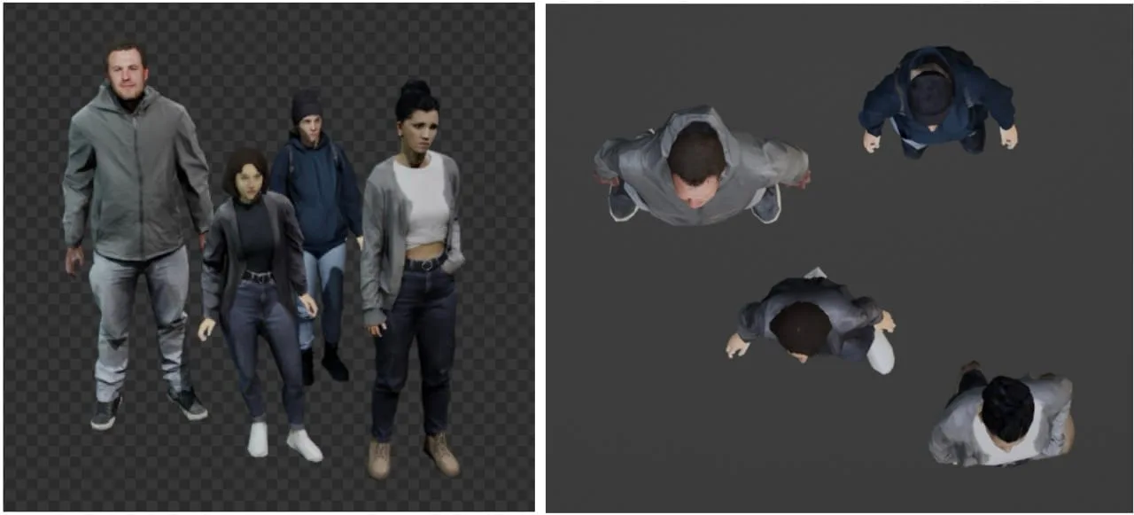
The scene we want to capture, a typical situation in crowded environments. The right part of the image shows a top-view version to better depict the position of each person

The scene we want to capture, a typical situation in crowded environments. The right part of the image shows a top-view version to better depict the position of each person.

These images show what different cameras in various positions would see from the scene:
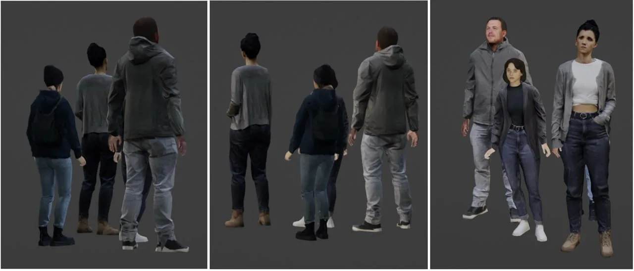
Depending on the point of view of each camera, some persons are occluded by others

Depending on the point of view of each camera, some persons are occluded by others

As seen in the image, different people are occluded by others, depending on each camera position. Here, the adults cast a “shadow” that hides the child.

Under these conditions, even the most advanced computer vision algorithms for people counting or object tracking will struggle to detect the hidden individuals and consistently follow them over time.

Now, let’s view the same scene through a LiDAR sensor. With 3D vision, LiDAR accurately determines the position and size of each person.
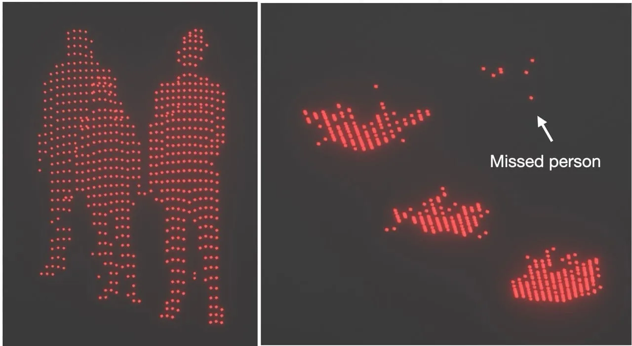
Lidar is not different in this aspect, each individual sensor can only see part of the scene

Lidar is not different in this aspect, each individual sensor can only see part of the scene

However, just like with a camera, the LiDAR’s laser pulses must hit each object to detect their presence. If an object is hidden by another one it won’t be detected.

Different LiDAR positions will miss different objects:
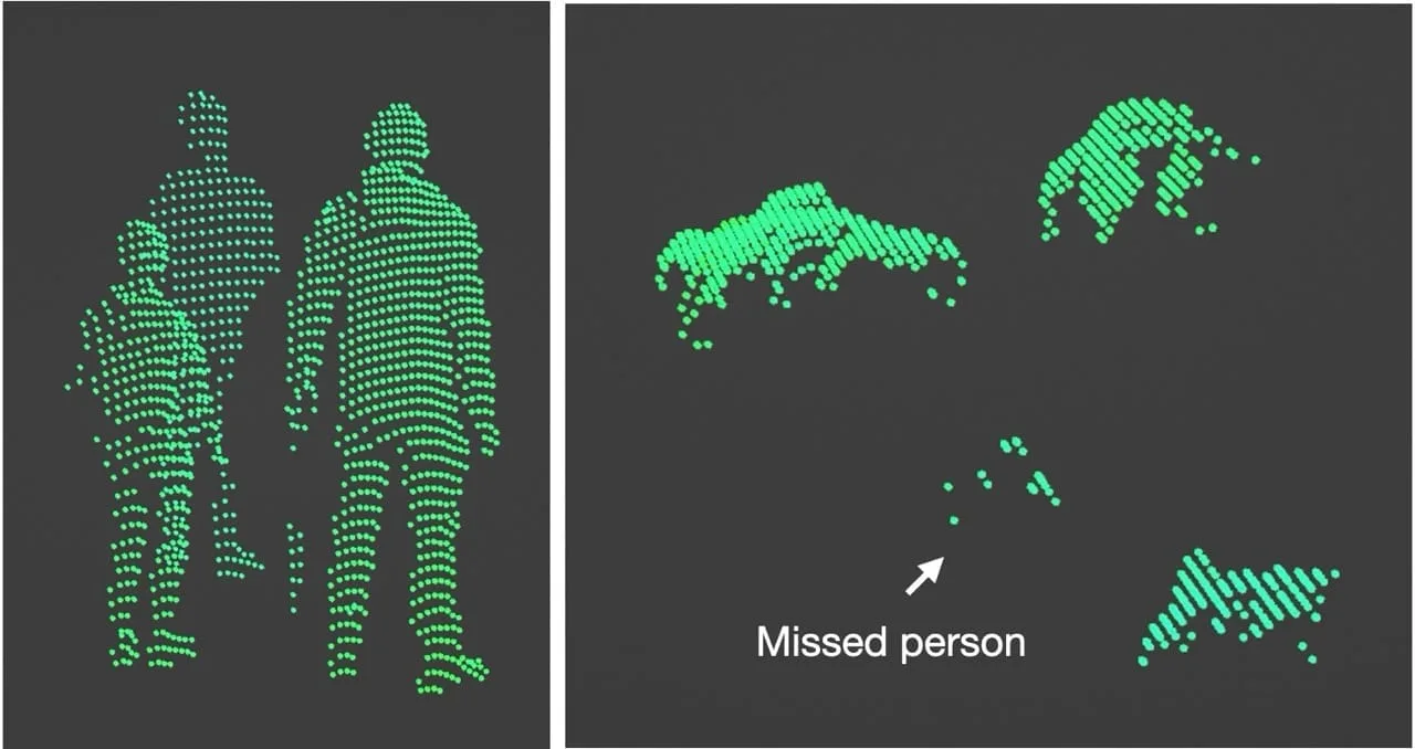
Different points of view of LiDAR create different blind zones

Different points of view of LiDAR create different blind zones

So, if LiDAR has the same limitations as cameras in these situations, why discuss LiDAR at all?

The answer is that 3D perception changes everything.

Because laser pulses are natively positioned in a 3D coordinate system (unlike camera images), advanced fusion software like Outsight’s Spatial Intelligence Platform can seamlessly merge the data from each sensor into a global 3D point cloud:
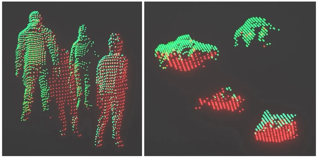
In this image we show the merge of two different sensors that create a unique point-cloud

In this image we show the merge of two different sensors that create a unique point-cloud

With this approach, each LiDAR sensor does not perceive reality independently: each sensor’s perception contributes to a shared pool of information.

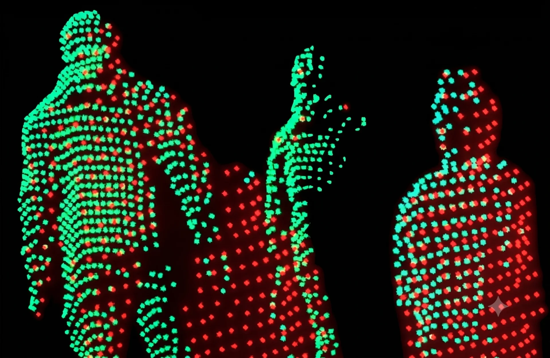
As a result, an advanced Spatial AI solution like Outsight’s Spatial Intelligence Platform will leverage a unique kind of LiDAR sensor data, the equivalent of a virtual 3D sensor without occlusions, offering shadowless perception:
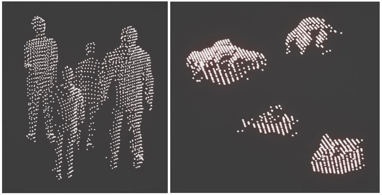
The final result is a 3D point-cloud that is independent on which specific sensor fed the common pool of data

The final result is a 3D point-cloud that is independent on which specific sensor fed the common pool of data

As shown in the image, 1 +1 = 3. The resulting perception is much better than the separate perception of the first sensor and the second one, thanks to spatial consistency.

The challenges of using Shadowless Perception

Calibration

To perfectly merge the data from different LiDAR sensors, it’s important to use appropriate software, tools and methods.

If the LiDARs are not correctly aligned on the same 3D coordinate system, they can easily create phantom points: the same points seen by different LiDARs can be interpreted as belonging to different objects in the physical scene.

This alignment process, known as calibration, becomes exponentially more challenging as the number of sensors increases.

Calibrating a few LiDARs is much simpler than calibrating hundreds, a task our solution regularly handle for our customers in airports, train stations, and factories, to anonymously follow the movement of thousands of people in crowded environments, in real-time.

The challenge of Synchronization

When merging multiple point clouds from different LiDARs, a significant challenge is the lack of precise temporal synchronization.

Unlike cameras that capture an entire scene instantly with a flash, LiDARs scan the environment over a period (typically 100ms) to create a full 3D view.

Understanding How Lidar Works

3D LiDAR is a complex technology that enables unprecedented Spatial Intelligence. Many engineering choices are possible when building a new device.

Read article →

This means they can’t observe all objects simultaneously. For example, a person scanned by one LiDAR at time t will be scanned by another LiDAR at time t + t1, during which the person may have moved and changed posture. This results in a blurred and imprecise fusion of data.

The challenge of creating accurate Analytics

Any Analytics software or Company that doesn’t provide an appropriate Outsight’s Spatial Intelligence Platform able to Merge, Calibrate and Synchronise many LiDAR sensors precisely will struggle to provide correct metrics.

The benefits of occlusion-free perception

The advantages of shadowless perception translates in several concrete benefits:

  • Accurate Data Fusion: Merging data from multiple LiDAR sensors into a unified 3D point cloud ensures comprehensive scene understanding without phantom points.
  • Improved Analytics: Shadowless perception eliminates occlusions, allowing for accurate detection of all objects in a scene, even in crowded environments. This accuracy is essential for high-quality data analytics.
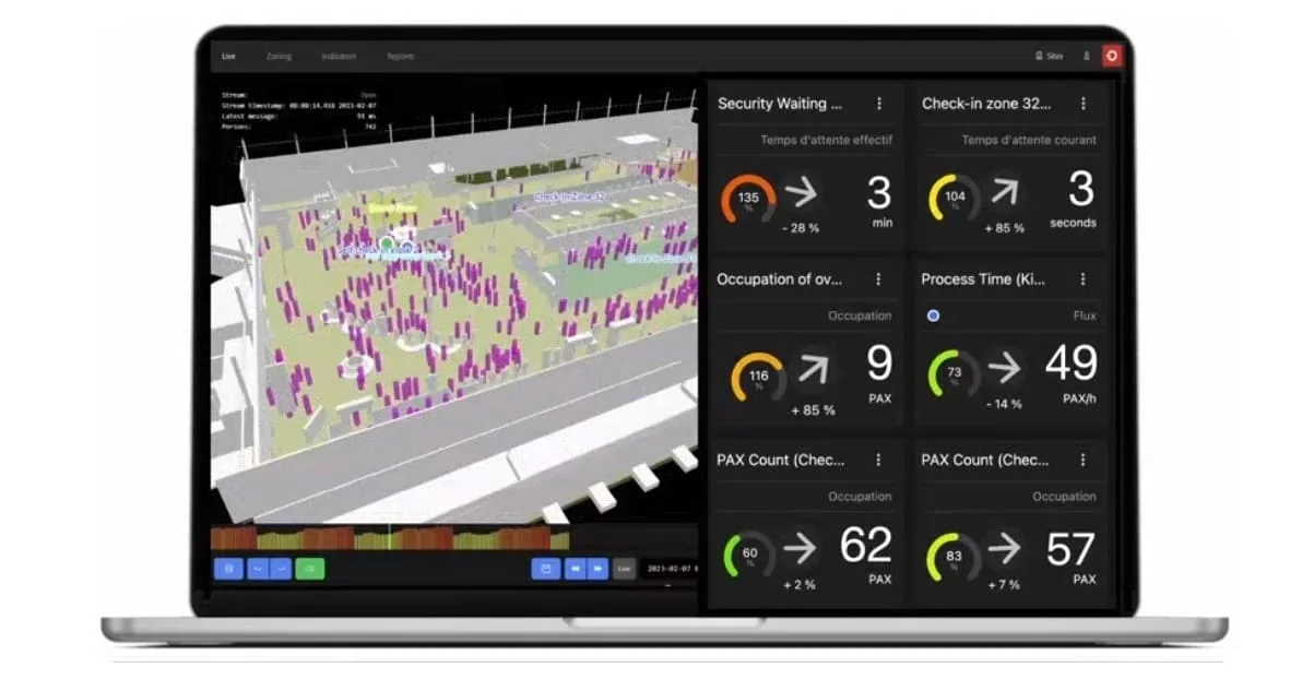
Shift Analytics from Outsight - Spatial AI Platform

Shift Analytics from Outsight - Spatial AI Platform

  • Enhanced Tracking: Continuous and unobstructed tracking of moving objects becomes possible, improving the reliability of tracking results.
  • Scalability: Advanced calibration and synchronization methods enable the integration of numerous sensors, making it scalable for large applications like airports, sports venues, and factories.
  • Less Sensors per Square Meter: Without a good fusion solution, more sensors per square meter are needed. Shadowless perception reduces the number of required sensors.
  • Robustness: Each sensor feeds into a common pool of information, so a hardware malfunction of a single device decreases only the number of available points but does not become a single point of failure.
  • Optimized Use of Different LiDAR Technologies: Different LiDAR manufacturers and models create different scanning patterns. A shadowless perception solution like Outsight’s leverages the best of each technology, creating a full 3D virtual sensor that surpasses the capabilities of each device separately.
Related Articles

TECHNOLOGY

An in-depth comparison of LiDAR, Cameras, and Radars' technology

This article explores the capabilities and limitations of each type of sensor, to provide a clear understanding of why LiDAR has emerged as a strong contender in computer vision tech race.

TECHNOLOGY

What is Lidar?

3D LiDAR, with the right software, delivers precise Spatial Intelligence for industries like smart infrastructure and automation, enabling accurate mapping while protecting privacy.

Let's connect

Send us a Message

Drop your email and we'll get back to you as soon as possible.

Frequently Asked Questions

  • What happens to tracking accuracy when one LiDAR sensor fails in a multi-sensor deployment?

    Because all sensors feed a shared 3D point cloud rather than operating as isolated instruments, a single hardware failure reduces the density of available points in that coverage zone but does not create a complete blind spot. Other sensors covering the same area continue contributing data. This architectural redundancy is a direct consequence of the fused-pool design: no individual device is a single point of failure for the scene as a whole. Outsight's Motional Digital Twin is built on this principle, ingesting point clouds from multiple LiDAR units across an infrastructure so that the real-time 3D replica of pedestrian and vehicle movement remains continuous even when one sensor goes offline.

  • Why does multi-sensor LiDAR fusion get harder as the number of sensors grows?

    Calibration complexity scales faster than linearly with sensor count. Aligning two sensors to a shared 3D coordinate system is straightforward; aligning dozens or hundreds requires each sensor's position and orientation to be precisely referenced to every other, and any small error compounds across the network. Miscalibration produces phantom points: the same physical surface appears as two separate objects. Synchronization adds a second dimension of difficulty, since each LiDAR scans across a roughly 100-millisecond window, meaning a person moves measurably between one sensor's scan and another's. Outsight addresses this at infrastructure scale through its SHIFT platform, which manages multi-vendor LiDAR networks spanning Hesai, RoboSense, Ouster, and other hardware within a sub-50ms end-to-end pipeline, keeping calibration and temporal alignment consistent across deployments as large as Dallas Fort Worth International Airport.

  • Does fusing LiDAR point clouds from different manufacturers create compatibility problems?

    Different LiDAR manufacturers use different scanning patterns, beam counts, and rotation rates, which means raw point cloud formats and densities vary considerably across hardware. Fusion software must normalize these differences before merging. When calibration and synchronization are handled correctly, the varying scanning geometries become an advantage: each model's coverage pattern fills gaps left by others, and the combined virtual sensor can exceed the angular resolution of any single device in the network. Outsight's SHIFT platform is built around this reality, supporting multi-vendor compatibility across hardware from Hesai, RoboSense, Ouster, Velodyne, and Seyond specifically to enable mixed-fleet deployments, feeding a unified Motional Digital Twin regardless of which sensor manufacturers are present on site.

  • Can shadowless LiDAR perception track a child obscured by adults in a dense crowd?

    A single LiDAR sensor placed at adult head height will miss a child standing directly behind an adult, the same occlusion problem cameras face. With sensors positioned at multiple angles and heights feeding a unified 3D point cloud, the child's geometry is captured by at least one sensor in the network even when occluded from others. This is the principle behind infrastructure-based deployments like those Outsight operates at major transit hubs, where sensor arrays are engineered for volumetric coverage rather than simple floor-area coverage. The merged point cloud then presents the child as a continuously tracked entity within the Motional Digital Twin. Coverage overlap across angles, not just floor area, determines whether low-height or partially occluded subjects are reliably detected, which is why sensor placement planning is treated as a first-order design decision.

  • How does sensor placement geometry affect occlusion in a large indoor venue?

    The optimal placement minimizes the angular overlap between any two sensors' blind zones. When sensors share the same blind zone, adding a second sensor does not improve occlusion coverage. Placing sensors at varied heights and offset horizontal angles ensures that a person hidden from one sensor falls within the line of sight of at least one other. In practice, ceiling-mounted sensors at different heights along a concourse outperform an equal number of sensors mounted at identical heights, because the vertical offset creates different elevation angles to low obstructions. This geometry principle underpins Outsight's infrastructure-based deployment approach, where sensors are positioned across the built environment rather than on moving entities, allowing the Motional Digital Twin to maintain continuous, gap-free tracking even in dense venues like airport concourses and train stations.

  • Is shadowless 3D perception the same as sensor fusion used in autonomous vehicles?

    The underlying math, registering multiple point clouds into one coordinate frame, is related, but the operational context differs in important ways. Autonomous-vehicle sensor fusion runs on a moving platform with sensors that shift position continuously, requiring real-time ego-motion compensation. Infrastructure-based shadowless perception uses fixed sensors whose calibration, once established, remains stable until physically disturbed. Fixed-position calibration can be validated against a known static environment, making the fusion more deterministic and the resulting tracking more consistent across long deployments. Outsight's approach, formalized as Infrastructure-based Physical AI, builds on exactly this principle: LiDAR sensors are deployed in the infrastructure rather than on any moving entity, allowing the SHIFT platform to maintain a stable, real-time 3D replica of a space without the ego-motion complexity that challenges vehicle-mounted systems.