Table of Contents
- Introduction
- How 3D LiDAR Works
- The History and Evolution of LiDAR
- LiDAR vs. Cameras: Key Differences in Perception Technologies
- Applications and Advantages of LiDAR Technology
- Integration Challenges and Industry Standards
- Conclusion: The Future of Spatial Intelligence with LiDAR
Introduction
LiDAR (Light Detection and Ranging) has become a foundational technology for three-dimensional perception across numerous industries.
By emitting laser pulses to measure distances, it enables the creation of highly accurate spatial maps, helping computers, robots, vehicles, and infrastructure systems understand their environments in real time.
Smart Infrastructures like Airports around the world use LiDAR to monitor passenger movement efficiently regardless of lighting conditions or crowd density.
The growing significance of this technology is evident in its adoption for people flow monitoring at transportation hubs, vehicle automation systems on roads, robotics in warehouses, industrial safety protocols on factory floors, and environmental assessment projects.
How does Lidar work? (in detail)
3D LiDAR is a complex technology that enables unprecedented Spatial Intelligence. Many engineering choices are possible when building a new device.
Read article →

As demand rises for reliable spatial data that respects privacy while delivering precision at scale, 3D LiDAR stands out as a trusted solution.
How 3D LiDAR Works
At its core, a typical LiDAR system operates by transmitting rapid bursts of laser light from a sensor or transmitter toward surrounding objects.
When these pulses strike surfaces, whether walls or moving vehicles, they reflect back to the device’s receiver. By measuring the time each pulse takes to return (using the constant speed of light), the system calculates precise distances.
A single modern sensor can capture up to 20 frames per second, each frame containing millions of points representing real-world objects’ positions in three dimensions.
These measurements are aggregated into what’s known as a “point cloud”, a dense collection of data points that together form an accurate digital representation of physical spaces.
Multiple point clouds captured over time allow software platforms to build comprehensive dynamic maps suitable for navigation or analysis.
Introducing the first multi-vendor 3D LiDAR Simulator
Outsight has developed a LiDAR simulator for any use case and application, from airports to mobile robotics, smart cities and industrial applications.
Read article →
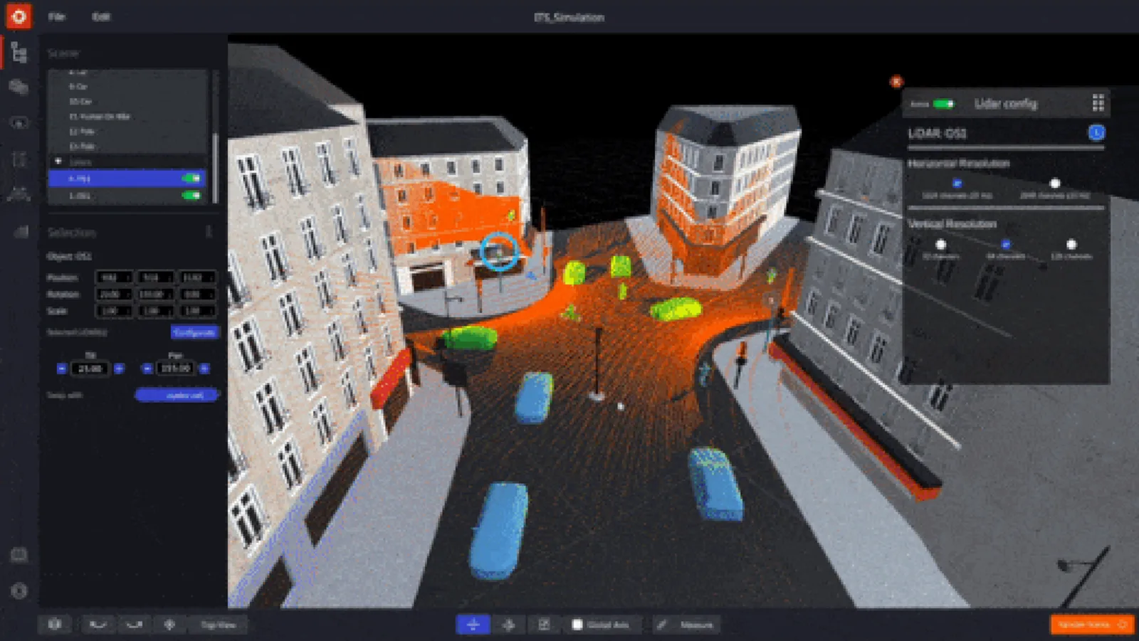
Depending on requirements, sensors may be installed on stationary mounts (for fixed infrastructure), mobile robots or vehicles (for autonomous navigation), drones (for aerial mapping), or even satellites orbiting Earth.
The History and Evolution of LiDAR
LiDAR’s origins trace back to research efforts from the late 1950s when scientists explored optical radar techniques using lasers instead of radio waves. Its first major public application was during NASA’s Apollo 15 mission in 1971; astronauts used early versions onboard lunar modules for detailed surface mapping.
During Apollo missions in the early ’70s, astronauts relied on primitive airborne laser altimeters, the direct ancestors to today’s high-resolution terrestrial scanners, for lunar cartography tasks.
Throughout subsequent decades, from terrain modeling projects during the ’90s through forestry management initiatives, the technology matured rapidly thanks to advances in computing power and miniaturization.
In recent years it has entered consumer markets via smartphones equipped with compact sensors capable not only of augmented reality but also interior design planning based on room scans, a testament to how far this once-specialized tool has come.
Not All LiDAR Sensors Are Equal: Key Differences Explained
This article explores LiDAR differences and why customers use multiple vendors to meet their needs.
Read article →
LiDAR vs. Cameras: Key Differences in Perception Technologies
While both cameras and LiDAR are essential tools within modern perception systems, including those found inside autonomous vehicles, they serve distinct roles:
Cameras excel at capturing rich visual details such as color gradients or object textures under ambient light conditions; they help answer questions like “Is this object a person?”
However:
- Their performance drops significantly under poor lighting.
- They often require complex algorithms, and sometimes personal data, to classify individuals accurately, as well as energy-intensive GPUs.
- Privacy concerns arise due to image-based identification capabilities.
In contrast:
- LiDAR specializes exclusively in measuring distance with unmatched accuracy regardless of lighting.
- It produces anonymized geometric data rather than photographs, supporting privacy by design.
- Its output is ideal for applications where knowing exact shapes/positions matters more than recognizing faces or colors.
Unlike video feeds from cameras, which can inadvertently capture sensitive information, LiDAR provides actionable Spatial Intelligence without collecting personally identifiable images.
Anonymous vs. Anonymized : Learn the Difference
Understanding Anonymity in Sensor Data: discover the inherent privacy characteristics of each type of Sensor data and the potential risks associated with anonymizing sensitive information
Read article →

Applications and Advantages of LiDAR Technology
Thanks largely to its reliability across diverse environments, and robust privacy protections, LiDAR now plays an indispensable role throughout sectors such as smart infrastructure management, automated transport networks, industrial robotics, environmental science, urban planning, security operations, logistics optimization, asset tracking, even consumer electronics integration.
Organizations benefit from features including:
- Consistent operation day/night, even amid glare or darkness
- High-density measurement capability over large areas
- Real-time feedback supporting rapid decision-making processes
- Enhanced safety through precise detection/avoidance mechanisms
- Compliance-friendly solutions that minimize exposure risk related to personal data handling
For example:
Major transportation hubs deploy our Spatial Intelligence solutions powered by advanced LiDAR analytics, to improve passenger flow efficiency while maintaining strict adherence to global privacy standards.
As leaders recognized by industry analysts worldwide we continue helping customers unlock new value streams using these technologies every day.
Gartner® Highlights Outsight as Digital Twin leader
Recognized for pioneering real-time digitalization of dynamic environments, Outsight sets itself apart by focusing on the live monitoring of people and vehicle flows.
Read article →

Integration Challenges and Industry Standards
Despite clear advantages offered by LiDAR devices compared with legacy alternatives, notably superior accuracy and reliability, a few challenges remain when integrating them into existing workflows.
Many manufacturers employ proprietary hardware interfaces and formats which complicate interoperability between different brands and models.
Software platforms must process vast volumes of raw point cloud data efficiently.
Deployment often requires specialized expertise spanning both hardware installation and calibration plus algorithm development and tuning.
These factors have slowed universal adoption, but ongoing standardization efforts aim toward greater compatibility going forward.
According to recent surveys among system integrators working with multi-vendor fleets: lack of standardized APIs remains one primary barrier cited during project rollouts.
Our commitment includes active participation within international working groups focused specifically upon open standards development, to help ensure smoother deployments industry-wide.
Outsight enters the Intel®Partner Alliance as a Gold Member
We’re proud to announce our membership in the Intel® Partner Alliance as a Gold Member. Together, we are set to deliver unprecedented solutions in the emerging field of Physical AI.
Read article →

Conclusion: The Future of Spatial Intelligence with LiDAR
From its beginnings supporting space exploration missions through current-day deployment inside airports, cities, factories, and homes alike, LiDAR continues shaping how organizations perceive and manage their surroundings safely and effectively.
While technical hurdles persist around harmonizing disparate ecosystems, the proven ability delivered by advanced sensors ensures ongoing relevance well beyond today.
As adoption accelerates globally across public and private sectors alike, the combination of high-fidelity measurement plus strong inherent privacy protections makes LiDAR central to future-ready Spatial Intelligence strategies everywhere.