Skip to content
Insights
The myths about lidar technology

The 5 Misconceptions About LiDAR Technology

LiDAR technology is significantly enhancing various sectors with its valuable insights. Unfortunately, there are several misconceptions surrounding this innovative tool.


LiDAR, which stands for Light Detection and Ranging, is a remote sensing method, and has recently gained much attention as an innovative tool.

This technology has changed how we collect and analyze data, providing accurate and precise measurements for multiple applications.

Despite its growing popularity, there has also been a spread of misleading information and misconceptions about LiDAR technology.

Let’s understand LiDAR technology better and use it to its full potential.

1. The Complexity of LiDAR Technology

There is a belief that this technology can be difficult to understand due to its complexity.

The technology is complicated, but its basic principles are easy to understand.

LiDAR measures distance using light. It emits a laser pulse that bounces off an object and returns to the sensor. This process resembles how animals like bats and dolphins use sound to find prey.

How does lidar work? by using laser light emitted pulses that accurately measures the distance between the lidar sensor and object

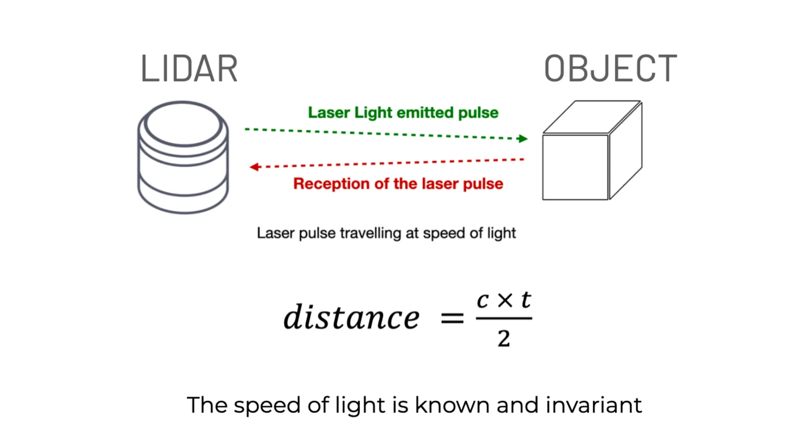
A single laser pulse is used to measure the distance between the sensor and the object. Typical LiDARs emit millions of these pulses per second.

Understanding the basics of 3D LiDAR Technology

Light Detection and Ranging, also known as LiDAR, is a technology for remote sensing that is used to measure distances in an environment.

Read article →

2. Still New and Developing

Industries used LiDAR since the 1960s initially for high-resolution short-range detection in situations where radar was not capable. However, there is a common misunderstanding that LiDAR is still developing with no real-world uses.

In the 1970s, experiments started with the idea of measuring the distance to the Earth’s surface. During the Apollo 15 mission, the astronauts used it to map the moon’s surface. During the 1990s and 2000s, the sensors mapped terrain and created digital elevation models.

In modern times, LiDAR technology has proven useful in multiple industries.

While innovations are still in development, the technology is already widely adopted, with current performance exceeding the needs of many use cases.

For example, Outsight has deployed solutions in many industries, and deployed challenging projects with hundreds of LiDAR devices on the same premises, all working in real-time.

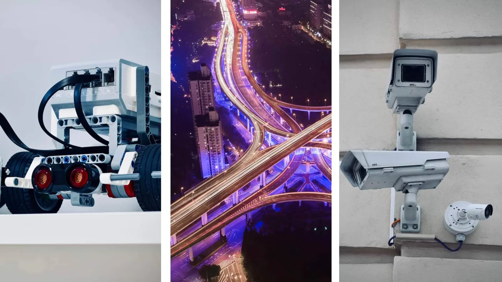
3. Only Used in Autonomous Vehicles

LiDAR technology is often associated only with self-driving cars.

However, there are many uses for it in different industries.

The benefits of the technology are not solely for automotive but for archaeology, PFM (People Flow Monitoring), ITS (Intelligent Transportation Systems), public safety, and many more.

Lidar can be used for numerous use cases

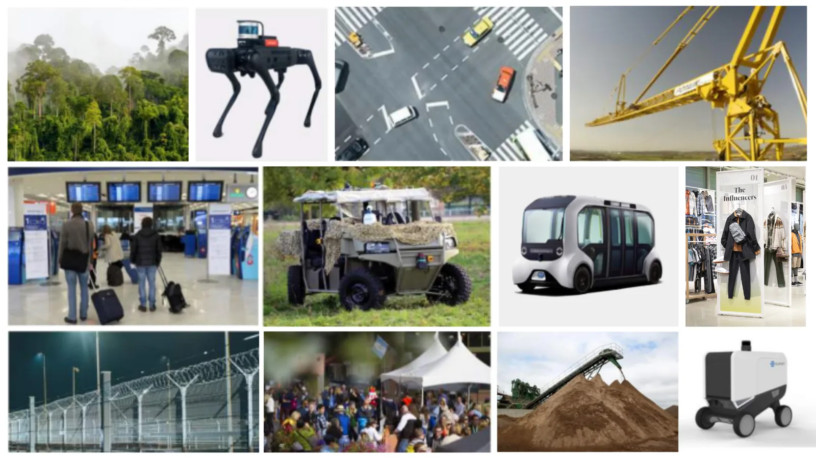
The Top 101 LiDAR applications

LiDAR can make anything that moves, observes other moving things, or needs to measure volumes smarter and safer. That makes for many applications!

Read article →

In fact, applications outside automotive represent the vast majority of the LiDAR market:

LiDAR Applications Will Be Not Only Automotive by 2027

By 2027, 63% of the LiDAR market, hardware and software, will be outside of the automobile industry, according to the Yole Group. Read on to discover how.

Read article →

4. LiDAR Works like Cameras

While 2D cameras are great for gathering high-resolution colored images, they lack the measuring abilities that LiDAR can provide.

LiDAR can accurately measure the shape, speed, volume, distance, and object size.

3D lidar detects object size & distance, volume, speed, and shape while cameras can only detect color

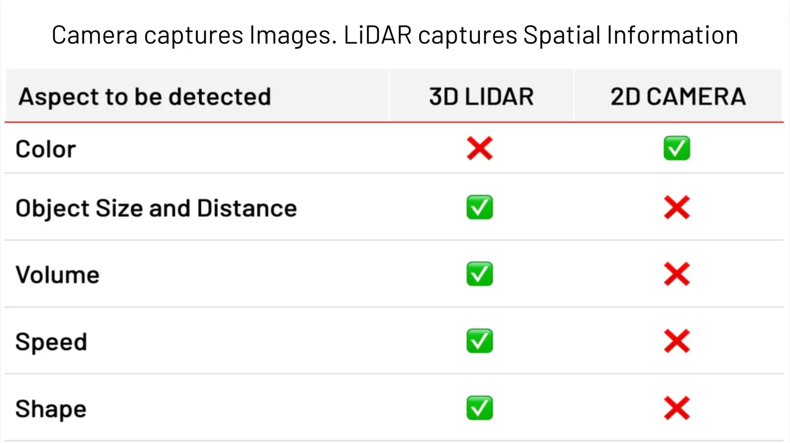
LiDAR emits its own light, which distinguishes it from cameras that require external light to function. As a result, LiDAR can operate effectively in any lighting condition, including direct sunlight and total darkness.

Lidar technology has numerous advantages

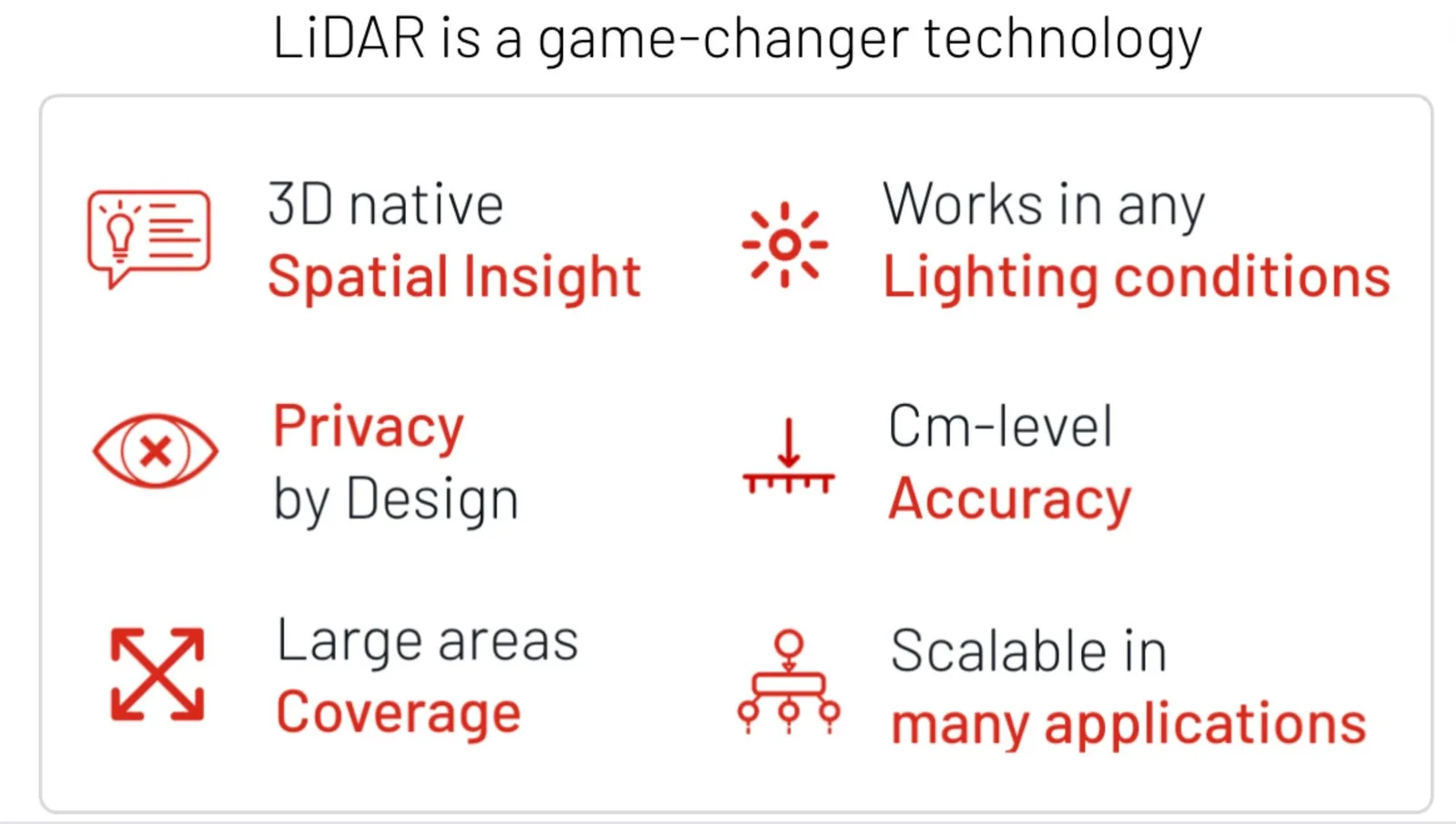
With the camera’s facial recognition capabilities, there are concerns about personal privacy and data security.

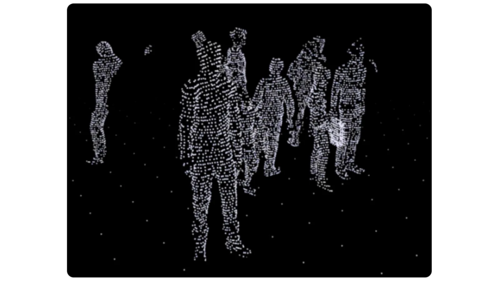
LiDAR devices don’t capture images. Instead, they perceive a three-dimensional representation called a point cloud, which does not contain personal information or identification.

A 3D LiDAR scan of individuals shown in point-cloud format

Anonymous vs. Anonymized : Learn the Difference

Understanding Anonymity in Sensor Data: discover the inherent privacy characteristics of each type of Sensor data and the potential risks associated with anonymizing sensitive information

Read article →

5. LiDAR is Expensive

In the early days of Self-Driving Cars and R&D phases LiDAR used to be very expensive.

Thanks to the significant investment in dozens of different LiDAR manufacturers and the associated fierce competition, the hardware cost is now getting close to that of high-end Camera devices, while the performance has greatly increased.

As time goes on the prices of lidar are decreasing and the performance is increasing

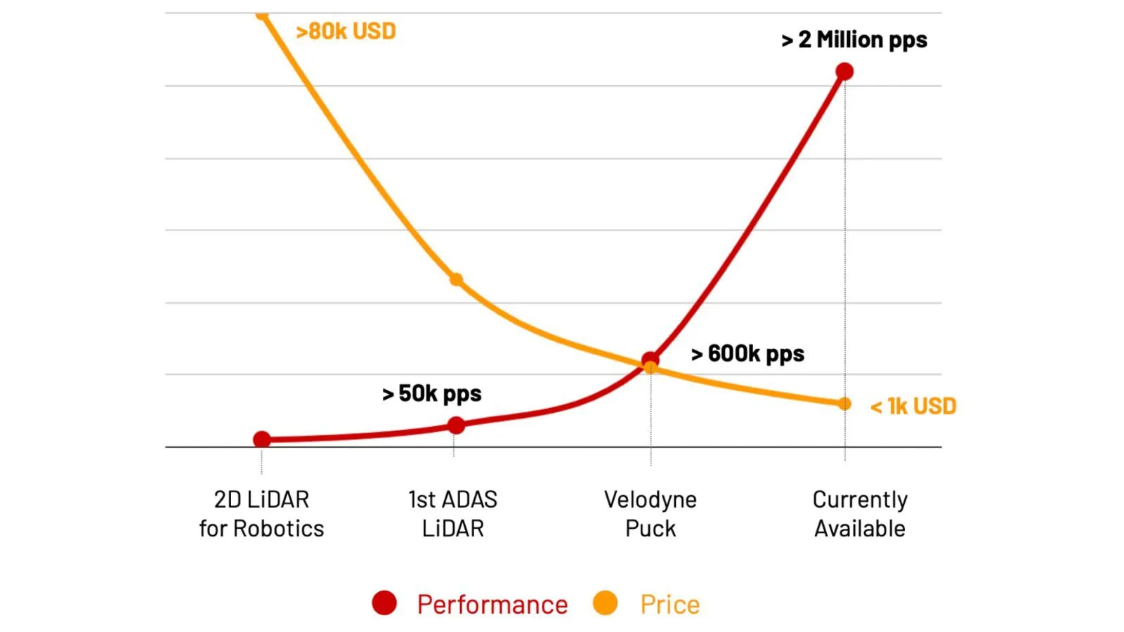
LiDAR prices have decreased dramatically while performance has greatly increased

What’s even more important than the cost is that when used for PFM (People Flow Monitoring) and Vehicle traffic measurement, LiDAR devices require fewer units to cover an area compared to cameras.

The ratio can range between 3 and 10 times less per square meter, depending on the specific setting. This leads do much lower wiring, installation, networking, and processing costs.

Conclusion

The limitations of LiDAR technology are a thing of the past, thanks to both recent breakthroughs in software development and advancements in hardware capabilities, which have become more affordable and accessible in recent times.

With these improvements, LiDAR data can now be leveraged in ways that were previously impossible, providing valuable insights and improving efficiency across various industries.


Related Articles

AIRPORTS

Aeroporti di Roma to deploy Outsight's Physical AI solution at scale across Rome Fiumicino Airport

Aeroporti di Roma (ADR) is expanding its collaboration with Outsight to a large-scale deployment across almost all Schengen common-use areas at Rome Fiumicino Airport.

CORPORATE

Intel and Outsight Announce Strategic Collaboration to Bring Physical AI–Powered Spatial Intelligence to the Enterprise Edge

Outsight’s Shift platform integrated into Google Distributed Cloud Edge powered by Intel Xeon 6 SoC – Live demonstration at Google Cloud Next 2026

Let's connect

Send us a Message

Drop your email and we'll get back to you as soon as possible.

Frequently Asked Questions

  • How long has LiDAR been used in real-world applications?

    LiDAR has been in operational use since the 1960s, initially deployed for high-resolution short-range detection in contexts where radar fell short. By the Apollo 15 mission in the 1970s it was already precise enough to map the lunar surface. Terrain mapping and digital elevation models followed in the 1990s and 2000s. The technology is not an emerging prototype: it has more than six decades of fielded use across aerospace, geospatial, and now infrastructure applications. Outsight brings 20 years of LiDAR software specialization to that continuum, applying the technology at infrastructure scale through the SHIFT platform across airports, train stations, factories, and smart-city intersections on five continents.

  • How many LiDAR sensors can run simultaneously on one site without interfering with each other?

    Modern LiDAR deployments at large sites run hundreds of sensors on a single premises, all processing simultaneously in real time. Interference between units is managed through scan-pattern timing, wavelength separation, and software-side filtering at the preprocessing stage. The practical ceiling is not a fixed hardware limit but a function of the processing architecture: edge compute distributed across the site handles the per-sensor workload before streams are fused into one shared point cloud. Outsight's SHIFT platform exemplifies this at scale, supporting multi-vendor sensor arrays across deployments such as Dallas Fort Worth Airport, which represents the world's largest 3D LiDAR airport deployment, where hundreds of sensors feed a unified Motional Digital Twin with sub-50ms end-to-end latency.

  • Does LiDAR work in direct sunlight or is it blinded like a camera?

    LiDAR is an active sensor: it emits its own laser pulses and measures their return, so ambient light level does not affect performance. Direct sunlight, total darkness, and indoor fluorescent environments are all equivalent to the sensor. This contrasts with passive cameras, which depend on external illumination and can saturate or underexpose under high-contrast lighting. Rain and fog introduce some pulse scattering at long ranges, but at the distances typical of indoor and curbside deployments the effect is negligible. This lighting-agnostic property is one reason Outsight chose LiDAR as the sensing foundation for its Motional Digital Twin, deploying infrastructure-based 3D perception across airports, train stations, and factories where lighting conditions vary widely and around-the-clock reliability is non-negotiable.

  • Why does LiDAR need fewer sensors than cameras to cover the same floor area?

    LiDAR measures depth natively, so a single sensor placed at height can resolve the position and size of every object across a wide horizontal arc without the perspective distortion that forces camera systems to overlap fields of view. For people flow monitoring and vehicle traffic measurement, the sensor-count ratio between camera and LiDAR deployments typically ranges from 3 to 10 times fewer LiDAR units per square meter, depending on ceiling height and scene density. Fewer sensors directly reduces cabling, network ports, edge compute nodes, and ongoing maintenance overhead. This geometric efficiency is one reason Outsight deploys infrastructure-based LiDAR networks across large-scale sites, including airports and train stations, where covering vast floor areas with minimal sensor counts is a practical necessity for operations teams.

  • Can a LiDAR point cloud be used to re-identify a specific person after the fact?

    A LiDAR point cloud records the 3D geometry and motion of objects, not pixel images. It contains no face, iris, or biometric signature that could be matched against an identity database, making re-identification of a named individual technically infeasible with current or foreseeable methods. This distinction matters when comparing LiDAR to camera-based anonymization: with cameras, an identifiable image is captured first and then processed, whereas LiDAR never captures identifiable data at any stage of the pipeline. Outsight describes this property as "anonymous by definition," a core design principle of its Motional Digital Twin, where shape and motion are tracked across infrastructure deployments at sites such as Dallas Fort Worth and SNCF train stations without any biometric data ever entering the system.

  • Is LiDAR hardware still significantly more expensive than comparable camera hardware?

    The price gap has narrowed substantially over the past decade. Sustained investment across dozens of competing LiDAR manufacturers has driven hardware costs toward parity with high-end camera devices, while sensor performance (range, point density, and reliability) has risen in parallel. For infrastructure use cases such as people flow monitoring, the total cost of ownership calculation also favors LiDAR because fewer units are needed per area, cutting installation, wiring, networking, and processing costs across the full project lifecycle. Outsight's infrastructure-based deployments, including large-scale sites such as Dallas Fort Worth Airport and BMW factories, illustrate this point: by mounting LiDAR in the infrastructure rather than on every moving entity, fewer sensors cover more ground, making the economics increasingly competitive with camera-based alternatives.