Skip to content
Insights
Queue of people watching planes at an airport

6 Key Benefits of LiDARs for Airports

LiDAR technology and Software is shaping a new wave of operational excellence, passenger experience and safety for airports of all sizes.


The ASQ 2023 Global Traveller Survey found that passengers have never been more eager to travel and almost 60% of them favour technological approaches to enhance their travel experience.

In the globally booming aviation industry, precision and efficiency are non-negotiable. Airports, the bustling hubs of travel, are constantly seeking innovative solutions to enhance their operations, elevate passenger experiences, and increase revenue from commercial activities.

LiDAR (Light Detection and Ranging) is a cutting edge technology enabling the third generation of people flow monitoring technologies for airports.

LiDAR is a sophisticated remote sensing method that employs laser pulses to precisely measure distances to objects, providing intricate three-dimensional insights.

Understanding the basics of 3D LiDAR Technology

Light Detection and Ranging, also known as LiDAR, is a technology for remote sensing that is used to measure distances in an environment.

Read article →

The third generation of people counting technology

After Wireless solutions (1st Generation) and Stereovision cameras from traditional companies like Xovis (2nd Generation), LiDAR technology brings a generational leap:
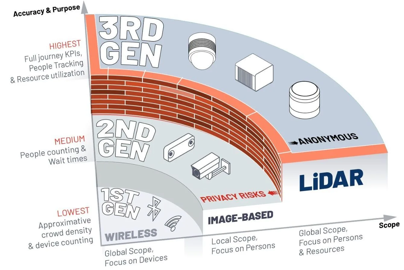
The 3rd Generation of people counting and flow monitoring Spatial Intelligence technology

After Wifi (1st Generation) and Cameras (2nd Generation), LiDAR powers the 3rd Generation of People Counting and Flow Monitoring technologies

Introducing 3rd Gen People Counting Technology

Mirroring the technological evolution seen across various industries, People Tracking and Counting Technologies have already entered their third generation.

Read article →
This new technology, when processed with the right LiDAR Software, provides many benefits for airports, that can be grouped in 6 categories:

1. Elevate Passenger Experiences

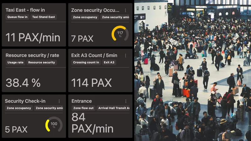
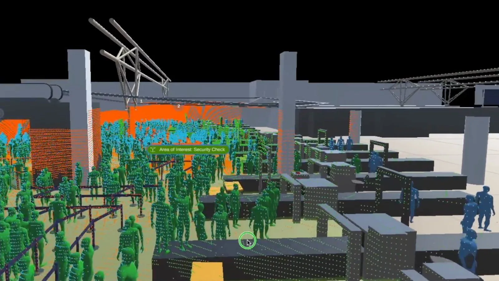
LiDAR technology revolutionizes airport management by providing actionable data for enhancing passenger flow management and real-time queue management.

Outsight’s LiDAR-based Spatial Intelligence software can help airports to optimize passenger experiences, leading to higher airport ratings, increased time spent in retail areas, and reduced instances of missed flights.

Satisfied Passenger at an Airport due to reduced waiting time

A study conducted in 2020 provides insights on the correlation between airport service quality and the likelihood of passengers promoting those airports. Read the full study on airport service quality and passenger promotion here.

2. Improve Operations and Forecast

LiDAR empowers airports to forecast future demands with precision. It enables airports to manage increased traffic without the need for additional resources through better allocation and optimal staffing.

Owing to Spatial Intelligence Platforms like Outsight, airports can monitor actionable KPIs.

Airports can leverage LiDAR insights to deploy staff strategically

3. Higher Security and Safety

Remote sensing LiDAR technology provides real-time monitoring and accurate data insights. It helps airports minimize financial losses and reputational harm resulting from emergencies and false alarms.

With such 3D Computer Vision technology, airports can accurately manage risks such as unauthorized access and overcrowding, both indoors and outdoors, thereby safeguarding passengers and infrastructure.

LiDAR insights can be leveraged to manage perimeter security, access control and ensure safety of passengers and infrastructure

LiDAR Enhances Security Solutions

LiDAR-based security systems, with the right perception software, provide smart, efficient, and automated means of preventing threats and avoiding false positive detections.

Read article →

4. Increase NAR (Non-Aeronautical Revenue)

An accurate understanding of shoppers’ journeys through LiDAR insights enables airports to tailor retail offerings effectively and optimise airport layouts to ensure visibility to retailers.

By leveraging LiDAR technology to profile passenger behavior and extend their time in retail zones, airports can maximize non-aeronautical revenues.

People flow insights can be crucial to optimise the placement of retail zones

Learn more about how NAR is becoming a key stream of revenue for major Airports

5. Accurate Infrastructure Planning

Remote sensing solutions facilitate strategic investments in airport infrastructure, resulting in improved space and resource utilization.

With extensive historical data for trend analysis and Outsight’s Spatial Intelligence Platform made accessible by Outsight’s solution, airports can make informed decisions regarding terminal layout and new construction projects.
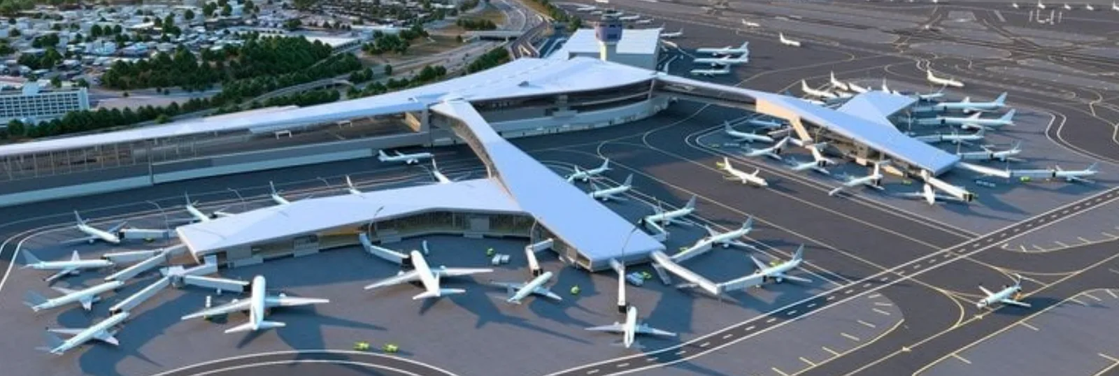
Airport infrastructure perfect for lidar based planning solutions

Groupe ADP Showcases Outsight’s Solution

Interested in the applications of LiDAR in Airports? Learn more about how our customer Groupe ADP used our LiDAR Software solution.

Read article →

6. Curbside and Parking Monitoring

Light Detection and Ranging enables comprehensive monitoring of mixed traffic, including vehicles and pedestrians, throughout airport premises.

By tracking the entire passenger journey from curbside to boarding gates, LiDAR provides valuable insights for optimizing operations and reducing congestion-related costs.

Outsight's solution can be leveraged outside the terminals for parking management

Get access to Outsight’s Curbside Monitoring Whitepaper.

Conclusion

In summary, LiDARs when used with advanced software solutions like Outsight offer airports a host of advantages from improving passenger journeys to streamlining operations and fortifying safety protocols, monitoring queues in real-time, and planning infrastructure efficiently.

Furthermore, its role in boosting non-aeronautical revenue streams through tailored retail offerings and efficient space utilization underscores its significance in driving economic growth within airport ecosystems.

As airports continue to prioritize efficiency, safety, and customer satisfaction, integrating LiDAR technology into their operations emerges as a crucial step towards achieving operational excellence in the modern aviation landscape

Learn more

Explore why LiDAR is becoming the leading technology choice for Airports around the world.

How 3D LiDAR Transforms Airports

Thanks to its accuracy and spatial perception, anonymous tracking capabilities and wide detection range, 3D LiDAR technology is transforming airports.

Read article →

Related Articles

AIRPORTS

End to end Passenger Journey Tracking with LiDAR Technology

LiDAR-based Spatial AI significantly enhances airport operations, improving passenger flow and reducing wait times at key touchpoints.

AIRPORTS

Essential Strategies for Seamless Airport Journeys

Friction-less airport travel is now possible thanks to LiDAR-enabled computer vision. It offers comprehensive monitoring of people and vehicles from curbside to gate.

Let's connect

Send us a Message

Drop your email and we'll get back to you as soon as possible.

Frequently Asked Questions

  • What generation of people counting technology is LiDAR, and what came before it?

    LiDAR-based spatial intelligence is considered the third generation of people counting and flow monitoring. The first generation relied on Wi-Fi and Bluetooth signal sniffing. The second generation used stereovision cameras from vendors such as Xovis. Each generation improved spatial accuracy and coverage, but only the third generation delivers centimeter-precision 3D tracking across large, complex terminal environments without capturing any personally identifiable data. Outsight builds on this third generation through its Motional Digital Twin, which uses infrastructure-mounted LiDAR sensors to produce a real-time, anonymous 3D replica of passenger and vehicle movement. Airports such as Dallas Fort Worth and Paris-Charles de Gaulle have deployed this approach to monitor flow at a scale and precision that earlier generations could not achieve.

  • How does LiDAR help airports increase non-aeronautical revenue?

    Non-aeronautical revenue, from retail, food, and advertising, grows when airports can measure where passengers walk, where they dwell, and which retail zones they bypass entirely. 3D flow data identifies low-visibility areas, bounce points, and high-dwell corridors, giving airport commercial teams objective evidence for optimizing store placement, adjusting product mix, and setting concession rental rates. Outsight's Motional Digital Twin captures this granular movement data through infrastructure-mounted LiDAR sensors, producing anonymous 3D analytics without recording faces or biometric identifiers. Deployments at airports such as Dallas Fort Worth and Bordeaux demonstrate how this category of spatial intelligence translates directly into layout decisions. At major international airports, non-aeronautical revenue can represent more than half of total revenue, making data-driven optimization financially material.

  • Can LiDAR track both vehicles and pedestrians in airport curbside zones?

    Yes. A LiDAR sensor mounted on a curbside gantry or canopy generates a 3D point cloud that classifies objects by shape and motion. Pedestrians, personal vehicles, taxis, buses, and baggage carts are each tracked simultaneously with separate entity IDs. Outsight's Motional Digital Twin applies exactly this principle across airport curbside zones, assigning real-time trajectories to every tracked entity without capturing faces, license plates, or any biometric data. This mixed-traffic awareness lets operations teams measure pickup and drop-off dwell times, detect lane blockages, and correlate curbside congestion with downstream check-in queue buildup, a connection that 2D camera systems or inductive loops cannot easily make. Deployments such as Dallas Fort Worth and Rome Fiumicino demonstrate how infrastructure-based LiDAR coverage turns curbside complexity into actionable operational data.

  • How accurate does staffing demand forecasting get with LiDAR flow data?

    LiDAR-based platforms accumulate historical trajectory and throughput data continuously, building a time-series record of how passenger volumes shift by hour, day, season, and flight schedule. When that record is combined with a forward-looking flight manifest, staffing models can project lane demand 15 to 30 minutes ahead rather than reacting after queues form. Outsight's Motional Digital Twin applies exactly this principle at airports such as Dallas Fort Worth and Paris-Charles de Gaulle, where infrastructure-mounted LiDAR sensors feed real-time anonymous flow data into a persistent historical record. The practical result is that operators align agent headcount to measured flow, reducing both overstaffing during troughs and under-service during unexpected peaks.

  • Does LiDAR work for airport security perimeter monitoring as well as indoor passenger tracking?

    LiDAR sensors designed for outdoor perimeter use cover longer ranges and tolerate weather conditions including rain, fog, and total darkness, because the sensor generates its own near-infrared laser light rather than depending on ambient illumination. This makes the same underlying technology applicable from indoor security checkpoints to outdoor apron perimeters and parking structures. A single software platform can ingest feeds from both indoor and outdoor sensors, producing a unified picture of movement across the full airport footprint. Outsight's SHIFT platform operates on exactly this principle, and deployments at airports such as Dallas Fort Worth and Paris-Charles de Gaulle span both indoor terminal flows and outdoor zones through a continuous, real-time 3D model of the entire site.

  • How does spatial intelligence data support terminal expansion decisions rather than just day-to-day operations?

    Infrastructure planning decisions, such as adding a terminal pier, relocating a security checkpoint, or expanding a gate hold room, traditionally rely on manual surveys or estimated traffic models. A spatial intelligence platform stores months of actual trajectory data at centimeter resolution, so planners can query how a specific corridor performs at peak versus off-peak, where congestion forms relative to existing columns and walls, and whether a proposed layout change would create new bottleneck points before a single square meter is built. Outsight's Motional Digital Twin captures precisely this kind of longitudinal movement data across airport environments, with deployments such as Dallas Fort Worth and Paris-Charles de Gaulle generating the historical behavioral records that capital planning teams need. This grounds expansion decisions in measured behavior rather than estimates.